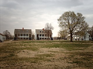
Fort Scott National Historic Site is a historical area under the control of the United States National Park Service in Bourbon County, Kansas, United States. Named after General Winfield Scott, who achieved renown during the Mexican–American War, during the middle of the 19th century the fort served as a military base for US Army action in what was the edge of settlement in 1850. For the next quarter century, it was used as a supply base and to provide security in turbulent areas during the opening of the West to settlement, a period which included Bleeding Kansas and the American Civil War.
The Third Colorado Cavalry was formed in the mid-1860s when increased traffic on the United States emigrant trails and settler encroachment resulted in numerous attacks against them by the Cheyenne and Arapaho. The Hungate massacre and the display in Denver of mutilated victims raised political pressure for the government to protect its people. Governor John Evans sought and gained authorization from the War Department in Washington to found the Third. More a militia than a military unit, the "Bloodless Third" was composed of "100-daysers," that is, volunteers who signed on for 100 days to fight against the Indians.
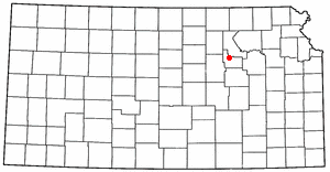
Kansas has always been home to many forts and military posts.
In 1862 the citizens of Burlingame, Kansas, constructed a stone fort around the town well, in an intersection in the business district. This was done to prevent the burning of Burlingame by Confederate guerrilla William Anderson, later known as Bloody Bill Anderson. He and his family had lived in a neighboring county up to 1862, but Anderson got into considerable trouble and was forced to leave. Upon leaving, Anderson threatened to burn Burlingame.

Fort Aubrey, in eastern Hamilton County, Kansas, was established by the US Army in the 1850s. It originally had no name and was not made a truly permanent post until 1865. It was originally established to serve as a temporary resting place for traveling troops. The location of the fort is based upon a recommendation by François Xavier Aubry, for whom the fort is named.
In the early 1860s Stephen B. Chapman and his family lived on a farm near the town of Black Jack, south of Lawrence, Kansas. In summer 1863 Bushwhackers began traveling through the area, terrorizing the citizens. After William C. Quantrill's Lawrence Massacre on August 21, 1863, the family in September moved west, since the guerrillas passed within sight of their farm.
Fort Belmont, in southern Woodson County, Kansas, was built about 1860 near the town of Belmont. It was to protect the settlers there from attacks by Border Ruffians and Indians. The fort consisted of three or four officer cabins, a redoubt about a quarter of a mile to the north and a parade ground a mile to the east.
In spring and probably into summer 1864 Fort Henning was constructed. It, along with Fort Blair and Fort Insley, was built to help protect the city and post of Fort Scott. Fort Henning, located at the intersection of Second and National Streets, was almost in the center of town. Fort Henning was an octagonal structure and measured fourteen feet across. It was the smallest of the three blockhouse forts.
In spring and summer 1864 Fort Blair, Fort Henning and Fort Insley were constructed to help protect the town and post of Fort Scott from Confederate forces. Fort Insley was named for Capt. Martain H. Insley. It was located just northeast of town, about 1½ blocks northeast of the main part of the post of Fort Scott. It overlooked Buck Run Creek.
In 1864 Gen. Samuel R. Curtis established a military camp at the Fort Riley-Fort Larned Road crossing of the Smokey Hill River in what is now Ellsworth County, Kans.
Fort Lincoln was established about August 24, 1861, by United States Senator James Lane. Earlier in August, Lane had reestablished Fort Scott as a military post. Soon Confederate troops under Maj. Gen. Sterling Price threatened to overrun the newly reopened post.
Sometime in 1864 a large log blockhouse was removed from Fort Lincoln, Kansas, and was relocated to the town of Fort Scott, Kansas. This blockhouse was placed at the intersection of Lowman and First streets. Probably a stockade, possibly also removed from Fort Lincoln, was erected around the blockhouse.
Fort Lookout, in the northeast corner of Republic County, Kansas, was established by the US Army near the beginning of the American Civil War, in 1861. Its purpose was to protect the military road running from Fort Riley, Kansas, to Fort Kearney, Nebraska Territory. The area witnessed many attacks by Indians. Fort Lookout was perched on a high bluff overlooking the Republican River. The fort was two miles south of the Kansas-Nebraska border.
Fort Montgomery in the town of Eureka, Kansas was built in summer 1861 by local citizens for protection against Indian attacks and Confederate guerrilla forces.
Fort Row, located on the south bank of the Verdigris River and east of the present town of Coyville, Kansas, was built in the fall of 1861, probably in October. It was built by the local mounted militia for their use. However, the fort became associated with one of the worst human tragedies of the Civil War.
In early 1864 settlers in Ottawa County, Kansas, began building Fort Solomon and completed it by the spring or summer. This structure replaced the much smaller dugout owned by the Chapman family and used as a refuge in times of trouble. The Chapman dugout was about a mile south of Fort Solomon. The new white settlers and the Indians in the area quickly developed a hostile relationship and many Indian raids followed.
Salina's Stockade was built in Salina, Kansas, to provide the residents with protection from the American Indians in the area, many of whom were hostile toward white settlement. While Salina had been raided in 1862 by Native Americans and then Confederate guerrillas, it was not until May 1864 when residents decided they needed to build a stockade for protection. On May 17, 1864, a makeshift stockade, consisting of wagons placed in a circle around the town's flagpole, was erected. The local militia then drilled and guarded Salina. On the northeast corner of 7th Street and Iron Avenue stood a small building. Around this a permanent stockade was erected in May and June 1864.
In spring 1860 the Washington Town Company laid out the town site of Washington, Kansas. A log cabin was built as the headquarters of the town company and this became known as the Washington Company House. The logs of this building were set up perpendicular, so the outside of the building resembled a stockade.One of its uses was to serve as a place of refuge when problems arose with area Indians opposed to white settlement of the area.