
The Duwamish River is the name of the lower 12 miles (19 km) of Washington state's Green River. Its industrialized estuary is known as the Duwamish Waterway.

The Montlake Cut is the easternmost section of the Lake Washington Ship Canal, which passes through the city of Seattle, linking Lake Washington to Puget Sound. It is approximately 2,500 feet (760 m) long and 350 feet (110 m) wide. The center channel is 100 feet (30 m) wide and 30 feet (9.1 m) deep. The path along the cut was designated a National Recreation Trail as Montlake Cut National Waterside in 1971.

State Route 599 (SR 599) is a state highway and freeway in King County, Washington, United States. It is located entirely within the city of Tukwila and travels 1.75 miles (2.82 km) northwest along the Duwamish River between junctions with Interstate 5 (I-5) and SR 99. The freeway has one intermediate exit and follows the Central Link light rail line.

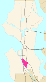
The Industrial District is the principal industrial area of Seattle, Washington. It is bounded on the west by the Duwamish Waterway and Elliott Bay, beyond which lies Delridge of West Seattle; on the east by Interstate 5, beyond which lies Beacon Hill; on the north by S King and S Dearborn Streets, beyond which lie Pioneer Square and southwest International District of Downtown; and on the south by the main lines of the BNSF Railway and Union Pacific Railroad, or about S Lucille Street, beyond which is Georgetown. SoDo is the name of the northwest portion of the neighborhood, named for its being South of Downtown. SoDo is the location of T-Mobile Park, home of the Seattle Mariners, and CenturyLink Field, home of the Seattle Seahawks and Seattle Sounders FC. CenturyLink Field was also the site of the former Kingdome.

Allentown is a neighborhood of Tukwila, Washington, on the Duwamish River. It is situated between the Rainier View neighborhood of southern Seattle and the Boulevard Park neighborhood of unincorporated King County.
Georgetown is a neighborhood in Seattle, Washington, USA. It is bounded on the north by the mainlines of the BNSF Railway and Union Pacific Railroad, beyond which is the Industrial District; on the west by the Duwamish River, across which is South Park; on the east by Interstate 5, beyond which is Beacon Hill; and on the south by Boeing Field.
Lincoln Park is a 135 acres (0.55 km2) park in West Seattle between Fauntleroy Way S.W. and Puget Sound. One of Seattle's largest parks, attractions include the paved walkway along the beach, tennis courts, baseball fields, picnic shelters, and a heated saltwater swimming pool during the summer. The park is easily accessible by car, boat or bus and is located next to the Washington State Ferries Fauntleroy terminal. The park is adjacent to the Fauntleroy neighborhood.

Hamilton Viewpoint is a 16.9-acre (6.8 ha) public park in the West Seattle neighborhood of Seattle, Washington, United States. It was acquired by the city in 1914 and became a park 40 years later. Its namesake is Rupert L. Hamilton, a noted figure in the West Seattle community who helped establish the park. It had previously been known as West Side Park and Duwamish Head Park.

South Park is a neighborhood in the city of Seattle, in the U.S. state of Washington. It is located just south of Georgetown across the Duwamish River, and just north of the city of Tukwila. Its main thoroughfares are West Marginal Way S., S. Cloverdale Street and 14th Ave. S (north-and-south). South Park connects to Georgetown by two bridges at 1st Ave S. at the northmost end of the neighborhood, and the South Park Bridge at the north end of 14th Ave. South. The South Park Bridge was closed on June 30, 2010 and reconstructed due to safety concerns. The newly constructed bridge reopened to traffic on June 30, 2014.

Starfire Sports is a sporting facility in Tukwila, Washington, on the banks of the Green River, near Seattle. It is operated by the non-profit corporation Starfire Sports and is home to several soccer and rugby teams. At the time of its opening, CEO Chris Slatt believed it to be "the largest synthetic-turf soccer complex in the U.S." Seattle Sounders FC has offices and training facilities at the complex, and stages Lamar Hunt U.S. Open Cup matches at the main stadium. Their affiliate team, Seattle Sounders FC 2, played at Starfire from 2015 to 2017. The Seattle affiliate of Major League Rugby, the Seattle Seawolves, began play at Starfire Sports in Spring 2018.

Tyee Educational Complex is a public high school campus located in SeaTac, Washington, United States. It was founded as Tyee High School, a single public high school, in 1962. It is operated by the Highline School District.
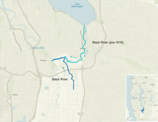
The Black River is a tributary of the Duwamish River in King County in the U.S. state of Washington. It drained Lake Washington until 1916, when the opening of the Lake Washington Ship Canal lowered the lake, causing part of the Black River to dry up. It still exists as a dammed stream about 2 miles (3.2 km) long.
Renton High School is a public secondary school in downtown Renton, Washington, U.S., about 10 miles southeast of downtown Seattle. Founded in 1911, it is the oldest high school in the Renton School District.
Orillia, Washington was a former community, southwest of Renton in the Green River Valley of King County in the U.S. state of Washington. At one time, it had a schoolhouse. Today it lies on the border between the cities of Kent, Tukwila and Renton.
Riverton is a census-designated place (CDP) in King County, Washington, United States. The population was 6,407 at the 2010 census. Riverton was formerly part of the Riverton-Boulevard Park CDP, which was split up for the 2010 census into Riverton and Boulevard Park.

Foster, Washington was a former community in King County in the U.S. state of Washington. Today, after being annexed in 1989, Foster's former area is a part of the city of Tukwila.

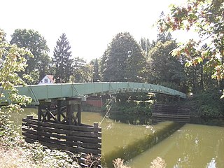
The Green River Trail is a 19.6-mile (31.5 km) pedestrian and bicycle trail in King County, Washington, USA. It runs along the banks of the Duwamish and Green Rivers, crossing the river several times on bridges. The trail goes through a variety of landscapes, ranging from industrial to rural.
The 2011 W-League season was the 17th season of the league's existence, and 8th season of second division women's soccer in the United States. The regular season began on May 14 and ended on July 17.

North Wind's Weir or North Wind's Fish Weir south of Seattle on the Duwamish River in Tukwila, Washington is a site that figures prominently in the oral traditions of the Salish people of the Puget Sound region. The legends describe battles between North Wind and South Wind for control of the region.


