Related Research Articles
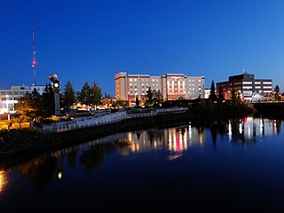
Fairbanks is a home rule city and the borough seat of the Fairbanks North Star Borough in the U.S. state of Alaska.

Nenana (Lower Tanana: Toghotili; is a home rule city in the Yukon-Koyukuk Census Area of the Unorganized Borough in the Interior of the U.S. state of Alaska. Nenana developed as a Lower Tanana community at the confluence where the tributary Nenana River enters the Tanana. The population was 378 at the 2010 census, down from 402 in 2000.

Tanana is a city in the Yukon-Koyukuk Census Area in the U.S. state of Alaska. At the 2010 census the population was 246, down from 308 in 2000. It was formerly known as Clachotin, adopted by Canadian French.

The District of Alaska was the governmental designation for Alaska from May 17, 1884 to August 24, 1912, when it became Alaska Territory. Previously it had been known as the Department of Alaska. At the time, legislators in Washington, D.C., were occupied with post–Civil War reconstruction issues, and had little time to dedicate to Alaska. General Jefferson C. Davis, a U.S. Army officer, was put in charge as the first commander of the Department of Alaska, which between 1884 and 1912 was renamed the District of Alaska and was appointed a civil government by President Chester A. Arthur with the passage of the First Organic Act. During the Department era, Alaska was variously under the jurisdiction of the U.S. Army, the United States Department of the Treasury and the U.S. Navy, but now the area had its own government.
The Richardson Highway is a highway in the U.S. state of Alaska, running 368 miles (562 km) and connecting Valdez to Fairbanks. It is marked as Alaska Route 4 from Valdez to Delta Junction and as Alaska Route 2 from there to Fairbanks. It also connects segments of Alaska Route 1 between the Glenn Highway and the Tok Cut-Off. The Richardson Highway was the first major road built in Alaska.

The Alaska Railroad is a Class II railroad which extends from Seward and Whittier, in the south of the state of Alaska, in the United States, to Fairbanks, and beyond to Eielson Air Force Base and Fort Wainwright in the interior of that state. At one time in its history, it extended to the banks of the Yukon River northeast of Fairbanks. Uniquely, it carries both freight and passengers throughout its system, including Denali National Park. The railroad has a mainline over 656 miles (1,056 km) long and is well over 500 miles (800 km) including branch lines and siding tracks. It is currently owned by the state of Alaska. The railroad is connected to the contiguous 48 via three rail barges that sail between the Port of Whittier, Alaska and Harbor Island in Seattle but does not currently have a direct, land-based connection with any other railroad lines on the North American network. In 2016, the company suffered a net loss of $4.3 million on revenues of $169.8 million, holding $1.1 billion in total assets.

Klondike Gold Rush National Historical Park is a national historical park operated by the National Park Service that seeks to commemorate the Klondike Gold Rush of the late 1890s. Though the gold fields that were the ultimate goal of the stampeders lay in the Yukon Territory, the park comprises staging areas for the trek there and the routes leading in its direction. There are four units, including three in Municipality of Skagway Borough, Alaska and a fourth in the Pioneer Square National Historic District in Seattle, Washington.
The 22nd Infantry Regiment is a parent regiment of the United States Army. Currently the 2nd Battalion is active, with the regimental colors residing at Fort Drum, New York. The 1st, 3rd, and 4th Battalions have been inactivated.

Chena was a former city in interior Alaska, located in the Fairbanks North Star Borough, Alaska, United States, near the confluence of the Chena and Tanana rivers. It incorporated in 1903 and was disincorporated in 1973. The area is now part of the outskirts of Fairbanks, within the CDP of Chena Ridge. Its heyday was in the first two decades of the 20th century, with a peak population of about 400 in 1907. By 1910 the population had fallen to 138.

The Hän, Han or Hwëch'in / Han Hwech’in are a First Nations people of Canada and an Alaska Native Athabaskan people of the United States; they are part of the Athabaskan-speaking ethnolinguistic group. Their traditional lands centered on a heavily forested area around the Upper Yukon River, Klondike River (Tr'on'Dëk), Bonanza Creek and Sixtymile River and straddling what is now the Alaska-Yukon Territory border. In later times, the Han population became centered in Dawson City, Yukon and Eagle, Alaska.

The history of Yukon covers the period from the arrival of Paleo-Indians through the Beringia land bridge approximately 20,000 years ago. In the 18th century, Russian explorers began to trade with the First Nations people along the Alaskan coast, and later established trade networks extending into Yukon. By the 19th century, traders from the Hudson's Bay Company were also active in the region. The region are administered as a part of the North-Western Territory until 1870, when the United Kingdom transferred the territory to Canada.

The Yukon Field Force, later termed the Yukon Garrison, was a unit of 203 officers and men from the Permanent Force of the Canadian Militia that served in the Yukon between 1898 and 1900. The force was created in the wake of the Klondike Gold Rush in response to fears that the United States might attempt to seize the region. It left Ottawa on May 6 1898, travelling by rail and sea to the port of Glenora in British Columbia. From there, the unit made an arduous journey of 890 kilometres (550 mi) on foot and using makeshift boats to Fort Selkirk, where they established their headquarters. A detachment of 72 men was sent to the boom town of Dawson City to support the North-West Mounted Police, with duties that included guarding the gold deposits of the local banks. As the fears of an annexation reduced, pressures grew for the recall of the force. The force was halved in size in July 1898 and the remainder were finally withdrawn in June 1900.
Fort Egbert was a U.S. Army base in Eagle, Alaska. It operated from 1899 to 1911.
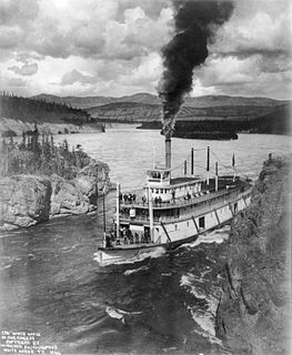
Steamboats on the Yukon River played a role in the development of Alaska and Yukon. Access to the interior of Alaska and Yukon was hindered by large mountains and distance, but the wide Yukon River provided a feasible route. The first steamers on the lower Yukon River were work boats for the Collins Overland Telegraph in 1866 or 1867, with a small steamer called Wilder. The mouth of the Yukon River is far to the west at St. Michael and a journey from Seattle or San Francisco covered some 4,000 miles (6,400 km).
The Alaska Communications System (ACS), also known as the Washington-Alaska Military Cable and Telegraph System (WAMCATS), was a system of cables and telegraph lines authorized by the U.S. Congress in 1900 and constructed by the U.S. Army Signal Corps. The communications lines were to serve both military and civilian needs in the territory of Alaska. By 1904, ACS comprised some 2,100 miles (3,400 km) of undersea cable, over 1,400 miles (2,300 km) of land lines, and a wireless segment across at least 107 miles (172 km). On May 15, 1936 WAMCATS was renamed the U.S. Army Alaska Communications System. The Alaska Communications System remained under the control of the Army Signal Corps until 1962 when it was taken over by the U.S. Air Force. The ACS handled the radioteletype, radio telephone, 500 kHz ship-to-shore frequencies, collected communications intelligence, and other services for more than half a century in Alaska.
Fort Liscum was a United States Army post in the Alaska Territory on the south shore of Valdez Bay, across from the modern site of Valdez, Alaska. It operated from 1900 to 1922.

The history of Fairbanks, the second-largest city in Alaska, can be traced to the founding of a trading post by E.T. Barnette on the south bank of the Chena River on August 26, 1901. The area had seen human occupation since at least the last ice age, but a permanent settlement was not established at the site of Fairbanks until the start of the 20th century.
United States Army Alaska is a military command of the United States Army located in the U.S. state of Alaska. A subordinate command of I Corps, USARAK is the ground element of the Alaskan Command. USARAK is headquartered at Joint Base Elmendorf-Richardson and is commanded by a major general.

Mount Billy Mitchell is a prominent 6,919-foot (2,109 m) peak located in the Chugach Mountains, 35 miles (56 km) east of Valdez and 12 miles (19 km) west of the Copper River in the U.S. state of Alaska. This mountain forms a prominent and easily visible landmark between mile markers 43 and 51 of the Richardson Highway, as the highway passes just to its west between Tonsina and the Thompson Pass.
Fort St. Michael was an installation of the United States Army at St. Michael, Alaska, on St. Michael Island in Norton Bay on the central west coast of Alaska. The fort was in active service between 1897 and 1925, and was originally established to maintain order during the Klondike Gold Rush for which St. Michael was a major transshipment point for people and goods moving up the Yukon River, whose mouth is nearby but is inaccessible to ocean-going ships. The installation later became the endpoint of the WAMCATS cable, a military communications cable extending across Alaska. Its importance declined substantially after the Alaska Railroad was completed in 1923, providing year-round service to the interior which was superior to the seasonal transport service of the river. The post was closed in 1925, and the military burials of its graveyard relocated to Sitka National Cemetery in 1929. When surveyed in 1976, only three buildings remained of the once extensive installation.
References
- Fort Gibbon and the Village of Tanana, University of Alaska, Anchorage, retrieved February 9, 2012
- The 22nd Infantry Regiment in Alaska 1908-1910, 22nds Infantry Regiment Society, retrieved February 9, 2012
| | This United States Army article is a stub. You can help Wikipedia by expanding it. |
| | This article about a location in the Yukon-Koyukuk Census Area, Alaska is a stub. You can help Wikipedia by expanding it. |