Fort Lincoln (Kansas)

Last updated

Fort Lincoln was established about August 24, 1861, by United States Senator James Lane. Earlier in August, Lane had reestablished Fort Scott as a military post. Soon Confederate troops under Maj. Gen. Sterling Price threatened to overrun the newly reopened post.

United States Senate Upper house of the United States Congress

The United States Senate is the upper chamber of the United States Congress, which along with the United States House of Representatives—the lower chamber—comprises the legislature of the United States. The Senate chamber is located in the north wing of the Capitol, in Washington, D.C.

Fort Scott National Historic Site

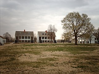
Fort Scott National Historic Site is a historical area under the control of the United States National Park Service in Bourbon County, Kansas, United States. Named after General Winfield Scott, who achieved renown during the Mexican–American War, during the middle of the 19th century the fort served as a military base for US Army action in what was the edge of settlement in 1850. For the next quarter century, it was used as a supply base and to provide security in turbulent areas during the opening of the West to settlement, a period which included Bleeding Kansas and the American Civil War.

Confederate States of America (de facto) federal republic in North America from 1861 to 1865

The Confederate States of America, commonly referred to as the Confederacy and the South, was an unrecognized country in North America that existed from 1861 to 1865. The Confederacy was originally formed by seven secessionist slave-holding states—South Carolina, Mississippi, Florida, Alabama, Georgia, Louisiana, and Texas—in the Lower South region of the United States, whose economy was heavily dependent upon agriculture, particularly cotton, and a plantation system that relied upon the labor of African-American slaves.

Lane moved 1200 troops, most of the citizens of the town of Fort Scott, and some refugees from Missouri to a point 15 miles northwest of Fort Scott. On some low ground on the north side of the Little Osage River, Fort Lincoln was established. The post was named for President Abraham Lincoln. Lane was criticized for choosing such a low spot, because it was difficult to see enemy troops coming and the area was prone to flooding during periods of heavy rains. [1]

Fort Scott, Kansas City and County seat in Kansas, United States

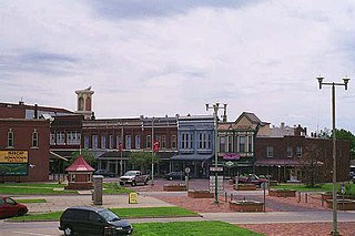
Fort Scott is a city in and the county seat of Bourbon County, Kansas, United States, 88 miles (142 km) south of Kansas City, on the Marmaton River. As of the 2010 census, the city population was 8,087. It is the home of the Fort Scott National Historic Site and the Fort Scott National Cemetery. Fort Scott is named for Gen. Winfield Scott.

Missouri State of the United States of America

Missouri is a state in the Midwestern United States. With over six million residents, it is the 18th-most populous state of the Union. The largest urban areas are St. Louis, Kansas City, Springfield, and Columbia; the capital is Jefferson City. The state is the 21st-most extensive in area. In the South are the Ozarks, a forested highland, providing timber, minerals, and recreation. The Missouri River, after which the state is named, flows through the center of the state into the Mississippi River, which makes up Missouri's eastern border.

Little Osage River tributary of the Osage River in eastern Kansas and western Missouri in the United States

The Little Osage River is an 88-mile-long (142 km) tributary of the Osage River in eastern Kansas and western Missouri in the United States. Via the Osage and Missouri rivers, it is part of the watershed of the Mississippi River.

The post consisted of a number of buildings surrounded by a 5-foot-high (1.5 m) earthwork embankment. One large blockhouse was relocated to the town of Fort Scott about 1864 to help protect it and the post of Fort Scott. The town of Fort Lincoln was also established by Lane outside the post in 1861. [2]

Once the threat to Fort Scott disappeared in September 1861, Lane took most of his troops from Fort Lincoln, leaving about 300 infantry and cavalry troops. In 1862, Lane's force was disbanded and the post was occupied by black Union soldiers, who guarded the post as a prisoner of war camp. Many Confederates were incarcerated there. In April 1863 the black troops were replaced by white troops. Between May and August 1863 the military abandoned the use of Fort Lincoln. [3]

After its abandonment, George Walrod moved his family inside the fort. Walrod garrisoned the post as a one-man operation. Walrod died in October 1863 and in the winter a militia was formed in the area. The militia probably made use of Fort Lincoln until its destruction by retreating Confederates under Price on October 25, 1864. It was never rebuilt and the town of Fort Lincoln eventually disappeared. [4]

See also

Related Research Articles

Border states (American Civil War) slave states that had not declared a secession from the Union during the American Civil War

In the context of the American Civil War (1861–65), the border states were slave states that did not declare a secession from the Union and did not join the Confederacy. To their north they bordered free states of the Union and to their south they bordered Confederate slave states. Of the 34 U.S. states in 1861, nineteen were free states and fifteen were slave states. Two slave states never declared a secession or adopted an ordinance: Delaware and Maryland. Four others did not declare secession until after the Battle of Fort Sumter and were briefly considered to be border states: Arkansas, North Carolina, Tennessee and Virginia—after this, they were less frequently called "border states". Also included as a border state during the war is West Virginia, which was formed from 50 counties of Virginia and became a new state in the Union in 1863.

Fort Baxter, also known as Fort Blair, was a small US Army post located in the southeast corner of Kansas near present-day Baxter Springs. This area was known as the Cherokee Strip. It was one of a few Kansas forts attacked by Confederate forces during the American Civil War. At one point the Confederate government claimed authority over the Neutral Lands. Both Union and Confederate troops operated in the area, as did guerrilla forces and militias prevalent in the Kansas-Missouri border area.

Kansas has always been home to many forts and military posts.

Barnesville's Post located near Barnesville, in Bourbon County, Kansas, was the site of military camps for stretches of time during the American Civil War. The first mention of a camp there came from a report written on September 4, 1861, by Sen. James Lane. This was during the time Lane had evacuated Fort Scott and moved his forces to areas north of that post. A post was established at Barnesville. Lane wrote to Capt. W. E. Prince, then commanding Fort Leavenworth, "I am holding Barnesville. .. with an irregular force of about 250 men, stationed in log buildings, and am now strengthening their position with earth entrenchments."

In 1862 the citizens of Burlingame, Kansas, constructed a stone fort around the town well, in an intersection in the business district. This was done to prevent the burning of Burlingame by Confederate guerrilla William Anderson, later known as Bloody Bill Anderson. He and his family had lived in a neighboring county up to 1862, but Anderson got into considerable trouble and was forced to leave. Upon leaving, Anderson threatened to burn Burlingame.

In early May 1863 a temporary camp, Camp Hooker, was established at the site of what later became Baxter Springs, Kansas. This area was located in what was known as the Cherokee Strip (Kansas). In late May while the camp commander, Col. James M. Williams, was in Fort Scott, the troops moved the camp three blocks to the east to what is now Washington School Hill. The new camp, Camp Ben Butler (named after Maj. Gen. Benjamin Butler, was in a highly defendable position. It occupied a plateau that covered more than two square blocks. Only a small area to the south allowed easy access to camp. In fact, much of the surrounding area was practically impenetrable by men or horses.

Camp Defiance was a military encampment in eastern Kansas, U.S., during 1861–1862. In December 1861, the town of Potosi, Kansas, along the Kansas-Missouri border, was attacked by Confederate guerrillas. Very soon Col. James Montgomery stationed the Kansas 3rd Regiment about 4 miles (6 km) to the northeast.

Council Grove's Post is a trading post on the Santa Fe Trail that operated in Council Grove, Kansas. It was established around 1861 and decommissioned around 1864, with ties to the Civil War.

Fort Belmont, in southern Woodson County, Kansas, was built about 1860 near the town of Belmont. It was to protect the settlers there from attacks by Border Ruffians and Indians. The fort consisted of three or four officer cabins, a redoubt about a quarter of a mile to the north and a parade ground a mile to the east.

In spring and probably into summer 1864 Fort Henning was constructed. It, along with Fort Blair and Fort Insley, was built to help protect the city and post of Fort Scott. Fort Henning, located at the intersection of Second and National Streets, was almost in the center of town. Fort Henning was an octagonal structure and measured fourteen feet across. It was the smallest of the three blockhouse forts.

In spring and summer 1864 Fort Blair, Fort Henning and Fort Insley were constructed to help protect the town and post of Fort Scott from Confederate forces. Fort Insley was named for Capt. Martain H. Insley. It was located just northeast of town, about 1½ blocks northeast of the main part of the post of Fort Scott. It overlooked Buck Run Creek.

Sometime in 1864 a large log blockhouse was removed from Fort Lincoln, Kansas, and was relocated to the town of Fort Scott, Kansas. This blockhouse was placed at the intersection of Lowman and First streets. Probably a stockade, possibly also removed from Fort Lincoln, was erected around the blockhouse.

Fort Montgomery in the town of Eureka, Kansas was built in summer 1861 by local citizens for protection against Indian attacks and Confederate guerrilla forces.

Fort Simple was an American fort built in Topeka, Kansas, as a result of Maj. Gen. Sterling Price's Missouri Raid in the late summer and fall of 1864. Topeka had become the permanent capital of the State of Kansas in 1861, but no fortifications had been built to protect the city from guerrilla bands, which roamed eastern Kansas. Even the raid and massacre in August 1863 in Lawrence, Kansas, did not result in a fort being built to protect the capital, although plans had been made to build one by July 1864.

The following is a timeline of the history of Topeka, Kansas, USA.

The Lawrence blockhouses where a series of blockhouses built in the spring of 1864 in Lawrence, Kansas, to provide defensive structures in case of attack by Confederate guerrillas. On August 21, 1863, Lawrence had been attacked by 400 guerrillas and Confederate Army recruits under the command of William C. Quantrill. Lawrence was caught virtually defenseless and much of the town was destroyed and about 180 men and boys were killed, most of them defenseless. A militia became active by spring 1864 to prevent another attack.

Livingston's Hideout was most likely the only permanent Confederate military camp inside Kansas during the Civil War. It was in the very corner of southeast Kansas, in the very corner of Cherokee County, Kansas. It was about 2 miles (3.2 km) north of the border with Indian Territory and it was less than 100 feet (30 m) west of the border with Missouri. It was 5 miles (8.0 km) west of Baxter Springs, where a series of Union military posts existed from 1862 to 1863. Thomas R. Livingston became a leader of a group of Confederate guerrillas in the area, becoming first a captain and then a major. He needed locations to hide himself and his guerrillas from pursuing Union troops and this hideout suited the guerrillas well. The guerrillas sought to spy on Union forces and raiding units he found small enough to defeat.

Potosi's post, in eastern Linn County, Kansas, was established at the small town of Potosi, Kansas, founded in 1857 by those loyal to the southern cause in Kansas. The other side, the free-staters, soon gained control of the town and it was loyal to the Union when the Civil War broke out in 1861. Potosi was located along the north bank of Mine Creek and it was along the military road running from Fort Leavenworth to Fort Gibson. At its height the town had thirty residents, a store and a post office.

Paola's post, sometimes called Post Paola, in Miami County, Kansas, was located on the west side of Bull Creek, just west of Paola, Kansas. It was probably established in December 1861, as that was the first time it was mentioned. This post became one of the more important posts along the Kansas-Missouri border during the Civil War. It became a district headquarters in 1863. Later, in September 1864, it was designated a subdistrict headquarters, when the district headquarters was moved to Lawrence, Kansas. The military road from Fort Leavenworth to Fort Gibson ran through Paola, thus ensuring the post always had some importance.

In 1842 a large log fort was built at Trading Post by the United States Army, upon the order of Gen. Winfield Scott. This fort was on the Fort Leavenworth-Fort Gibson Military Road. The completed fort was fairly elaborate. It included space to house a company of dragoons and their horses. Also, it contained a hospital and store houses. Gaps along the outside walls of buildings were filled in with stockade walls. The buildings were built around a large interior open area.

References

  1. History of the State of Kansas (Chicago: A. T. Andreas, 1883), p. 1098; "Letter from Capt. Quigg's Company," Freedom's Champion (Atchison, Kans.), September 14, 1861, p. 1; Sen. James H. Lane, report, The War of the Rebellion (Washington: Government Printing Office, 1881), pp. 454-5; William C. Pollard, Jr., "Forts and Military Posts in Kansas: 1854-1865" (Ph.D. dissertation, Faith Baptist College and Seminary, 1997), p. 54.
  2. "Some of the Lost Towns of Kansas," Collections of the Kansas State Historical Society, 1911-1912, Vol. XII (Topeka, State Printing Office, 1912), p. 448;Christian H. Isely, map, ca. December 1863, p. 1 (from the Wichita State U. Special Collection, Wichita, Kans.); "Fort Lincoln, Kansas," The Civil War News, December 1992, p. 45; Pollard, interview with Ola May Earnest, Fort Lincoln site, Kans., October 31, 1992.
  3. Isely, p. 1; Sherman Bodwell, unpublished diary, April 20, 1863, entry (from the Manuscript Div. of the Kansas State Historical Society, Topeka, Kans.); Charles M. Chase, letter to the True Republican and Sentinel, (Sycamore, Ill.), August 19, 1863, in "An Editor Looks at Early Day Kansas: The Letters of Charles Monroe Chase," The Kansas Historical Quarterly, Vol. XXVI, No. 2 (Summer 1960), pp. 134-5.
  4. Chase, pp. 134-5; George N. Rowley, Cemetery Records (N.p: ca. 1938), p. 426; Col. Thomas Moonlight, report, The War of the Rebellion (1893), Series I, Vol. XLI, Part I, p. 594; "Outrages at Fort Lincoln," Daily Monitor (Fort Scott), November 1, 1864, p. 2; "Editorial Correspondence," Daily Monitor, January 6, 1865, p. 2.