Effigy Mounds National Monument preserves more than 200 prehistoric mounds built by Native Americans. Numerous effigy mounds are shaped like animals, including bears and birds. These were built mostly in the first millennium, by peoples of the Woodland Culture. In 2017, they were featured in the America the Beautiful Quarters Program.
Scouting in Mississippi has a long history, from the 1910s to the present day, serving thousands of youth in programs that suit the environment in which they live.
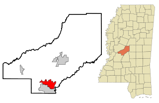
Madison is a city in Madison County, Mississippi, United States. The population was 24,841 at the 2010 census. The population is currently over 25,000. It is part of the Jackson Metropolitan Statistical Area.

Hattiesburg is a city in the U.S. state of Mississippi, primarily in Forrest County and extending west into Lamar County. The city population was 45,989 at the 2010 census, with an estimated population of 46,805 in 2015. It is the principal city of the Hattiesburg, Mississippi, Metropolitan Statistical Area, which encompasses Forrest, Lamar and Perry counties.
Crowley's Ridge is an unusual geological formation that rises 250 to 550 feet (170 m) above the alluvial plain of the Mississippi embayment in a 150-mile (240 km) line from southeastern Missouri to the Mississippi River near Helena, Arkansas. It is the most prominent feature in the Mississippi Alluvial Plain between Cape Girardeau, Missouri, and the Gulf of Mexico.

The Adirondack Park is a part of New York's Forest Preserve in northeastern New York, United States. The park's boundary corresponds with the Adirondack Mountains. Established in 1885, it was the first state preserve of its type in the nation. Unlike most preserves, about 52 percent of the land is privately owned inholdings heavily regulated by the Adirondack Park Agency. This area contains 102 towns and villages, as well as numerous farms, businesses, and an active timber harvesting industry. The year-round population is 132,000, with 200,000 seasonal residents. The inclusion of human communities makes the park one of the great experiments in conservation in the industrialized world. It was designated a National Historic Landmark in 1963.

Singletary Lake State Park is a North Carolina state park in Bladen County, North Carolina in the United States. Located near Elizabethtown, it covers 1,221-acre (4.94 km2), including Singletary Lake, one of the largest Carolina bays. Singletary Lake State Park is southeast of Elizabethtown on North Carolina Highway 53 in North Carolina's Coastal Plain region. It serves primarily as a group camp but is open on a limited basis for year-round recreation, including hiking, fishing and observing nature.

William B. Umstead State Park is a North Carolina state park in Wake County, North Carolina in the United States. It covers 5,599 acres (22.66 km2) nestled between the expanding cities of Raleigh, Cary, and Durham, North Carolina. It offers hiking, bridle, and bike trails, boat rentals, camping, picnic areas, and educational programs.

Congaree National Park is a 26,276-acre American national park in central South Carolina. The park received its official designation in 2003 as the culmination of a grassroots campaign that began in 1969. The park preserves the largest tract of old growth bottomland hardwood forest left in the United States. The lush trees growing in its floodplain forest are some of the tallest in the eastern United States, forming one of the highest temperate deciduous forest canopies remaining in the world. The Congaree River flows through the park. About 15,000 acres are designated as a wilderness area.

The protected areas of the United States are managed by an array of different federal, state, tribal and local level authorities and receive widely varying levels of protection. Some areas are managed as wilderness, while others are operated with acceptable commercial exploitation. As of 2015, the 25,800 protected areas covered 1,294,476 km2 (499,800 sq mi), or 14 percent of the land area of the United States. This is also one-tenth of the protected land area of the world. The U.S. also had a total of 787 National Marine Protected Areas, covering an additional 1,271,408 km2 (490,893 sq mi), or 12 percent of the total marine area of the United States.

Nathan Bedford Forrest State Park is a state park in Benton County, Tennessee, in the southeastern United States. The park is situated on the western shore of the Kentucky Lake impoundment of the Tennessee River, just north of the community of Eva. Established in 1929, the park consists of 2,587 acres (10.47 km2) managed by the Tennessee Department of Environment and Conservation.

The White Mountain National Forest (WMNF) is a federally managed forest contained within the White Mountains in the northeastern United States. It was established in 1918 as a result of the Weeks Act of 1911; federal acquisition of land had already begun in 1914. It has a total area of 750,852 acres (303,859 ha). Most of the WMNF is in New Hampshire; a small part is in the neighboring state of Maine. While often casually referred to as a park, this is a National Forest, used not only for hiking, camping, and skiing, but for logging and other limited commercial purposes. The WMNF is the only National Forest located in either New Hampshire or Maine. Most of the major peaks over 4,000 feet high for peak-bagging in New Hampshire are located in the National Forest. Over 100 miles (160 km) of the Appalachian Trail traverses the White Mountain National Forest. In descending order of land area the forest lies in parts of Grafton, Coos, and Carroll counties in New Hampshire, and Oxford County in Maine.

De Soto National Forest, named for 16th-century explorer Hernando de Soto, is 518,587 acres of pine forests in southern Mississippi. It is one of the most important protected areas for the biological diversity of the Gulf Coast ecoregion of North America.

Brooklyn is a small unincorporated community in southern Forrest County, Mississippi. It is part of the Hattiesburg, Mississippi Metropolitan Statistical Area.
Taconic State Park is located in Columbia and Dutchess County, New York abutting Massachusetts and Connecticut within the Taconic Mountains. The state park is located off New York State Route 344 south of Interstate 90 and 110 miles (180 km) north of New York City. It features camping, hiking, bicycling, hunting, cross county skiing and other recreational opportunities.

Prairie Creek Redwoods State Park is a state park, located in Humboldt County, California, near the town of Orick and 50 miles (80 km) north of Eureka. The 14,000 acre (57 km²) park is a coastal sanctuary for old-growth Coast Redwood trees.

The Tunxis Trail is a 79-mile (127 km) Blue-Blazed hiking trail "system" that traverses the western ridge of the central Connecticut Valley. The mainline trail is not completely contiguous, notably there are two gaps of several miles.
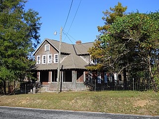
The New York Hotel is a historic hotel in Fruitland Park, Mississippi. Constructed in 1914, the building is a 1½ story, 12 bedroom, shingle-style structure containing 3600 square feet. It was added to the National Register of Historic Places in 1999.
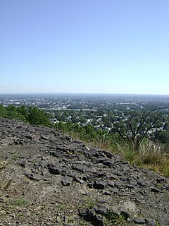
Rifle Camp Park is a 225-acre (0.9 km2) county park of Passaic County, New Jersey. It is located mostly within Woodland Park, but its eastern edge extends into Clifton as well. The park includes hiking trails, an observatory, nature center, fitness trail, amphitheater, a bird watching blind, and an overnight camping facility for local scout organizations.