Pyramid Lake is the geographic sink of the basin of the Truckee River, 40 mi (64 km) northeast of Reno, Nevada, United States.

The rainbow trout is a trout and species of salmonid native to cold-water tributaries of the Pacific Ocean in Asia and North America. The steelhead is an anadromous (sea-run) form of the coastal rainbow trout(O. m. irideus) or Columbia River redband trout (O. m. gairdneri) that usually returns to fresh water to spawn after living two to three years in the ocean. Freshwater forms that have been introduced into the Great Lakes and migrate into tributaries to spawn are also called steelhead.

The cutthroat trout(Oncorhynchus clarkii) is a fish species of the family Salmonidae native to cold-water tributaries of the Pacific Ocean, Rocky Mountains, and Great Basin in North America. As a member of the genus Oncorhynchus, it is one of the Pacific trout, a group that includes the widely distributed rainbow trout. Cutthroat trout are popular gamefish, especially among anglers who enjoy fly fishing. The common name "cutthroat" refers to the distinctive red coloration on the underside of the lower jaw. The specific name clarkii was given to honor explorer William Clark, coleader of the Lewis and Clark Expedition.

Lake Oroville is a reservoir formed by the Oroville Dam impounding the Feather River, located in Butte County, northern California. The lake is situated 5 miles (8.0 km) northeast of the city of Oroville, within the Lake Oroville State Recreation Area, in the western foothills of the Sierra Nevada. Known as the second-largest reservoir in California, Lake Oroville is treated as a keystone facility within the California State Water Project by storing water, providing flood control, recreation, freshwater releases assist in controlling the salinity intrusion Sacramento-San Joaquin Delta and protecting fish and wildlife.

The Spring River is a 129-mile-long (208 km) waterway located in southwestern Missouri, southeastern Kansas, and northeastern Oklahoma. The head of Spring River is a spring south of Verona just south of Highway 60 which crosses it, meanders through Verona northwest and turns west across Lawrence and Jasper counties. There used to be a trout farm at the head where the spring is. It passes through Carthage, before crossing into Cherokee County, Kansas, where it widens considerably. It flows past the east sides of Riverton and Baxter Springs before emptying into the Grand Lake o' the Cherokees in Ottawa County, Oklahoma.

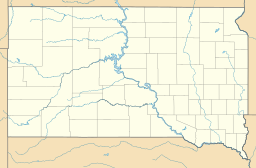
Lewis and Clark Lake is a 31,400 acre (130 km²) reservoir located on the border of the U.S. States of Nebraska and South Dakota on the Missouri River. The lake is approximately 25 miles (40 km) in length with over 90 miles (140 km) of shoreline and a maximum water depth of 45 feet (14 m). The lake is impounded by Gavins Point Dam and is managed by the U.S. Army Corps of Engineers, Omaha District.

The Missouri National Recreational River is a National Recreational River located on the border between Nebraska and South Dakota. The designation was first applied in 1978 to a 59-mile section of the Missouri River between Gavins Point Dam and Ponca State Park. In 1991, an additional 39-mile section between Fort Randall Dam and Niobrara, Nebraska, was added to the designation. These two stretches of the Missouri River are the only parts of the river between Montana and the mouth of the Missouri that remain undammed or unchannelized. The last 20 miles of the Niobrara River and 6 miles of Verdigre Creek were also added in 1991.
Redband trout are a group of three recognized subspecies of rainbow trout. They occur in three distinct regions in Pacific basin tributaries and endorheic basins in the western United States. The three subspecies are the Columbia River redband trout, the McCloud River redband trout and the Great Basin redband trout.
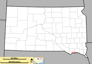
Karl E. Mundt National Wildlife Refuge is located mostly in the southern part of the U.S. state of South Dakota, with a small extension into northern Nebraska, and includes 1,085 acres (4.39 km2) The refuge is a part of the Lake Andes National Wildlife Refuge Complex and is managed by the U.S. Fish and Wildlife Service. Of the land area in the district, the U.S. Government owns only 780 acres (3.15 km2), while the remaining area is managed as an easement. The refuge is closed to the public but there are excellent viewing locations from the Ft. Randle Dam on the Missouri River. The Karl E. Mundt NWR has the largest concentration of bald eagles in the lower 48 states, with over 200 eagles often spending the winter on the refuge. The refuge was named for former South Dakota Senator Karl Mundt, who was a strong supporter of the Endangered Species Act of 1966.

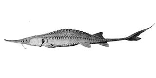
The bonytail chub or bonytail is a cyprinid freshwater fish native to the Colorado River basin of Arizona, California, Colorado, Nevada, New Mexico, Utah and Wyoming in the southwestern United States; it has been extirpated from the part of the basin in Mexico. It was once abundant and widespread in the basin, its numbers and range have declined to the point where it has been listed as endangered since 1980 (ESA) and 1986 (IUCN), a fate shared by the other large Colorado basin endemic fish species like the Colorado pikeminnow, humpback chub, and razorback sucker. It is now the rarest of the endemic big-river fishes of the Colorado River. There are 20 species in the genus Gila, seven of which are found in Arizona.

Lost Creek Lake is a reservoir located on the Rogue River in Jackson County, Oregon, United States. The lake is impounded by William L. Jess Dam which was constructed by the U.S. Army Corps of Engineers in 1977 for flood control and fisheries enhancement. The lake and dam were the first completed elements of the multi-purpose Rogue River Basin Project, consisting of Lost Creek Lake, Applegate Lake and the Elk Creek project. The lake is located approximately 27 miles (43 km) northeast of Medford.

Fish stocking is the practice of raising fish in a hatchery and releasing them into a river, lake, or ocean to supplement existing populations or to create a population where none exists. Stocking may be done for the benefit of commercial, recreational, or tribal fishing, but may also be done to restore or increase a population of threatened or endangered fish in a body of water closed to fishing.
Wolf Creek National Fish Hatchery is a National Fish Hatchery located just below Wolf Creek Dam in Russell County, Kentucky. The hatchery is a federal hatchery and is a part of the U.S. Fish and Wildlife Service.
The Neosho National Fish Hatchery is the oldest federal fish hatchery in operation today. It is one of 69 fish hatcheries operated by the US Fish and Wildlife Service. It was established in 1888.

The Bozeman National Fish Hatchery, now known as Bozeman Fish Technology Center, is located about 4 miles (6.4 km) northeast of Bozeman, Montana, at the entrance to Bridger Canyon. There is also a National Fish Health Center on the southwest side of Bozeman, near Montana State University, about 7 miles (11 km) away from the Fish Technology Center. Fish Technology Centers work with a wide variety of public and private partners to improve and conserve aquatic resources. Both the Fish Technology Center and the Fish Health Center are part of the National Fish Hatchery System, operated by the United States Fish and Wildlife Service. There are seven Fish Technology Centers and nine Fish Health Centers in the United States. The Bozeman hatchery is the fourth oldest National Fish Hatchery. The hatchery was named to the National Register of Historic Places on January 6, 1983.

The Montana Arctic grayling is a North American freshwater fish in the salmon family Salmonidae. The Montana Arctic grayling, native to the upper Missouri River basin in Montana and Wyoming, is a disjunct population or subspecies of the more widespread Arctic grayling. It occurs in fluvial and adfluvial, lacustrine forms. The Montana grayling is a species of special concern in Montana and had candidate status for listing under the national Endangered Species Act. It underwent a comprehensive status review by the U.S. Fish and Wildlife Service, which in 2014 decided not to list it as threatened or endangered. Current surviving native populations in the Big Hole River and Red Rock River drainages represent approximately four percent of the subspecies' historical range.
The Nimbus Fish Hatchery is located in eastern Sacramento County, built on the downstream side of the Nimbus Dam. It is one of the 21 fish hatcheries the California Department of Fish and Wildlife oversees. Chinook salmon and steelhead are raised, and about 4 million Chinook salmon and 430,000 steelhead released each year.

Lake Yankton, also called Cottonwood Lake, is an artificial lake that was originally part of the main channel of the Missouri River on the border of the U.S. States of Nebraska and South Dakota, near Yankton, South Dakota. The lake has an approximate surface area of 250 acres (100 ha) and has a maximum depth of 18 feet (5.5 m). The lake is located immediately downstream (east) of Gavins Point Dam and Lewis and Clark Lake, located just north of the current location of the main channel of the Missouri River.