Lakewood is a city in Cuyahoga County, Ohio, United States. It is part of the Greater Cleveland Metropolitan Area, and borders the city of Cleveland. The population was 52,131 at the 2010 United States Census, making it the third largest city in Cuyahoga County, behind Cleveland (396,815) and Parma (81,601).

Cuyahoga Valley National Park is an American national park that preserves and reclaims the rural landscape along the Cuyahoga River between Akron and Cleveland in Northeast Ohio. Cuyahoga Valley is unusual among American national parks being adjacent to two large urban areas and including a dense road network, small towns, and private attractions.

Parks in Chicago include open spaces and facilities, developed and managed by the Chicago Park District. The City of Chicago devotes 8.5% of its total land acreage to parkland, which ranked it 13th among high-density population cities in the United States in 2012. Since the 1830s, the official motto of Chicago has been Urbs in horto, Latin for "City in a garden" for its commitment to parkland. In addition to serving residents, a number of these parks also double as tourist destinations, most notably Lincoln Park, Chicago's largest park, visited by over 20 million people each year, is one of the most visited parks in the United States. Notable architects, artists and landscape architects have contributed to the 570 parks, including Daniel Burnham, Frederick Law Olmsted, Jens Jensen, Dwight Perkins, Frank Gehry, and Lorado Taft.
The Blackfeet Nation also known as the Blackfeet Tribe of the Blackfeet Indian Reservation is an Indian reservation and headquarters for the Siksikaitsitapi people in the United States. Located in Montana, its members are composed primarily of the Piegan Blackfeet band of the larger ethnic group historically described as the Blackfoot Confederacy. It is located east of Glacier National Park and borders the Canadian province of Alberta. Cut Bank Creek and Birch Creek form part of its eastern and southern borders. The reservation contains 3,000 square miles (7,800 km2), twice the size of the national park and larger than the state of Delaware. It is located in parts of Glacier and Pondera counties.
Irishtown Bend is the name given to both a former Irish American neighborhood and a landform located on the Flats of the west bank of the Cuyahoga River in the city of Cleveland in the U.S. state of Ohio in the United States. The landform consists of a tight meander in the Cuyahoga River, and the steep hillside above this meander.

Squire's Castle is a shell of a building located in the North Chagrin Reservation of the Cleveland Metroparks in Willoughby Hills, Ohio. It is allegedly haunted, although the story explaining why it is haunted is false.

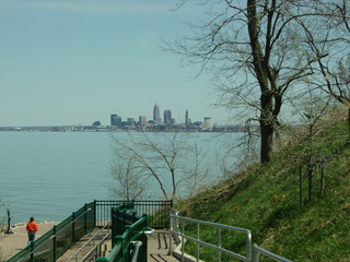
Downtown Cleveland is the central business district of Cleveland, Ohio. It is the economic and symbolic center of the Cleveland-Akron-Canton, OH Combined Statistical Area.
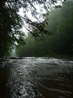
Tinker's Creek, in Cuyahoga, Summit and Portage counties, is the largest tributary of the Cuyahoga River, providing about a third of its flow into Lake Erie.

Old Brooklyn is a west side neighborhood of Cleveland, Ohio, United States, located approximately five miles south of downtown Cleveland. It extends east-to-west from the Cuyahoga River to the city of Brooklyn and north-to-south from the Brookside Park Valley to the city of Parma.

Cleveland Burke Lakefront Airport is a public airport on the shore of Lake Erie, in the northeast part of downtown Cleveland, Ohio, United States. It classified as a general aviation airport and is an FAA designated reliever to Cleveland Hopkins International Airport (CLE), which is Greater Cleveland's primary airport. In 2008, based on FAA data, Burke Lakefront was the fourth busiest airport in the state of Ohio after Cleveland Hopkins, John Glenn Columbus International and Akron-Canton, up from 7th in 2007. It is named after former Cleveland mayor and U.S. senator Thomas A. Burke.
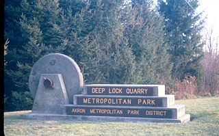
Cleveland Metroparks is an extensive system of nature preserves in Greater Cleveland, Ohio. Eighteen reservations, which largely encircle the city of Cleveland, following along some shores of Lake Erie and the rivers and creeks that flow through the region. Referred to unofficially as the 'Emerald Necklace', the network of parks spans over 23,000 acres (9,300 ha) and includes over 300 miles (480 km) of walking, bicycle, and horse trails as well as numerous picnic areas, nature education centers, golf courses, and countless fishing spots. In addition, the district includes the zoo in Cleveland. Several of the reservations are adjacent to Cuyahoga Valley National Park.
Summit Metro Parks is a Metroparks system serving the citizens of Summit County, Ohio by managing 14,100 acres (5,700 ha) in 16 developed parks, six conservation areas and more than 125 miles (201 km) of trails, with 22.4 miles (36.0 km) of the Ohio & Erie Canal Towpath Trail.

North Coast Harbor is a district in downtown Cleveland, Ohio on the shore of Lake Erie. The district serves as the home of the Great Lakes Science Center, the Rock and Roll Hall of Fame and Museum, FirstEnergy Stadium, the Steamship William G. Mather Maritime Museum, the USS Cod, Burke Lakefront Airport, Voinovich Bicentennial Park, and the Cleveland-Cuyahoga County Port Authority. It is served by the West 3rd and North Coast stations on RTA's light rail Waterfront Line.

DuSable Park is a former commercial and industrial site, at the mouth of the Chicago River that has been the subject of environmental remediation and is awaiting redevelopment into a park. The project, first announced in 1987 by Mayor Harold Washington, is named in honor Jean Baptiste Point du Sable, who settled nearby in the 1780s and is known as the "Founder of Chicago".

Glenville is a neighborhood on the east side of Cleveland, Ohio. The neighborhood has an irregular border. It begins in the northeast at Eddy Road, and follows Hazeldell Road, E. 110th Street, and Lakeview Road south to E. 114th Street. It follows E. 114th Street South to Superior Avenue, where the border moves east to E. 125th Street. It follows E. 125th Street south to Hower Avenue, and then cuts across residential blocks in a due-south line to Wade Park Avenue. It roughly follows Wade Park Avenue west to E. 105th Street, then E. 105th Street north to Superior Avenue. It follows Superior Avenue west to E. 98th Street. The border follows Parkgate Avenue west, cuts across Rockefeller Park to Crumb Avenue, and then follows Crumb Avenue, E. 79th Street, and St. Clair Avenue to E. 72nd Street. After following E. 72nd Street north to the Lake Erie shore, it follows the shore to encompass the Cleveland Lakefront Nature Preserve before moving due south inland to the Cleveland Memorial Shoreway. The border then follows the Shoreway to Eddy Road.

Detroit–Shoreway is a neighborhood on the West Side of Cleveland, in the U.S. state of Ohio. Detroit–Shoreway consists of the streets between Lake Erie and Interstate 90, from West 85th to West 45th streets.

Whiskey Island is a peninsula at the mouth of the Cuyahoga River at Lake Erie in Cleveland, Ohio. Its current configuration was created in 1827 when the river's mouth was moved to its present location. The western half of Whiskey Island is occupied by the Cleveland Bulk Terminal and the eastern section is home to a marina and public park. It is one mile long and one-third mile at its widest, bounded by Lake Erie to the north, West 54th Street on the west (roughly), and the Cuyahoga River to the south and east.
Rockefeller Park is a city park named in honor of oil magnate John D. Rockefeller Sr., located in Cleveland, Ohio. Part of the Cleveland Public Parks District, Rockefeller Park is immediately adjacent Wade Park to the southeast, and across Euclid Ave on its northwest border. Besides the distinction of being the largest park located completely within city limits, Rockefeller Park is a link in a chain of parkland that connects the heights region of the eastern suburbs to the city's lakefront. Following the path of Martin Luther King Jr. Drive and spanning a large section of Cleveland's East Sides, the park runs in a northwesterly path between suburban Shaker Heights, bisecting the University Circle neighborhood and terminating at Gordon Park on the city's lakefront, opened to the public in 1897. The park was dramatically expanded during the 1930s with labor provided by the Works Progress Administration. Landmarks found in Rockefeller Park include two separate entries on the National Register of Historic Places: one for its architecturally historic bridges, and one for its Cultural Gardens.
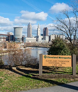
The Cleveland Foundation Centennial Lake Link Trail, originally known as the Lake Link Trail, is a cycling, hiking, and walking trail located in the city of Cleveland, Ohio, in the United States. Owned by the city of Cleveland and maintained by Cleveland Metroparks, the trail runs along the former track bed of the Cleveland and Mahoning Valley Railroad. The trail is named for The Cleveland Foundation, a local community foundation which donated $5 million toward the trail's construction. The southern leg of the 1.3-mile (2.1 km) trail opened in August 2015, and the northern leg in August 2017. The middle leg will begin construction once the Irishtown Bend hillside is stabilized. A bridge connecting the trail to Whiskey Island will begin construction in Spring 2019 and will be completed in early Summer 2020.

Euclid Creek is a 43-mile (69 km) long stream located in Cuyahoga and Lake counties in the state of Ohio in the United States. The 11.5-mile (18.5 km) long main branch runs from the Euclid Creek Reservation of the Cleveland Metroparks to Lake Erie. The west branch is usually considered part of the main branch, and extends another 16 miles (26 km) to the creek's headwaters in Beachwood, Ohio. The east branch runs for 19 miles (31 km) and has headwaters in Willoughby Hills, Ohio.


