
In earth science, erosion is the action of surface processes that removes soil, rock, or dissolved material from one location on the Earth's crust, and then transports it to another location. This natural process is caused by the dynamic activity of erosive agents, that is, water, ice (glaciers), snow, air (wind), plants, animals, and humans. In accordance with these agents, erosion is sometimes divided into water erosion, glacial erosion, snow erosion, wind (aeolic) erosion, zoogenic erosion, and anthropogenic erosion. The particulate breakdown of rock or soil into clastic sediment is referred to as physical or mechanical erosion; this contrasts with chemical erosion, where soil or rock material is removed from an area by its dissolving into a solvent, followed by the flow away of that solution. Eroded sediment or solutes may be transported just a few millimetres, or for thousands of kilometres.

Marl or marlstone is a calcium carbonate or lime-rich mud or mudstone which contains variable amounts of clays and silt. The dominant carbonate mineral in most marls is calcite, but other carbonate minerals such as aragonite, dolomite, and siderite may be present. Marl was originally an old term loosely applied to a variety of materials, most of which occur as loose, earthy deposits consisting chiefly of an intimate mixture of clay and calcium carbonate, formed under freshwater conditions; specifically an earthy substance containing 35–65% clay and 65–35% carbonate. It also describes a habit of coralline red alga. The term is today often used to describe indurated marine deposits and lacustrine (lake) sediments which more accurately should be named 'marlstone'. Marlstone is an indurated rock of about the same composition as marl, more correctly called an earthy or impure argillaceous limestone. It has a blocky subconchoidal fracture, and is less fissile than shale. The term 'marl' is widely used in English-language geology, while the terms Mergel and Seekreide are used in European references.
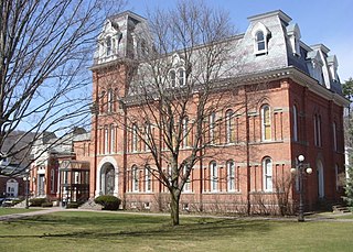
Delaware County is a county located in the US state of New York. As of 2010 the population was 47,980. The county seat is Delhi. The county is named after the Delaware River, which was named in honor of Thomas West, 3rd Baron De La Warr, appointed governor of Virginia in 1609.

Greenwich is a town in Fairfield County, Connecticut, United States. As of the 2010 census, the town had a total population of 61,171. It is the 10th largest municipality in Connecticut, and the largest that functions as a town.

Alluvium is loose, unconsolidated soil or sediment that has been eroded, reshaped by water in some form, and redeposited in a non-marine setting. Alluvium is typically made up of a variety of materials, including fine particles of silt and clay and larger particles of sand and gravel. When this loose alluvial material is deposited or cemented into a lithological unit, or lithified, it is called an alluvial deposit.
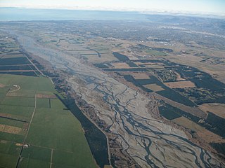
An alluvial plain is a largely flat landform created by the deposition of sediment over a long period of time by one or more rivers coming from highland regions, from which alluvial soil forms. A floodplain is part of the process, being the smaller area over which the rivers flood at a particular period of time, whereas the alluvial plain is the larger area representing the region over which the floodplains have shifted over geological time.
Interstate 295 (I-295) in Delaware, New Jersey, and Pennsylvania is an auxiliary Interstate Highway, designated as a bypass around Philadelphia and a partial beltway of Trenton, New Jersey. The route begins at a junction with I-95 south of Wilmington, Delaware, and runs to an interchange with I-95 in Bristol Township, Pennsylvania. The highway heads east from I-95 and crosses the Delaware River from Delaware to New Jersey on the Delaware Memorial Bridge concurrent with U.S. Route 40. Upon entering New Jersey, I-295 splits from the New Jersey Turnpike and US 40, and runs parallel to the Turnpike for most of its course in the state. After a concurrency with US 130 in Gloucester County, I-295 has an interchange with I-76 and Route 42 in Camden County. The freeway continues northeast toward Trenton, where it intersects I-195 and Route 29 before bypassing the city to the east, north, and west, crossing the Delaware River on the Scudder Falls Bridge into Pennsylvania. In Pennsylvania, I-295 is signed as an east-west road and heads south to its western terminus at I-95.

Delaware Route 1 (DE 1) is a 103.02-mile-long (165.79 km) state highway in the U.S. state of Delaware. The route runs from the Maryland border in Fenwick Island, Sussex County, where it continues south into that state as Maryland Route 528 (MD 528), north to an interchange with DE 58 in Christiana, New Castle County, where the road continues north as DE 7. Between Fenwick Island and Dover Air Force Base in Dover, Kent County, DE 1 is a four- to six-lane surface divided highway with occasional interchanges. The route heads north past the Delaware Beaches along the Atlantic Ocean before it runs northwest through rural areas, turning north at Milford to continue to Dover. Upon reaching Dover, DE 1 becomes the Korean War Veterans Memorial Highway, a four- to six-lane freeway that is tolled. Between Dover and Tybouts Corner, DE 1 parallels U.S. Route 13 (US 13), crossing over and featuring interchanges with it multiple times. Past Tybouts Corner, the freeway heads north to Christiana, reaching an interchange with Interstate 95 (I-95) a short distance before its terminus. DE 1 serves as the main north-south state route in Delaware, connecting the Delaware Beaches with the Dover and Wilmington areas.
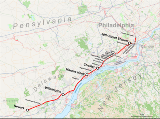
The Wilmington/Newark Line is a route of the SEPTA Regional Rail commuter rail system in the Philadelphia area. The line serves southeastern Pennsylvania and northern Delaware, with stations in Marcus Hook, Pennsylvania, Wilmington, Delaware, and Newark, Delaware. It is the longest of the 13 SEPTA Regional Rail lines.
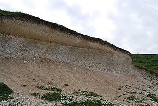
Calcareous is an adjective meaning "mostly or partly composed of calcium carbonate", in other words, containing lime or being chalky. The term is used in a wide variety of scientific disciplines.

The Ogeechee River is a 294-mile-long (473 km) blackwater river in the U.S. state of Georgia. It heads at the confluence of its North and South Forks, about 2.5 miles (4.0 km) south-southwest of Crawfordville and flowing generally southeast to Ossabaw Sound about 16 miles (26 km) south of Savannah. Its largest tributary is the Canoochee River, which drains approximately 1,400 square miles (3,600 km2) and is the only other major river in the basin. The Ogeechee has a watershed of 5,540 square miles (14,300 km2). It is one of the state's few free-flowing streams.

New Jersey is a state within the United States of America that lies on the north eastern edge of the North American continent. It shares a land border with the state of State of New York along the north, ratified by both states after the New York – New Jersey Line War. New Jersey is slightly larger than the country of Kuwait.

The Geology of Pennsylvania consists of six distinct physiographic provinces, three of which are subdivided into different sections. Each province has its own economic advantages and geologic hazards and plays an important role in shaping everyday life in the state. They are: the Atlantic Coastal Plain Province, the Piedmont Province, the New England Province, the Ridge and Valley Province, the Appalachian Plateau Province, and the Central Lowlands Province.

Chapman River is a river in the Mid West region of Western Australia.
Mahantango Creek is a 2.1-mile-long (3.4 km) tributary of the Susquehanna River in Snyder and Juniata counties, Pennsylvania, in the United States. Its name comes from a Delaware Indian word meaning "where we had plenty to eat". The creek flows along the border between Snyder County and Juniata County.

Mugser Run is a 8.0-mile-long (12.9 km) stream in Columbia County, Pennsylvania, in the United States. It is a tributary of South Branch Roaring Creek. Mugser Run is located in Locust and Cleveland Townships. Forested land and agricultural land are by far the most common uses of land in the watershed. Brown trout and rainbow trout are found in the creek. The main rock formations are the Trimmers Rock Formation and the Catskill Formation–Buddys Run formation.

The Delaware State Route System consists of roads in the U.S. state of Delaware that are maintained by the Delaware Department of Transportation (DelDOT). The system includes the portions of the Interstate Highway System and United States Numbered Highways system located in the state along with state routes and other roads maintained by DelDOT. All roads maintained by the state are assigned a maintenance road number that is only marked on little white markers at intersections and on auxiliary plates below warning signs approaching intersections. These numbers are only unique in a specific county, some roads can be designated with multiple road numbers, and numbers do not necessarily correspond to the signed Interstate, U.S., or state route numbers. DelDOT maintains a total of 5,386.14 miles (8,668.15 km) of roads, comprising 89 percent of the roads within the state. Some large bridges in the state are maintained by other agencies including the U.S. Army Corps of Engineers and the Delaware River and Bay Authority. Roads in the system include multilane freeways, multilane surface divided highways, and two-lane undivided roads serving urban, suburban, and rural areas. Some of the roads maintained by DelDOT are toll roads, in which motorists must pay to use.
The geology of Rhode Island is based on nearly one billion year old igneous crystalline basement rocks formed as part of the microcontinent Avalonia that collided with the supercontinent Gondwana. The region experienced substantial folding associated with its landlocked position during the Alleghanian orogeny mountain building event. The region accumulated sedimentary rocks, including small deposits of coal. The region was covered with thick Atlantic Coastal Plain sediments, with the erosion of the Appalachians and the creation of the Atlantic Ocean throughout the past 200 million years. These surficial sediments and soils were substantially reworked by the Pleistocene glaciations. The state's geology is part of the broader geology of New England.
