Gull Island is a small island in the Churchill river in Labrador, in the Province of Newfoundland and Labrador, Canada.
52°57′54.21″N61°22′23.77″W / 52.9650583°N 61.3732694°W
Gull Island is a small island in the Churchill river in Labrador, in the Province of Newfoundland and Labrador, Canada.
52°57′54.21″N61°22′23.77″W / 52.9650583°N 61.3732694°W


The Gulf of St. Lawrence is the outlet of the North American Great Lakes via the St. Lawrence River into the Atlantic Ocean. The gulf is a semi-enclosed sea, covering an area of about 226,000 square kilometres (87,000 sq mi) and containing about 34,500 cubic kilometres (8,300 cu mi) of water, at an average depth of 152 metres (500 ft).

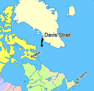
Davis Strait is a northern arm of the Atlantic Ocean that lies north of the Labrador Sea. It lies between mid-western Greenland and Baffin Island in Nunavut, Canada. To the north is Baffin Bay. The strait was named for the English explorer John Davis (1550–1605), who explored the area while seeking a Northwest Passage. By the 1650s it was used for whale hunting.

The Labrador Sea is an arm of the North Atlantic Ocean between the Labrador Peninsula and Greenland. The sea is flanked by continental shelves to the southwest, northwest, and northeast. It connects to the north with Baffin Bay through the Davis Strait. It is a marginal sea of the Atlantic.
Newfoundland and Labrador Hydro, commonly known as Hydro, is a provincial Crown corporation that generates and delivers electricity for Newfoundland and Labrador, as well as portions of Quebec and the north-eastern areas of the United States. Between 2007 and 2021, NL Hydro was a subsidiary of the provincial Crown-owned energy holding company Nalcor Energy.

Grates Cove is a local service district and designated place in the Canadian province of Newfoundland and Labrador. It is the most northerly community on the Avalon Peninsula, located on the tip of the Bay de Verde Peninsula on the island of Newfoundland. Called "the Grates" by John Guy as early as 1612, the origin of the name is unknown.
The Bay de Verde Peninsula is the largest peninsula that makes up part of the Avalon Peninsula, of the province of Newfoundland and Labrador, Canada. The peninsula separates both Trinity and Conception Bay.
Cape St. John is a headland located on the north coast of Newfoundland in the Canadian province of Newfoundland and Labrador.

Route 460 is a 87.5-kilometre-long (54.4 mi) east-west Canadian provincial highway in Newfoundland and Labrador.
Charlottetown is a town in Labrador with a population of 292 in the Canadian province of Newfoundland and Labrador. It was said to be founded by Benjamin Powell in 1950 and named for Charlottetown, Prince Edward Island: "I thought that maybe someday the place would be the capital of the bay, the same way Charlottetown is the capital of Prince Edward Island."
Greenly Island is an island in Blanc-Sablon, Quebec, Canada, near the border of Newfoundland and Labrador, in the Gulf of Saint Lawrence at the southwestern end of Strait of Belle Isle. The rocky surface of Greenly Island has a thin cover of herbaceous vegetation. A fishing settlement and lighthouse are on the island.
Cape Freels is a headland on the island of Newfoundland, in the province of Newfoundland and Labrador, Canada, and the location of a community of the same name. This cape, located at the northern extremity of Bonavista Bay, is not to be confused with another Cape Freels which is located at the southern extremity of the Avalon Peninsula of Newfoundland.

Wabana is a Canadian town and the largest, and only incorporated, community on Bell Island in the province of Newfoundland and Labrador.
Deep Bay is a designated place in the Canadian province of Newfoundland and Labrador.
Lord's Cove is a town in the Canadian province of Newfoundland and Labrador. The town had a population of 155 in the Canada 2021 Census. Lord's Cove has a rich inshore fishing history and heritage. The town is approximately 65 km southeast of Marystown.
Lance Cove, Newfoundland and Labrador is a local service district and designated place in the Canadian province of Newfoundland and Labrador.

Division No. 1, Subdivision G is an unorganized subdivision on the Avalon Peninsula in Newfoundland and Labrador, Canada. It is in Division 1 and contains the unincorporated communities of Baccalieu Island, Besom Cove, Bradley's Cove, Burnt Point, Caplin Cove, Daniel's Cove, Grates Cove, Gull Island, Job's Cove, Kingston, Long Beach, Lower Island Cove, Low Point, Northern Bay, Ochre Pit Cove, Red Head Cove, Riverhead, Smooth Cove and Western Bay.
Burnt Point-Gull Island-Northern Bay is a local service district and designated place in the Canadian province of Newfoundland and Labrador.