Gyeongju Basin

Last updated
Gyeongju Basin
Hangul 경주분지
Hanja
Revised Romanization Gyeongju-bunji
McCune–Reischauer Kyŏngju punji

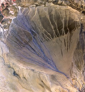
The Gyeongju Basin is a landform in Gyeongju city, North Gyeongsang province, South Korea. It forms part of the watershed of the Hyeongsan River, which flows north through the basin where it is joined by the Bukcheon, Namcheon, Daecheon, and Sogyeon-cheon streams.

Landform A natural feature of the solid surface of the Earth or other planetary body

A landform is a natural feature of the solid surface of the Earth or other planetary body. Landforms together make up a given terrain, and their arrangement in the landscape is known as topography. Typical landforms include hills, mountains, plateaus, canyons, and valleys, as well as shoreline features such as bays, peninsulas, and seas, including submerged features such as mid-ocean ridges, volcanoes, and the great ocean basins.

Gyeongju Municipal City in North Gyeongsang Province, South Korea

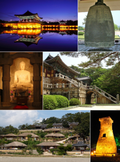
Gyeongju, historically known as Seorabeol, is a coastal city in the far southeastern corner of North Gyeongsang Province in South Korea. It is the second largest city by area in the province after Andong, covering 1,324 km2 (511 sq mi) with a population of 264,091 people Gyeongju is 370 km (230 mi) southeast of Seoul, and 55 km (34 mi) east of Daegu. The city borders Cheongdo and Yeongcheon to the west, Ulsan to the south and Pohang to the north, while to the east lies the coast of the Sea of Japan. Numerous low mountains—outliers of the Taebaek range—are scattered around the city.

South Korea Republic in East Asia

South Korea, officially the Republic of Korea (ROK), is a country in East Asia, constituting the southern part of the Korean Peninsula and lying to the east of the Asian mainland. The name Korea is derived from Goguryeo which was one of the great powers in East Asia during its time, ruling most of the Korean Peninsula, Manchuria, parts of the Russian Far East and Inner Mongolia, under Gwanggaeto the Great. South Korea lies in the north temperate zone and has a predominantly mountainous terrain. It comprises an estimated 51.4 million residents distributed over 100,363 km2 (38,750 sq mi). Its capital and largest city is Seoul, with a population of around 10 million.

Contents

The basin is surrounded by low mountains, most of which are also part of Gyeongju National Park. Specifically, it is bordered by Gowi Mountain (495 m above sea level) on the south, Seondo Mountain (380 m) and Ongnyeo Peak (215 m) on the west, and Gumi Mountain (594 m) on the north. Namsan, a mountain composed of two peaks (466 m, 495 m), cuts the Gyeongju Basin into two parts at the southern end. The streams that flow from these mountains have formed a number of interlinked alluvial plains in the Basin.

Mountain A large landform that rises fairly steeply above the surrounding land over a limited area

A mountain is a large landform that rises above the surrounding land in a limited area, usually in the form of a peak. A mountain is generally steeper than a hill. Mountains are formed through tectonic forces or volcanism. These forces can locally raise the surface of the earth. Mountains erode slowly through the action of rivers, weather conditions, and glaciers. A few mountains are isolated summits, but most occur in huge mountain ranges.

Gyeongju National Park national park

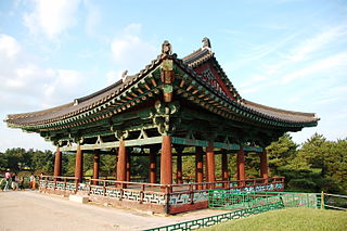
Gyeongju National Park is located in the province of Gyeongsangbuk-do, South Korea, and is the country's only historical national park. It was first designated a national park in 1968. The park covers many of the principal Silla historical sites in Gyeongju City. It is divided into several non-contiguous sections: Gumisan and Danseoksan sections to the west of the city center; Hwarang, Seo-ak, Sogeumgang, and Namsan sections in the heart of Gyeongju; Tohamsan section to the east, and Daebon section on the coast of the Sea of Japan.

Sea level Average level for the surface of the ocean at any given geographical position on the planetary surface

Mean sea level (MSL) is an average level of the surface of one or more of Earth's oceans from which heights such as elevation may be measured. MSL is a type of vertical datum – a standardised geodetic datum – that is used, for example, as a chart datum in cartography and marine navigation, or, in aviation, as the standard sea level at which atmospheric pressure is measured to calibrate altitude and, consequently, aircraft flight levels. A common and relatively straightforward mean sea-level standard is the midpoint between a mean low and mean high tide at a particular location.

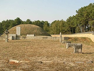
The city center of Gyeongju, which was also the capital of the ancient Silla kingdom, occupies much of the basin. Various watershed management projects were undertaken even during Silla times, due to continuous flooding in the basin, caused by runoff from the neighboring mountains combined with inflow from the upper Hyeongsan River watershed. The most recent severe flood took place in 1991.

Silla Old kingdom of Korea

Silla was a kingdom located in southern and central parts of the Korean Peninsula. Silla, along with Baekje and Goguryeo, formed the Three Kingdoms of Korea.

Flood Overflow of water that submerges land that is not normally submerged

A flood is an overflow of water that submerges land that is usually dry. In the sense of "flowing water", the word may also be applied to the inflow of the tide. Floods are an area of study of the discipline hydrology and are of significant concern in agriculture, civil engineering and public health.

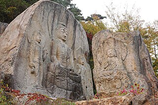
The basin is also home to a great number of important Korean cultural heritage assets, mostly related to its ancient role as capital of Silla. For example, the royal tombs of Silla are located there, as is the Gyerim forest. The slopes of the entire Namsan Mountain are covered in religious and ceremonial sites dating from the Mumun Pottery Period (c. 1500-300 B.C.) to the end of the Korean Three Kingdoms (c. AD 668). Namsan and environs is registered as a UNESCO World Heritage Site.

Korea Region in East Asia

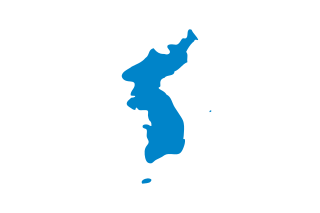
Korea is a region in East Asia. Since 1948, it has been divided between two distinct sovereign states: North Korea and South Korea. Korea consists of the Korean Peninsula, Jeju Island, and several minor islands near the peninsula. Korea is bordered by China to the northwest, Russia to the northeast, and neighbours Japan to the east by the Korea Strait and the Sea of Japan.

Tomb burial place

A tomb is a repository for the remains of the dead. It is generally any structurally enclosed interment space or burial chamber, of varying sizes.

Forest dense collection of trees covering a relatively large area

A forest is a large area dominated by trees. Hundreds of more precise definitions of forest are used throughout the world, incorporating factors such as tree density, tree height, land use, legal standing and ecological function. According to the widely used Food and Agriculture Organization definition, forests covered 4 billion hectares (9.9×10⁹ acres) (15 million square miles) or approximately 30 percent of the world's land area in 2006.

Agriculture is also undertaken on a significant scale within the basin. The crops are primary staples such as rice, barley, and soybeans. The Gyeongju strain of rice grown here is particularly famous for its quality. However, the Gyeongju Basin has undergone significant environmental strain since the 1970s resulting the construction of tourist facilities, the expansion and industrialization of urban Gyeongju, intensive agriculture, and the construction and use of national public infrastructure such as expressways, highways, and high-speed rail.

Agriculture Cultivation of plants and animals to provide useful products

Agriculture is the science and art of cultivating plants and livestock. Agriculture was the key development in the rise of sedentary human civilization, whereby farming of domesticated species created food surpluses that enabled people to live in cities. The history of agriculture began thousands of years ago. After gathering wild grains beginning at least 105,000 years ago, nascent farmers began to plant them around 11,500 years ago. Pigs, sheep and cattle were domesticated over 10,000 years ago. Plants were independently cultivated in at least 11 regions of the world. Industrial agriculture based on large-scale monoculture in the twentieth century came to dominate agricultural output, though about 2 billion people still depended on subsistence agriculture into the twenty-first.

Rice cereal grain and seed of Oryza sativa

Rice is the seed of the grass species Oryza sativa or Oryza glaberrima. As a cereal grain, it is the most widely consumed staple food for a large part of the world's human population, especially in Asia. It is the agricultural commodity with the third-highest worldwide production, after sugarcane and maize.

Barley Species of plant

Barley, a member of the grass family, is a major cereal grain grown in temperate climates globally. It was one of the first cultivated grains, particularly in Eurasia as early as 10,000 years ago. Barley has been used as animal fodder, as a source of fermentable material for beer and certain distilled beverages, and as a component of various health foods. It is used in soups and stews, and in barley bread of various cultures. Barley grains are commonly made into malt in a traditional and ancient method of preparation.

See also

Geography of South Korea

South Korea is located in East Asia, on the southern half of the Korean Peninsula jutting out from the far east of the Asian landmass. The only country with a land border to South Korea is North Korea, lying to the north with 238 kilometres (148 mi) of border running along the Korean Demilitarized Zone. South Korea is mostly surrounded by water and has 2,413 kilometres (1,499 mi) of coastline along three seas; to the west is the Yellow Sea, to the south is the East China Sea, and to the east is the Sea of Japan. Geographically, South Korea's land mass is approximately 100,032 square kilometres (38,623 sq mi). 290 square kilometres (110 sq mi) of South Korea are occupied by water. The approximate coordinates are 37° North, 127° 30 East.

Related Research Articles

Floodplain Land adjacent to a stream or river which is flooded during periods of high discharge

A floodplain or flood plain is an area of land adjacent to a stream or river which stretches from the banks of its channel to the base of the enclosing valley walls, and which experiences flooding during periods of high discharge. The soils usually consist of levees, silts, and sands deposited during floods. Levees are the heaviest materials and they are deposited first; silts and sands are finer materials.

Alluvial fan A fan- or cone-shaped deposit of sediment crossed and built up by streams

Alluvial fans are triangular-shaped deposits of water-transported material, often referred to as alluvium. They are an example of an unconsolidated sedimentary deposit and tend to be larger and more prominent in arid to semi-arid regions. These alluvial fans typically form in elevated or even mountainous regions where there is a rapid change in slope from a high to low gradient. The river or stream carrying the sediment flows at a relatively high velocity due to the high slope angle which is why coarse material is able to remain in the flow. When the slope decreases rapidly into a relatively plain or plateau, the stream loses the energy it needs to move its sediment. Deposition subsequently occurs and the sediment ultimately spreads out, creating an alluvial fan. Three primary zones occur within an alluvial fan which includes the proximal fan, medial fan, and the distal fan.

Three Kingdoms of Korea Period of Korean history, where three kingdoms (Goguryeo, Baekje, and Silla) coexisted on the Korean peninsula

The concept of the Three Kingdoms of Korea refers to the three kingdoms of Baekje, Silla and Goguryeo. Goguryeo was later known as Goryeo, from which the modern name Korea is derived. The Three Kingdoms period was defined as being from 57 BC to 668 AD.

Geum River river in South Korea

The Geum River is located in South Korea. It is a major river that originates in Jangsu-eup, North Jeolla Province. It flows northward through North Jeolla and North Chungcheong Provinces and then changes direction in the vicinity of Greater Daejeon and flows southwest through South Chungcheong Province before emptying into the Yellow Sea near Gunsan city.

Seokguram Cave in South Korea

The Seokguram Grotto is a hermitage and part of the Bulguksa temple complex. It lies four kilometers east of the temple on Mt. Tohamsan, in Gyeongju, South Korea. It is classified as National Treasure No. 24 by the South Korean government and is located at 994, Jinhyeon-dong, Gyeongju-si, Gyeongsanbuk-do. The grotto overlooks the Sea of Japan and rests 750 meters above sea level. In 1962, it was designated the 24th national treasure of Korea. In 1995, Seokguram was added to the UNESCO World Heritage List together with the Bulguksa Temple. It exemplifies some of the best Buddhist sculptures in the world.

Santa Ana River river in California, United States

The Santa Ana River is the largest river entirely within Southern California in the United States. It rises in the San Bernardino Mountains and flows for most of its length through San Bernardino and Riverside Counties, before cutting through the northern Santa Ana Mountains via Santa Ana Canyon and flowing southwest through urban Orange County to drain into the Pacific Ocean. The Santa Ana River is 96 miles (154 km) long, and its drainage basin is 2,650 square miles (6,900 km2) in size.

Sangju Municipal City in Yeongnam, South Korea

Sangju is a city in North Gyeongsang Province, South Korea. Although Sangju is rather rural, it is very old and was once a key city. Along with Gyeongju, it gives rise to half of the name of the Gyeongsang provinces. Sangju is nicknamed Sam Baek, or "Three Whites", referring to three prominent agricultural products rice, silkworm cocoons, and dried persimmons from the area.

Nakdong River river in South Korea

The Nakdong River or Nakdonggang is the longest river in South Korea, and passes through major cities such as Daegu and Busan. It takes its name from its role as the eastern border of the Gaya confederacy during Korea's Three Kingdoms Era.

Hyeongsan River river in southeastern South Korea

The Hyeongsan River is a river in southeastern South Korea. It flows from Baeyanggol Valley (배양골), Wolpyeong-ri (월평리/月坪里), Dudong-myeon (두동면/斗東面), Ulju County in Ulsan to the Sea of Japan, covering a distance of about 62 km. The Hyeongsan watershed covers roughly 1,167 km².

The Dongdae Mountains are a small outlying range of the Taebaek Mountains. They run along the east coast of South Korea through the cities of Pohang, Gyeongju, and Ulsan. Notable peaks include Toham Mountain in Gyeongju National Park, as well as Dongdae Mountain itself in Ulsan. The Dongdae Mountains separate the Hyeongsan River basin from the belt of small streams flowing directly into the Sea of Japan.

The primary subdivisions of Gyeongju in South Korea consist of 4 eup, 8 myeon, and 11 dong. These units are the same into which all of the cities and counties of South Korea are divided. The dong units occupy the area of the city center, which was formerly occupied by Gyeongju-eup. Eup refers to a substantial village, whereas the myeon are more rural. The current divisions are as follows, using the numbers given on the map:

Tohamsan mountain

Toham Mountain or Toham-san is a mountain with a height of 745 m (2,444 ft) in Gyeongju City in southeastern South Korea. It is part of the minor Dongdae Mountains range. The mountain lies within Gyeongju National Park and is the site of a large number of historic relics. The Silla-era Buddhist shrines of Bulguksa and Seokguram are on its slopes. The mountain stands at the intersection of three subdivisions of Gyeongju: Bulguk-dong, Bodeok-dong, and Yangbuk-myeon. The Sea of Japan can be seen from the peak, as can Gyeongju Basin, which includes the city center.

Namsan (Gyeongju) mountain

Namsan is a 494-meter peak in the heart of Gyeongju National Park, just south of Gyeongju, South Korea. The mountain is within easy reach from the city and attracts a large number of national tourists. Namsan covers an area of about 8 km (north-south) by 12 km (east-west). Some 180 peaks are counted, of which Geumobong and Gouibong are the best-known. There are about 40 valleys.

Poseokjeong

The Poseokjeong site near Namsan in Gyeongju, Gyeongsangbuk-do South Korea, was built in the Unified Silla period. The site once featured a royal pavilion–said to have been the most beautiful royal villa of the time—, but the only remains today is a granite water feature. This abalone-shaped watercourse highlights the importance of water in traditional Korean gardens. The "Poseokjeong" consists of several hand-carved stone pieces. These pieces create very geometric shape and it sloped slightly for the smooth water flow. At that time, people gathered around the Poseokjeong. They floated their cups and when the cup stops at a person, he should drink and recite a poem.

Tourism in Gyeongju is a major industry and defining feature of Gyeongju, South Korea. Gyeongju is a major cultural site and tourist destination for South Koreans and foreigners with about 8 to 9 million visitors annually. A great deal of this is due to the city's status as a center of Silla heritage, derived from its former role as the capital of that ancient kingdom.

Macal River river in Belize

The Macal River is a river running through Cayo District in western Belize. Sites along the river include the ancient Mayan town of Cahal Pech and the Belize Botanic Gardens. The Macal River discharges to the Belize River. There are several tributaries to the Macal River including the following streams: Privassion, Rio On, Rio Frio, Mollejon and Cacao Camp.

San Juan Creek river in United States of America

San Juan Creek, also called the San Juan River, is a 29-mile (47 km) long stream in Orange County, California draining a watershed of 133.9 square miles (347 km2). Its mainstem begins in the southern Santa Ana Mountains in the Cleveland National Forest. It winds west and south through San Juan Canyon, and is joined by Arroyo Trabuco as it passes through San Juan Capistrano. It flows into the Pacific Ocean at Doheny State Beach. San Juan Canyon provides a major part of the route for California State Route 74.

Salmon Falls Creek river in the United States of America

Salmon Falls Creek is a tributary of the Snake River, flowing from northern Nevada into Idaho in the United States. Formed in high mountains at the northern edge of the Great Basin, Salmon Falls Creek flows northwards 121 miles (195 km), draining an arid and mountainous basin of 2,103 square miles (5,450 km2). The Salmon Falls Creek valley served as a trade route between the Native American groups of the Snake River Plain and Great Basin. Today, most of its water is used for irrigation.

Chino Creek river in the United States of America

Chino Creek is a major stream of the Pomona Valley, in the western Inland Empire region of Southern California. It is a tributary of the Santa Ana River.

References