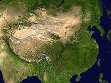
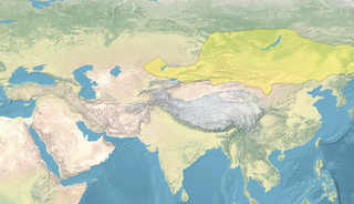
Eastern Asia. Color is proportional to rainfall. Note the oval Tarim Basin at the west end of the Kansu Corridor.
This article summarizes the History of the eastern steppe, the eastern third of the Eurasian Steppe, that is, the grasslands of Mongolia and northern China. It is a companion to History of the central steppe and History of the western steppe. Most of its recorded history deals with conflicts between the Han Chinese and the steppe nomads. Most of the sources are Chinese.
The area is bounded on the north by the forests of Siberia, on the east by mountains along the Pacific coast, on the southeast by a small area of agricultural China, on the south by the Tibetan plateau and on the west by the mountains along the former Sino-Soviet border. Between these mountains and Siberia the so-called Dzungarian Gate opens out onto the vast Kazakh steppe to the west.
The area has three parts: Manchuria, Mongolia and Dzungaria. The core of the area is Mongolia, not only the Outer Mongolia that is seen on maps but also Inner Mongolia and much of Gansu which are now part of China. The Gobi Desert or semi-desert separates Outer and Inner Mongolia. The best grazing lands are in the north around such places as the Orkhon River and Onon Rivers. To the east the steppe extends into "Manchuria" but does not reach the coast because of mountains and moisture from the Pacific. The Manchurian steppe merges northward to a deciduous forest-steppe and then the coniferous forest of Siberia. To the south it merges into agricultural China. In the west Dzungaria or northern Xinjiang is a westward extension of Mongolia. To the west of that the Dzungarian Gate leads to the extensive steppes of Kazakhstan, particularly the region of Jetysu.
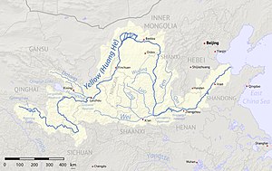
In the southeast is the agricultural area of the North China Plain, roughly around Beijing and southward. West of that are the mountains of Shanxi (the name means "western mountains"). West of the mountains is the Ordos Loop of the Yellow River. On the southern side of the Ordos country is the Wei River valley which was long a center of Chinese civilization. The northern Ordos region is semi-desert and part of Inner Mongolia. The area was often disputed between agricultural China and the steppe nomads. West of that is the long and narrow Gansu Corridor. It is bounded on the south by the high and desolate Tibetan plateau and on the north by the grasslands of Mongolia. Along it is a chain of oases which form a natural caravan route from China westward. At the west end of the Gansu corridor is the oval Tarim Basin with its central desert and ring of oases around the edges. The Tarim is desert rather than steppe but interacted with the steppe in various ways. At the west end of the Tarim Basin passes lead over the mountains south to India and west to central Asia, Persia and Europe. The Gansu-Tarim route was the main axis of the Silk Road that connected China with the rest of the world. When Chinese dynasties were strong they would often extend a finger of power along the Gansu corridor into the Tarim Basin. When the nomads were strong they would try to control, tax or loot the Gansu-Tarim region.
On the northern edge can be noted the forest-steppe of north Manchuria and west of that the thinly-populated mountains of Transbaikalia. Around Lake Baikal the forest and steppe peoples have tended to blend, producing the modern Buryats. West of that is the Altai-Sayan region noted for its metalwork, especially the Minusinsk Basin.
Historical outline
A note on ethnonyms: Most of steppe history consists of statements like "in a certain year people A replaced people B." These "peoples" are usually some dynasty, clan or tribe that gained control over its neighbors and became militarily or politically significant. Borders were ill-defined and fluctuated, as did the ruler's power. Daily life went on without much regard to whoever was in power. "Replacement" usually means a mere change of ruling group, but sometimes involved a genuine folk migration or change in language or religion. Since historical records depend on scattered reports from neighboring literate societies, there is substantial uncertainty especially in the early period.
In 221 BC, China proper was unified by the Qin dynasty and after a brief civil war, more permanently by the Han dynasty (206 BC – 220 AD). About 209 BC the steppe tribes were united by the Xiongnu. The two unifications were connected in that the nomads had to unite to protect themselves from the powerful Han dynasty and the Xiongnu ruler could strengthen himself with Han tribute. In the east, the Xiongnu conquered the Donghu in Manchuria and in the west they drove the Wusun and Yuezhi westward. The Wusun soon disappeared, but the Yuezhi later had a great career as the Kushans of Afghanistan. After about 75 years of internal consolidation and external tribute, the Emperor Wu of Han adopted a forward policy. Zhang Qian went west (138-125 BC) and returned with the first good reports of the Western Regions. During the Han-Xiongnu Wars the southern Xiongnu in Inner Mongolia were subjugated and the northern Xiongnu were driven to northern Mongolia where they were broken up around 89 AD. The Han gained control of the Gansu Corridor and the Tarim Basin with some influence westward. This opened the Silk Road and led to the appearance of Chinese silk in the Roman Empire. As the Han dynasty declined, the Tarim Basin experienced complex shifts of power between the Han, Xiongnu remnants and local rulers.
Xianbei, Rouran and Turk (220–840)
220–589: China disunited: From the fall of the Eastern Han until the reunification of China proper under the Sui dynasty, northern China was usually ruled by short-lived dynasties of steppe origin, known in historiography as the Sixteen Kingdoms and Northern and Southern dynasties periods. During this period, Buddhism spread from northern India north to the Tarim Basin and east along the Gansu corridor to China.
93–234: Xianbei: The Mongolic Xianbei (former Donghu) spread from Manchuria and ruled the steppes as the Xianbei state. They were defeated by the short-lived Cao Wei dynasty which had some control over Gansu.
402–552: Rouran: A branch of the Xianbei reunited the Mongolian Plateau as the Rouran Khaganate. The Rouran were the first to use the title Khagan or Khan.
589–907: Sui and Tang dynasties: China proper was reunited by the short-lived Sui dynasty followed by the longer-lived Tang dynasty (618–907) which regained the Tarim Basin, entered the Pamirs and fought the expanding Muslims at the Battle of Talas in 751.
552–744:Turkic Khaganate: The Gokturks lived in the Altai region, engaged in metalwork and were subjects of the Rouran. They were the first ruling group who were clearly Turkic (Orkhon Inscriptions). In 552, they overthrew the Rouran and established the First Turkic Khaganate which extended far to the west. After about 25 years, the western half broke off, which marks the beginning of the Eastern Turkic Khaganate. This lasted from 581 to 630, was conquered by the Tang dynasty (630–682), and was later restored (682–744).
744–840 Uighurs: These Turkic people lived around Lake Baikal and were probably descended from the Tiele and earlier Dingling. They founded the Uyghur Khaganate and were much influenced by Sogdian merchants from central Asia. In the twentieth century their name was given to the Turkic inhabitants of the Tarim Basin.
840-?: Kirghiz: The Yenisei Kirghiz came from the southern Yenisey and closely related to Turkic Khakas and Fuyu Kyrgyz people. They overthrew the Uighurs with help from the Tang dynasty, but never formed a great empire.
Mongols and Manchus (907–1912)
916–1125 Khitans and Liao dynasty: The Mongolic Khitans founded the Liao dynasty in 916. After the collapse of the Liao in 1125, remnants fled west and formed the Western Liao dynasty.
1125–1234: Jurchens and Jin dynasty: The Jurchens were a Tungusic forest people in northern Manchuria. They established the Jin dynasty in 1115 and overthrew the Liao dynasty in 1125. Southern China remained under the Song dynasty.
982–1227: Tanguts and Western Xia dynasty: The Tibetan Tanguts controlled the Gansu corridor and established the Western Xia dynasty.
1206–1368 Mongols and Yuan dynasty: In 1206, the Mongol tribes were united by Genghis Khan who captured north China and most of central Asia. His sons and grandsons took Manchuria, south China, Persia and Russia forming the Mongol Empire. It split into four parts, with the Yuan dynasty ruling over the eastern steppe. Western Xinjiang was ruled from central Asia by the Chagatai Khanate.
1368–1644 Ming dynasty: The Ming dynasty defeated the Yuan dynasty, forcing the latter to retreat north, thus forming the Northern Yuan dynasty.
1636–1912 Manchus and Qing dynasty: A group of Jurchens took the name Manchu established the Qing dynasty. Its westward expansion is noted under Dzungars below.
1582–present: Russia: From 1582 Russian adventurers made themselves masters of the Siberian forests. The Chinese border with Russia at Manchuria and Outer Mongolia was defined in 1689 and 1727 respectively.
1620–1759 Dzungars: Around 1620 the western Mongols established the Dzungar Khanate in Dzungaria which was the last of the steppe empires. In 1696 they were driven out of Outer Mongolia which fell to the Qing dynasty. In 1720 they were driven out of Tibet which became part of the Qing dynasty. In 1759 Dzungaria was conquered by the Chinese who then moved south to the Tarim Basin, thereby completing the current western border of China. Dzungaria and the Tarim Basin were combined for the first time as the province of Xinjiang.
Recent period
In the 19th century Western imperialism and industrialism began to impact eastern Asia. Steppe nomadism and many traditional Chinese institutions gradually became obsolete, both economically and militarily. In 1860 Russia annexed north and east Manchuria which soon acquired a Russian population. There was a massive migration of Han Chinese into Manchuria and Inner Mongolia which socially removed these areas from the steppe and attached them to China. When the Manchu dynasty fell in 1912 the Mongols claimed that they had been subject to the Manchus rather than China and were therefore now independent. This Russian-backed independence may have prevented Chinese immigration into the area. In recent decades there has been a significant Han migration into Xinjiang.
Denis Sinor (editor), The Cambridge History of Early Inner Asia, 1990
Cristoph Baumer, The History of Central Asia, 2012--, 3 volumes
Sources in the linked articles. There appears to be no book devoted specifically to the whole history of the eastern steppe.
Related Research Articles
The Göktürks, Türks, Celestial Turks or Blue Turks were a nomadic confederation of Turkic peoples in medieval Inner Asia. The Göktürks, under the leadership of Bumin Qaghan and his sons, succeeded the Rouran Khaganate as the main power in the region and established the First Turkic Khaganate, one of several nomadic dynasties that would shape the future geolocation, culture, and dominant beliefs of Turkic peoples.
The Xianbei were an ancient nomadic people that once resided in the eastern Eurasian steppes in what is today Mongolia, Inner Mongolia, and Northeastern China. The Xianbei were strongly suggested to be a multi-ethnic confederation with Mongolic, Tungusic and Turkic peoples. They originated from the Donghu people who splintered into the Wuhuan and Xianbei when they were defeated by the Xiongnu at the end of the third century BC. The Xianbei were largely subordinate to larger nomadic powers and the Han dynasty until they gained prominence in 87 AD by killing the Xiongnu chanyu Youliu. However unlike the Xiongnu, the Xianbei political structure lacked the organization to pose a concerted challenge to the Chinese for most of their time as a nomadic people.
The Rouran Khaganate, also Juan-Juan Khaganate, was a tribal confederation and later state founded by a people of Proto-Mongolic Donghu origin. The Rouran supreme rulers used the title of "khagan", a popular title borrowed from the Xianbei. The Rouran Khaganate lasted from the late 4th century until the middle 6th century, when they were defeated by a Göktürk rebellion at the peak of their power, which subsequently led to the rise of the Turks in world history.
The proto-Mongols emerged from an area that had been inhabited by humans and predecessor hominin species as far back as 45,000 years ago during the Upper Paleolithic. The people there went through the Bronze and Iron Ages, forming tribal alliances, peopling, and coming into conflict with early polities in the Central Plain.
Khagan or Qaghan is a title of imperial rank in Turkic, Mongolic, and some other languages, equal to the status of emperor and someone who rules a khaganate (empire). The female equivalent is Khatun.
The Tarim Basin is an endorheic basin in Xinjiang, Northwestern China occupying an area of about 888,000 km2 (343,000 sq mi) and one of the largest basins in Northwest China. Located in China's Xinjiang region, it is sometimes used synonymously to refer to the southern half of the province, that is, Southern Xinjiang or Nanjiang, as opposed to the northern half of the province known as Dzungaria or Beijiang. Its northern boundary is the Tian Shan mountain range and its southern boundary is the Kunlun Mountains on the edge of the Tibetan Plateau. The Taklamakan Desert dominates much of the basin. The historical Uyghur name for the Tarim Basin is Altishahr, which means 'six cities' in Uyghur. The region was also called Little Bukhara or Little Bukharia.
Xinjiang is historically consisted of two main geographically, historically, and ethnically distinct regions with different historical names: Dzungaria north of the Tianshan Mountains; and the Tarim Basin south of the Tianshan Mountains, currently mainly inhabited by the Uyghurs. They were conquered by the Qing dynasty in the 18th century, and after the Dungan Revolt (1862–1877) the Qing reconquered both regions and integrated them into one province named Xinjiang in 1884.
The Eurasian Steppe, also called the Great Steppe or The Steppes, is the vast steppe ecoregion of Eurasia in the temperate grasslands, savannas and shrublands biome. It stretches through Hungary, Bulgaria, Romania, Moldova, Ukraine, southern Russia, Kazakhstan, Xinjiang, Mongolia and Manchuria, with one major exclave, the Pannonian steppe, located mostly in Hungary.
Yueban, colloquially: "Weak Xiongnu", was the name used by Chinese historians for remnants of the Northern Xiongnu in Zhetysu, now part of modern-day Kazakhstan. In Chinese literature they are commonly called Yueban. The Yuebans gained their own visibility after disintegration of the Northern Xiongnu state, because unlike the main body of the Northern Xiongnu, who escaped from the Chinese sphere of knowledge, the Yueban tribes remained closer to China.
Nomadic empires, sometimes also called steppe empires, Central or Inner Asian empires, were the empires erected by the bow-wielding, horse-riding, nomadic people in the Eurasian Steppe, from classical antiquity (Scythia) to the early modern era (Dzungars). They are the most prominent example of non-sedentary polities.
The Khitan people were a historical nomadic people from Northeast Asia who, from the 4th century, inhabited an area corresponding to parts of modern Mongolia, Northeast China and the Russian Far East.
The Xianbei state or Xianbei confederation was a nomadic empire which existed in modern-day Mongolia, Inner Mongolia, northern Xinjiang, Northeast China, Gansu, Buryatia, Zabaykalsky Krai, Irkutsk Oblast, Tuva, Altai Republic and eastern Kazakhstan from c. 93 to 234. Like most ancient peoples known through Chinese historiography, the ethnic makeup of the Xianbei is unclear, though they are believed to have been a Proto-Mongolic people. There are also other strong suggestions that they were a multi-ethnic confederation with Mongolic and Turkic influences. They originated from the Donghu people who splintered into the Wuhuan and Xianbei when they were defeated by the Xiongnu at the end of the third century BC. The Xianbei were largely subordinate to larger nomadic powers and the Han dynasty until they gained prominence in 87 AD by killing the Xiongnu chanyu Youliu. However unlike the Xiongnu, the Xianbei political structure lacked the organization to pose a concerted challenge to the Chinese for most of their time as a nomadic people.
Various nomadic empires, including the Xiongnu, the Xianbei state, the Rouran Khaganate (330–555), the First (552–603) and Second Turkic Khaganates (682–744) and others, ruled the area of present-day Mongolia. The Khitan people, who used a para-Mongolic language, founded an empire known as the Liao dynasty (916–1125), and ruled Mongolia and portions of North China, northern Korea, and the present-day Russian Far East.
The Sixteen Kingdoms, less commonly the Sixteen States, was a chaotic period in Chinese history from AD 304 to 439 when northern China fragmented into a series of short-lived dynastic states. The majority of these states were founded by the "Five Barbarians", non-Han peoples who had settled in northern and western China during the preceding centuries, and had launched a series of rebellions against the Western Jin dynasty in the early 4th century. However, several of the states were founded by the Han people, and all of the states—whether ruled by Xiongnu, Xianbei, Di, Jie, Qiang, Han, or others—took on Han-style dynastic names. The states frequently fought against both one another and the Eastern Jin dynasty, which succeeded the Western Jin in 317 and ruled southern China. The period ended with the unification of northern China in 439 by the Northern Wei, a dynasty established by the Xianbei Tuoba clan. This occurred 19 years after the Eastern Jin collapsed in 420, and was replaced by the Liu Song dynasty. Following the unification of the north by Northern Wei, the Northern and Southern dynasties era of Chinese history began.
The Ordos Plateau, also known as the Ordos Basin or simply the Ordos, is a highland sedimentary basin in parts of most Northern China with an elevation of 1,000–1,600 m (3,300–5,200 ft), and consisting mostly of land enclosed by the Ordos Loop, a large northerly rectangular bend of the Yellow River. It is China's second largest sedimentary basin with a total area of 370,000 km2 (140,000 sq mi), and includes territories from five provinces, namely Shaanxi, Gansu, Ningxia, Inner Mongolia and a thin fringe of Shanxi, but is demographically dominated by the former three, hence is also called the Shaan-Gan-Ning Basin. The basin is bounded in the east by the Lüliang Mountains, north by the Yin Mountains, west by the Helan Mountains, and south by the Huanglong Mountains, Meridian Ridge and Liupan Mountains.
The conquest of the Western Turks, known as the Western Tujue in Chinese sources, was a military campaign in 655–657 led by the Tang dynasty generals Su Dingfang and Cheng Zhijie against the Western Turkic Khaganate ruled by Ashina Helu. The Tang campaigns against the Western Turks began in 640 with the annexation of the Tarim Basin oasis state Gaochang, an ally of the Western Turks. Several of the oasis states had once been vassals of the Tang dynasty, but switched their allegiance to the Western Turks when they grew suspicious of the military ambitions of the Tang. Tang expansion into Central Asia continued with the conquest of Karasahr in 644 and Kucha in 648. Cheng Zhijie commanded the first foray against the West Tujue, and in 657 Su Dingfang commanded the main army dispatched against the Western Turks, while the Turkic generals Ashina Mishe and Ashina Buzhen led the side divisions. The Tang troops were reinforced by cavalry supplied by the Uyghurs, a tribe that had been allied with the Tang since their support for the Uyghur revolt against the Xueyantuo. Su Dingfang's army defeated Helu at the battle of Irtysh River.
The Tuoba (Chinese) or Tabgatch, also known by other names, was an influential Xianbei clan in early imperial China. During the Sixteen Kingdoms after the fall of Han and the Three Kingdoms, the Tuoba established and ruled the state of Dai in northern China. The dynasty ruled from 310 to 376 and then restored it in 386. The same year, they renamed the state Wei, later distinguished in Chinese historiography as the Northern Wei. This powerful state gained control of most of northern China, supporting Buddhism while increasingly sinicizing. As part of this process, in 496, the Xiaowen Emperor changed the dynasty's personal name from Tuoba to Yuan. The kingdom split into Eastern and Western Wei in 535, with the Western Wei's rulers briefly resuming use of the Tuoba name in 554.
The Qing dynasty in Inner Asia was the expansion of the Qing dynasty's realm in Inner Asia in the 17th and the 18th century AD, including both Inner Mongolia and Outer Mongolia, both Manchuria and Outer Manchuria, Tibet, Qinghai and Xinjiang.
This is a short History of the central steppe, an area roughly equivalent to modern Kazakhstan. Because the history is complex it is mainly an outline and index to the more detailed articles given in the links. It is a companion to History of the western steppe and History of the eastern steppe and is parallel to the History of Kazakhstan and the History of central Asia.
This page is based on this Wikipedia article Text is available under the CC BY-SA 4.0 license; additional terms may apply. Images, videos and audio are available under their respective licenses.