Bristol is an independent city in the Commonwealth of Virginia. As of the 2010 census, the population was 17,835. It is the twin city of Bristol, Tennessee, just across the state line, which runs down the middle of its main street, State Street. The Bureau of Economic Analysis combines the city of Bristol, Virginia, with neighboring Washington County, Virginia, for statistical purposes. Bristol is a principal city of the Kingsport–Bristol–Bristol, TN-VA Metropolitan Statistical Area, which is a component of the Johnson City–Kingsport–Bristol, TN-VA Combined Statistical Area – commonly known as the "Tri-Cities" region.

Sullivan County is a county located in the U.S. state of Tennessee. As of the 2010 census, the population was 156,823. Its county seat is Blountville.
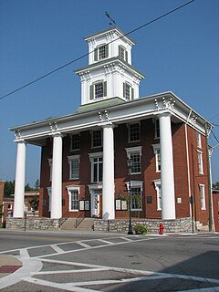
Blountville is a census-designated place (CDP) in and the county seat of Sullivan County, Tennessee, United States. The population was 3,074 at the 2010 census. It is the only Tennessee county seat not to be an incorporated city or town.

Gate City is a town in Scott County, Virginia, United States. The population was 2,034 at the 2010 census. It is the county seat of Scott County.

The Holston River is a 136-mile (219 km) river that flows from Kingsport, Tennessee, to Knoxville, Tennessee. Along with its three major forks, it comprises a major river system that drains much of northeastern Tennessee, southwestern Virginia, and northwestern North Carolina. The Holston's confluence with the French Broad River at Knoxville marks the beginning of the Tennessee River.

Mendota is an unincorporated community in Washington County in the southwestern part of the U.S. state of Virginia, at an elevation of approximately 1800 feet. It is part of the Kingsport–Bristol (TN)–Bristol (VA) Metropolitan Statistical Area, which is a component of the Johnson City–Kingsport–Bristol, TN-VA Combined Statistical Area – commonly known as the "Tri-Cities" region.

Bays Mountain is a ridge of the Ridge-and-Valley Appalachians, located in eastern Tennessee. It runs southwest to northeast, from just south of Knoxville to Kingsport.

Holston Mountain is a mountain ridge in Upper East Tennessee and southwest Virginia, in the United States. It is in the Blue Ridge Mountains part of the Appalachian Mountains. Holston Mountain is a very prominent ridge-type mountain in Tennessee's Ridge and Valley Region, about 28 miles (45 km) long, running from southwest to northeast, covering about 268 square miles (694 km²). Its highest summit is Holston High Point, on which a Federal Aviation Administration (FAA) aircraft navigational beacon is located, at an elevation of 4,280 feet above mean sea level. The second highest point is Rye Patch Knob, at 4,260 feet above mean sea level. The third highest point is Holston High Knob where an old dismantled Cherokee National Forest fire tower marks the elevation at 4,136 feet above mean sea level.
Naulakla is an unincorporated community in Caroline County, in the U.S. state of Virginia.
Morrison City is an unincorporated community in Sullivan County, Tennessee, United States. Named for pioneer settler Peter Morison, Morrison City developed with the industrial growth of nearby Kingsport, Tennessee in the 1930s. Peter Morison, his wife Mary Kirkpatrick Morison, and other relatives, are buried in the Morrison Chapel Cemetery, in the heart of the community. They were awarded a land grant by the state of North Carolina, which controlled the area prior to Tennessee Statehood, in 1780. This was to recognize distinguished service during the Battle of King's Mountain.
Goose Pimple Junction is an unincorporated community in Washington County, Virginia, in the United States.
Calvin is an unincorporated community in Lee County, Virginia, in the United States.
Darnell Town is an unincorporated community in Lee County, Virginia, in the United States.
Seminary is an unincorporated community in Lee County, Virginia, in the United States. It had previously been known as Turkey Cove, and during the American Civil War the 64th Virginia Infantry trained on the church grounds, partly because its chaplain was Reuben Steele.
Shepherd Hill is an unincorporated community in Lee County, Virginia, in the United States.
Holston High School is a public secondary school located in Washington County, Virginia.
Holston Valley is an unincorporated community in eastern Sullivan County, Tennessee, United States. Holston Valley is located along U.S. Route 421 and State Route 44 southeast of Bristol.
Dumontville is an unincorporated community in Fairfield County, in the U.S. state of Ohio.
Plum Valley is an extinct town in west central Texas County, in the U.S. state of Missouri. The GNIS classifies it as a populated place. The community lies near the East Fork of Roubidoux Creek about one mile west of Missouri Route 17 and 3.5 miles west of Bucyrus.