Indian Home Guard Camp (Baxter Springs)

Last updated

In June 1862 two Union camps were established in the vicinity of what is today Baxter Springs, Kansas. One was Camp Hunter, located in what is now the center of the town. The other was the Indian Home Guard Camp, located at Little Five Mile Creek, 1½ miles southeast of Camp Hunter.

Baxter Springs, Kansas City in Kansas, United States

Baxter Springs is a city in Cherokee County, Kansas, United States, and located along Spring River. As of the 2010 census, the city population was 4,238; it is the most populous city of Cherokee County.

Camp Hunter was established in June 1862 or a bit earlier at what is now Baxter Springs, Kansas. It was established by Union troops. At the same time Indian Home Guard regiments established a camp nearby on Little Five Mile Creek.

The area where the Indian camp was located was flat ground. Little is known about the camp. Hugh Thompson, who was stationed as a scout in the area, said 6,000 men were stationed between the Indian camp and Camp Hunter in June 1862. The 2nd Regiment of the Indian Home Guard was organized there and placed under the command of Col. John Ritchie. This regiment was organized from June 22 to July 18. It took so long to organize because of various political disagreements amongst the government negotiators.

John Ritchie was an American abolitionist in Kansas who served in the Union Army during the American Civil War

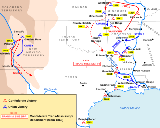
The camps at Baxter Springs were established with three goals in mind. One was to escort wagon trains heading south into Indian Territory, as much of that entity was held by Indians owing loyalty to the Confederacy. Therefore, wagon trains traveling through the Indian Territory were in danger of being attacked. [1]

Indian Territory U.S. 17th-, 18th- and early-20th-century territory set aside by the United States Government for the relocation of the indigenous peoples of the Americas

As general terms, Indian Territory, the Indian Territories, or Indian country describe an evolving land area set aside by the United States Government for the relocation of Native Americans who held aboriginal title to their land. In general, the tribes ceded land they occupied in exchange for land grants in 1803. The concept of an Indian Territory was an outcome of the 18th- and 19th-century policy of Indian removal. After the Civil War (1861–1865), the policy of the government was one of assimilation.

A second goal was to provide a good place to rest tired cavalry horses. There was much tall native prairie grass just west of the camps. The troops in the camps were needed to guard the resting horses.

A third goal was to have troops in the area to contest the activities of Bushwhackers and Confederate Indians who operated in the area. [2]

As soon as both camps were established, acction was taken to uproot a guerrilla camp commanded by Capt. Thomas Livingston. The camp was overrun, but Livingston and his men escaped. Further attempts to capture or destroy the guerrilla force ended in failure. When attacked, the guerrillas would disappear. It was discovered after the Civil War they had a hidden camp on the border with Missouri. (See Livingston's Hideout.) [3]

Livingston's Hideout was most likely the only permanent Confederate military camp inside Kansas during the Civil War. It was in the very corner of southeast Kansas, in the very corner of Cherokee County, Kansas. It was about 2 miles (3.2 km) north of the border with Indian Territory and it was less than 100 feet (30 m) west of the border with Missouri. It was 5 miles (8.0 km) west of Baxter Springs, where a series of Union military posts existed from 1862 to 1863. Thomas R. Livingston became a leader of a group of Confederate guerrillas in the area, becoming first a captain and then a major. He needed locations to hide himself and his guerrillas from pursuing Union troops and this hideout suited the guerrillas well. The guerrillas sought to spy on Union forces and raiding units he found small enough to defeat.

The white soldiers were at first skeptical of the abilities of the Home Guards. They wore mismatched uniforms and wore stovepipe hats, looking little like soldiers. Their ponies were so small the riders' feet almost touched the ground when they rode. Someone said it appeared the Indians were walking as they were riding. However, the Indians proved themselves well in battle. Their ponies proved useful, as they were well adapted to the summer heat and did not wear out, as did many of the larger horses of the white troops. [4]

In early September Camp Hunter and the Indian Home Guard camp found themselves on the front line. The soldiers were warned of an approaching Confederate regiment. Both camps were quickly abandoned. Camp Hunter was briefly occupied by the Confederate force. After the Confederate force and possibly other Confederates shortly later passed through, neither camp was used again. [5]

Related Research Articles

Border states (American Civil War) slave states that had not declared a secession from the Union during the American Civil War

In the context of the American Civil War (1861–65), the border states were slave states that did not declare a secession from the Union and did not join the Confederacy. To their north they bordered free states of the Union and to their south they bordered Confederate slave states. Of the 34 U.S. states in 1861, nineteen were free states and fifteen were slave states. Two slave states never declared a secession or adopted an ordinance: Delaware and Maryland. Four others did not declare secession until after the Battle of Fort Sumter and were briefly considered to be border states: Arkansas, North Carolina, Tennessee and Virginia—after this, they were less frequently called "border states". Also included as a border state during the war is West Virginia, which was formed from 50 counties of Virginia and became a new state in the Union in 1863.

Battle of Baxter Springs Battle and massacre of the American Civil War

The Battle of Baxter Springs, more commonly known as the Baxter Springs Massacre, was a minor battle of the American Civil War fought on October 6, 1863, near the present-day town of Baxter Springs, Kansas.

Battle of Lone Jack

The Battle of Lone Jack was a battle of the American Civil War, occurring on August 15–16, 1862 in Jackson County, Missouri. The battle was part of the Confederate guerrilla and recruiting campaign in Missouri in 1862.

The Indian Home Guard were volunteer infantry regiments recruited from the Five Civilized Tribes of Indian Territory to support the Union during the American Civil War. The list of Confederate units of Indian Territory is shown separately.

Trans-Mississippi Theater of the American Civil War

The Trans-Mississippi Theater of the American Civil War consists of the major military operations west of the Mississippi River. The area is often thought of as excluding the states and territories bordering the Pacific Ocean, which formed the Pacific Coast Theater of the American Civil War (1861-1865).

The 12th Regiment Iowa Volunteer Infantry was an infantry regiment that served in the Union Army during the American Civil War.

Skirmish at Island Mound American Civil War skirmish

The Skirmish at Island Mound was a skirmish of the American Civil War, occurring on October 29, 1862, in Bates County, Missouri. The Union victory is notable as the first known event in which an African-American regiment engaged in combat against Confederate forces during the war.

Indian Territory in the American Civil War

During the American Civil War, most of what is now the U.S. state of Oklahoma was designated as the Indian Territory. It served as an unorganized region that had been set aside specifically for Native American tribes and was occupied mostly by tribes which had been removed from their ancestral lands in the Southeastern United States following the Indian Removal Act of 1830. As part of the Trans-Mississippi Theater, the Indian Territory was the scene of numerous skirmishes and seven officially recognized battles involving both Native American units allied with the Confederate States of America and Native Americans loyal to the United States government, as well as other Union and Confederate troops.

Fort Baxter, also known as Fort Blair, was a small US Army post located in the southeast corner of Kansas near present-day Baxter Springs. This area was known as the Cherokee Strip. It was one of a few Kansas forts attacked by Confederate forces during the American Civil War. At one point the Confederate government claimed authority over the Neutral Lands. Both Union and Confederate troops operated in the area, as did guerrilla forces and militias prevalent in the Kansas-Missouri border area.

Kansas has always been home to many forts and military posts.

On March 7, 1862, Confederate guerrillas under William C. Quantrill raided the small Kansas town of Aubry, southwest of Kansas City, Missouri, and just west of the Kansas-Missouri border. Three residents were killed in the raid and much property was carted away by the guerrillas.

In early May 1863 a temporary camp, Camp Hooker, was established at the site of what later became Baxter Springs, Kansas. This area was located in what was known as the Cherokee Strip (Kansas). In late May while the camp commander, Col. James M. Williams, was in Fort Scott, the troops moved the camp three blocks to the east to what is now Washington School Hill. The new camp, Camp Ben Butler (named after Maj. Gen. Benjamin Butler, was in a highly defendable position. It occupied a plateau that covered more than two square blocks. Only a small area to the south allowed easy access to camp. In fact, much of the surrounding area was practically impenetrable by men or horses.

Camp Drywood was established by the US Army in fall 1862. It was located about fifteen miles south of Fort Scott, Kansas. It was intended to serve as a military post guarding against Confederate guerrillas in the area. However, it ended up being the temporary home to 2,000 Cherokee and Creek Indians from Indian Territory who were loyal to the Union.

Camp Defiance was a military encampment in eastern Kansas, U.S., during 1861–1862. In December 1861, the town of Potosi, Kansas, along the Kansas-Missouri border, was attacked by Confederate guerrillas. Very soon Col. James Montgomery stationed the Kansas 3rd Regiment about 4 miles (6 km) to the northeast.

Mount Oread Civil War posts

Lawrence, Kansas was not well defended in the early part of the Civil War. That ended with William Quantrill's devastating guerrilla raid August 21, 1863. By early 1864 Union soldiers were permanently camped on the top and slopes of Mount Oread, then to Lawrence's southwest. It seems the camp was originally named Camp Ewing, after Brig. Gen. Thomas Ewing.

Fort McKean is a fort located inside Kansas along the Kansas-Missouri border. On November 14, 1862, Company C of the 3rd Wisconsin Cavalry, led by Lieut. James B. Pond, established a camp at Morris Mills on Drywood Creek. It was fifteen miles southeast of Fort Scott. Sometime later this camp was given the name of Fort McKean. The post was probably on the Fort Scott-Fort Gibson Military Road, and many, including Pond, thought the post was inside Missouri. Throughout its history, Fort McKean was a small post, ranging in strength from 20 to 60 men. It is unknown what buildings or defenses were erected there.

LeRoy's post was established September 12, 1861, by U.S. Senator James H. Lane, when Fort Scott was threatened by advancing Confederate troops. LeRoy is a town in eastern Kansas. The post was one of many Union posts established in eastern Kansas to guard against Confederate guerrilla attack. In spring 1862 a number of Indian refugees who had first camped at Fort Row were moved further north to Fort Belmont and the post at LeRoy.

Osage Mission's post was located at the Osage Catholic Mission, which was established in 1847. Eventually, Osage Mission became the town of St. Paul, Kansas, inside what would become Neosho County, Kansas. The Mission was located about 35 miles (56 km) north of the Kansas-Indian Territory border. Indian Territory eventually became the state of Oklahoma. When the Civil War erupted, Father John Schoenmakers wanted to keep the Mission as neutral ground and thus out of the conflict. Although at one point Schoenmakers had to flee for a time, he pretty much succeeded in keeping Osage Mission itself out of harm's way.

References

  1. Woodbury F. Pride, The History of Fort Riley (N.p.: 1926), p. 46; William E. Connelley, Quantrill and the Border Wars (New York: Pageant Book Co., 1956), 1956 ed., p. 422; Betty F. Kyrias, "The Civil War in Baxter Springs, Kansas, 1862–1863" (Baxter Springs, Kansas.: Baxter Springs, Kansas, Historical Society, August 8, 1988), pp. 1–2; Kyrias, letter to William C. Pollard, Jr., April 1, 1993, p. 3; Kyrias, interview with Pollard, Baxter Springs, Kans., May 27, 1993; Pollard, memorandum to Daniel C. Fitzgerald, June 1, 1993, pp.1–2; Pollard, "Forts and Military Posts in Kansas: 1854–1865" (Ph.D. dissertation, Faith Baptist College and Seminary, 1997), pp. 21–3.
  2. Kyrias, "The Civil War in Baxter Springs," pp. 1–2.
  3. Kyrias, "The Civil War in Baxter Springs," pp. 1–3; Kyrias, letter, p. 3.
  4. Kyrias, "The Civil War in Baxter Springs," pp. 1–2.
  5. Kyrias, "The Civil War in Baxter Springs," pp. 2–3; Col. Stand Watie, report, The War of the Rebellion (Washington: Government Printing Office, 1885), Series I, Vol. XIII, p. 94; Col. John Ritchie, report, The War of the Rebellion (1885), Series I, Vol. XIII, p. 661; F. R. Lubbock, report, The War of the Rebellion (1902), Series I, Vol. LIII, p. 784; Col. Tresevant C. Hawpe, report, The War of the Rebellion (1885), Series I, Vol. XIII, pp. 305–6; Patricia L. Faust, "Newtonia, Mo., first eng. at," in Faust, ed., Historical Times Illustrated Encyclopedia of the Civil War (New York: Harper & Row, 1986), pp. 530–1; Kyrias, letter, pp. 1–3; Col. William Weer, report, The War of the Rebellion (1885), Series I, Vol. XIII, p. 672.