Inmarsat-C

Last updated
Inmarsat-C terminal (centre) Station radio haut.JPG
Inmarsat-C terminal (centre)

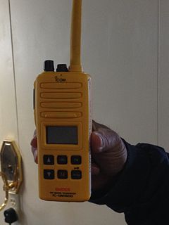
Inmarsat-C is a two-way, packet data service operated by the telecommunications company Inmarsat which operates between mobile earth stations (MES) and land earth stations (LES). It became fully operational after a period of pre-operational trials in January 1991. The advantages of Inmarsat-C compared to Inmarsat-A are low cost, smaller and uses a smaller omni-directional antenna. The disadvantage is that voice communication is not possible with Inmarsat-C. [1] The service is approved for use under the Global Maritime Distress and Safety System (GMDSS), meets the requirements for Ship Security Alert Systems (SSAS) defined by the International Maritime Organization (IMO) and is the most widely used service in fishing Vessel Monitoring Systems (VMS).

Inmarsat company

Inmarsat plc is a British satellite telecommunications company, offering global mobile services. It provides telephone and data services to users worldwide, via portable or mobile terminals which communicate with ground stations through thirteen geostationary telecommunications satellites. Inmarsat's network provides communications services to a range of governments, aid agencies, media outlets and businesses with a need to communicate in remote regions or where there is no reliable terrestrial network. The company is listed on the London Stock Exchange, is a constituent of the FTSE 250 Index, and is a financial and technical sponsor of Télécoms Sans Frontières.

The Ship Security Alert System (SSAS) is part of the ISPS code and is a system that contributes to the International Maritime Organization's (IMO)'s efforts to strengthen maritime security and suppress acts of terrorism and piracy against shipping. The system is an IMO regulated system. In case of attempted piracy or terrorism, the ship's SSAS beacon can be activated, and appropriate law-enforcement or military forces can be dispatched. An SSAS beacon operates with similar principles to the aircraft transponder emergency code 7700.

International Maritime Organization Specialised agency of the United Nations

The International Maritime Organization (IMO), known as the Inter-Governmental Maritime Consultative Organization (IMCO) until 1982, is a specialised agency of the United Nations responsible for regulating shipping. The IMO was established following agreement at a UN conference held in Geneva in 1948 and the IMO came into existence ten years later, meeting for the first time in 1959. Headquartered in London, United Kingdom, the IMO currently has 174 member states and three associate members.

Contents

The service works with a store-and-forward method which enables interface with data network transfer including; e-mail; SMS; telex; remote monitoring; tracking (position reporting); chart and weather updates; maritime safety information (MSI); maritime security; GMDSS; and SafetyNET [2] and FleetNET services; two-way messaging; data reporting and polling; Safety/Emergency alerting.

SMS Text messaging service component

SMS is a text messaging service component of most telephone, internet, and mobile-device systems. It uses standardized communication protocols to enable mobile devices to exchange short text messages. An intermediary service can facilitate a text-to-voice conversion to be sent to landlines. SMS was the most widely used data application at the end of 2010, with an estimated 3.5 billion active users, or about 80% of all mobile subscribers.

Data reporting is the process of collecting and submitting data which gives rise to accurate analyses of the facts on the ground; inaccurate data reporting can lead to vastly uninformed decision-making based on erroneous evidence. When data is not reported, the problem is known as underreporting; the opposite problem leads to false positives.

The service is operated via an Inmarsat-C Transceiver or a lower-power mini-C Transceiver. Data transfers between MES and LES at a rate of 600 bits/second. The frequencies for transmitting (TX) are 1626.5MHz -1645.5MHz and for receiving (RX) are 1530.0MHz - 1545.0MHz.

The service is available for maritime, land mobile and aeronautical use.

This system was also used to track the BBC's project "The Box". [3] BBC News followed a container around the world for a year to tell stories of globalization and the world economy.

BBC Box

The Box or BBC Box is a single ISO intermodal container that started to be tracked by BBC News in September 2008. The intention was to track the container for a period of one year, in a project to study international trade and globalisation. The Box was fitted with tracking equipment and painted in a special one-off livery.

Intermodal container Standardized reusable steel box used for transporting goods

An intermodal container is a large standardized shipping container, designed and built for intermodal freight transport, meaning these containers can be used across different modes of transport – from ship to rail to truck – without unloading and reloading their cargo. Intermodal containers are primarily used to store and transport materials and products efficiently and securely in the global containerized intermodal freight transport system, but smaller numbers are in regional use as well. These containers are known under a number of names, such as simply container, cargo or freight container, ISO container, shipping, sea or ocean container, sea van or (Conex) box, sea can or c can.

Maritime Rescue Coordination Centers

The headquarters for Inmarsat C is located in London. The four Ocean Regions that are covered by Inmarsat C are:

Within each ocean region, there are approximately four or five Maritime Rescue Coordination Centers (MRCC). In total, there are over twenty MRCC's in the world, and each MRCC station contributes to a certain MRCC area. The MRCC stations are located in:

A rescue co-ordination centre (RCC) is a primary search and rescue facility in a country that is staffed by supervisory personnel and equipped for co-ordinating and controlling search and rescue operations.

Related Research Articles

International Mobile Satellite Organization

The International Mobile Satellite Organization (IMSO) is the intergovernmental organization that oversees certain public satellite safety and security communication services provided via the Inmarsat satellites. Some of these services concern:

Emergency position-indicating radiobeacon station A distress radiobeacon, a tracking transmitter that is triggered during an accident

An emergency position-indicating radiobeacon station is a distress radiobeacon, a tracking transmitter that is triggered during an accident. These are detected by satellites. The system is monitored by an international consortium of rescue services, COSPAS-SARSAT. The basic purpose of this system is to help rescuers find survivors within the so-called "golden day" during which the majority of survivors can usually be saved.

A distress signal, also known as a distress call, is an internationally recognized means for obtaining help. Distress signals are communicated by transmitting radio signals, displaying a visually observable item or illumination, or making a sound audible from a distance.

Marine VHF radio Radios operating in the very high frequency maritime mobile band

Marine VHF radio refers to the radio frequency range between 156 and 174 MHz, inclusive. The "VHF" signifies the very high frequency of the range. In the official language of the International Telecommunication Union the band is called the VHF maritime mobile band. In some countries additional channels are used, such as the L and F channels for leisure and fishing vessels in the Nordic countries.

The Global Maritime Distress and Safety System (GMDSS) is an internationally agreed-upon set of safety procedures, types of equipment, and communication protocols used to increase safety and make it easier to rescue distressed ships, boats and aircraft.

Navtex

Navtex is an international automated medium frequency direct-printing service for delivery of navigational and meteorological warnings and forecasts, as well as urgent maritime safety information (MSI) to ships.

A Maritime Mobile Service Identity (MMSI) is a series of nine digits which are sent in digital form over a radio frequency channel in order to uniquely identify ship stations, ship earth stations, coast stations, coast earth stations, and group calls. These identities are formed in such a way that the identity or part thereof can be used by telephone and telex subscribers connected to the general telecommunications network to call ships automatically.

Automatic identification system

The automatic identification system (AIS) is an automatic tracking system that uses transponders on ships and is used by vessel traffic services (VTS). When satellites are used to detect AIS signatures, the term Satellite-AIS (S-AIS) is used. AIS information supplements marine radar, which continues to be the primary method of collision avoidance for water transport.

International Cospas-Sarsat Programme

The International Cospas-Sarsat Programme is a satellite-aided search and rescue initiative. It is organized as a treaty-based, nonprofit, intergovernmental, humanitarian cooperative of 45 nations and agencies. It is dedicated to detecting and locating radio beacons activated by persons, aircraft or vessels in distress, and forwarding this alert information to authorities that can take action for rescue.

The radio frequency 2182 kHz is one of the international calling and distress frequencies for maritime radiocommunication in a frequency band allocated to the mobile service on primary basis, exclusively for distress and calling operations.

Vessel monitoring system

Vessel Monitoring Systems (VMS) is a general term to describe systems that are used in commercial fishing to allow environmental and fisheries regulatory organizations to track and monitor the activities of fishing vessels. They are a key part of monitoring control and surveillance (MCS) programs at national and international levels. VMS may be used to monitor vessels in the territorial waters of a country or a subdivision of a country, or in the Exclusive Economic Zones (EEZ) that extend 200 nautical miles (370.4 km) from the coasts of many countries. VMS systems are used to improve the management and sustainability of the marine environment, through ensuring proper fishing practices and the prevention of illegal fishing, and thus protect and enhance the livelihoods of fishermen.

COMSAT Mobile Communications (CMC), a telecommunications company which provides global mobile communications solutions to the maritime, land mobile and aeronautical communities, and offers data, voice, fax, telex and video capabilities via the Inmarsat geosynchronous satellite constellation through two earth station facilities in Southbury, Connecticut, and Santa Paula, California. CMC was a business unit of COMSAT Corporation of Bethesda, MD (delisted).

An international distress frequency is a radio frequency that is designated for emergency communication by international agreement.

Marisat satellites were the first maritime telecommunications satellites and were designed to provide dependable telecommunications for commercial shipping and the U.S. Navy from stable geosynchronous orbital locations over the three major ocean regions. The three Marisat satellites, F1, F2, and F3, were built by Hughes Aircraft Corporation (HAC) for COMSAT Corporation starting in 1973. The satellites were designed to provide maritime telecommunications services in three large ocean areas, the Atlantic Ocean, the Pacific Ocean, and the Indian Ocean, and were located at 72.5° East longitude, 176.5° E, and 345° E in the geosynchronous orbital arc. The three-satellite Marisat system served as the initial INMARSAT constellation.

The Long Range Certificate is an internationally valid certificate issued to radio station operators. It entitles the holder to participate in marine communications on leisure crafts using Marine VHF, Medium Frequency, High Frequency radios and Inmarsat satellite communication as agreed in Global Maritime Distress and Safety System.

APRS Calling is a manual procedure for calling stations on the Automatic Packet Reporting System (APRS) to initiate communications on another frequency, or possibly by other means. It is inspired by Digital Selective Calling, a part of the Global Maritime Distress Safety System. It also builds on existing digital procedures inherited from morse code and radioteletype operation. ITU Q codes are used in conjunction with APRS text messages to implement APRS calling. APRS calling is intended to complement monitoring voice calling frequencies.

Survival craft transceiver

Very high frequency (VHF) survival craft transceivers (SCTs) are lightweight, portable, two-way, handheld VHF transceivers capable of radiotelephone on-scene communication between rescue units and the survival craft. Essentially these are hand-held VHF radio's that are used in any survival craft, such as a life boat or life raft. SCTs with re-chargeable type batteries may be used for on-board communications as well.

Inmarsat-3 F4 is a communications satellite operated by the British satellite operator Inmarsat. It was launched into a geosynchronous orbit on 4 June 1997. It was located at 54° West longitude whilst in service, providing coverage of the Americas as AOR-W. It was replaced by Inmarsat-3 F5 at 54° West in Feb 2016, and the now retired Inmarsat-3 F4 was moved to parking at 144° West.

An emergency locator beacon is a radio beacon, a battery powered radio transmitter, used to locate airplanes, vessels, and persons in distress and in need of immediate rescue. Various types of emergency locator beacons are carried by aircraft, ships, vehicles, hikers and cross-country skiers. In case of an emergency, such as the aircraft crashing, the ship sinking, or a hiker becoming lost, the transmitter is deployed and begins to transmit a continuous radio signal, which is used by search and rescue teams to quickly find the emergency and render aid.

References

  1. Tetley, Laurie; Calcutt, David (1994). Understanding GMDSS. Great Britain: British Library Cataloguing in Publication Data. pp. 178–179. ISBN   0-340-61042-5.
  2. "Capsizing and Sinking of Fishing Vessel Destination" (PDF). National Transportation Safety Board. July 2018. p. 6. Inmarsat-C SafetyNET is an internationally adopted, automated satellite system for promulgating weather forecasts and warnings, marine navigational warnings, and other safety-related information to all types of vessels and is part of the Global Maritime Distress and Safety System (GMDSS). SafetyNET is the international service for the broadcast and automatic reception of maritime safety information (MSI) as well as information related to search and rescue via the Inmarsat satellite system.
  3. Q&A: The Box, Talking Point, BBC News, 11 September 2008.