
Exmore is the largest town in Northampton County on the Eastern Shore of the U.S. state of Virginia. The population was 1,136 at the 2000 census. A popular story is that Exmore received its name because it is the tenth railroad station south of the Delaware state line, so there were "X more" stations to go. The same website also states another theory behind the town's name—that it was named for Exmoor, Devon, in South West England. This theory is more plausible because many towns and counties in Virginia were named for places in England. Northampton County itself was named for Northamptonshire.

Shepherdstown is a town in Jefferson County, West Virginia, in the United States, located in the lower Shenandoah Valley along the Potomac River. Home to Shepherd University, the town's population was 1,734 at the 2010 census.

Buffalo is a town in Putnam County, West Virginia, United States, along the Kanawha River. The population was 1,236 at the 2010 census. Buffalo is a part of the Huntington-Ashland, WV-KY-OH, Metropolitan Statistical Area (MSA).
West Virginia Route 480 is a 5.64-mile-long (9.08 km) state highway in the U.S. state of West Virginia. Known for most of its length as Kearneysville Pike, the highway extends from WV 115 in Kearneysville north to the Maryland state line at the Potomac River in Shepherdstown, from where the highway continues as Maryland Route 34. The route is one of the main north–south highways of northern Jefferson County and passes through the campus of Shepherd University. WV 480 was originally established in the early 1920s as West Virginia Route 48. The highway was paved in the mid-1920s, which included a different routing through Shepherdstown. WV 48's present routing through the town was established in the late 1930s when the first James Rumsey Bridge was completed; that bridge was replaced with the current bridge in the mid-2000s. WV 48 was renumbered to WV 480 in the mid-1970s after U.S. Route 48 was established in West Virginia and Maryland.

Mallabia is an elizate, town and municipality located in the province of Biscay, in the Basque Country, northern Spain. Mallabia is part of the comarca of Durangaldea and has a population of 1.135 inhabitants as of 2006 and according to the Spanish National Statistics Institute.

Jefferson High School is a high school located in the lower Shenandoah Valley in Shenandoah Junction, West Virginia. It was established in the fall of 1972, when the county combined Charles Town, Harpers Ferry, and Shepherdstown High Schools. It remained the only high school in Jefferson County until the fall of 2008. In-county rival, Washington High School, opened for the 2008–09 school year, splitting the Jefferson student body. Jefferson's total enrollment is 1,400.

Tuscarora Creek in Berkeley County, West Virginia is an 11.4-mile-long (18.3 km) tributary of Opequon Creek, which drains into the Potomac River in the Chesapeake Bay watershed.
Sir Johns Run is an 8.9-mile-long (14.3 km) tributary stream of the Potomac River in Morgan County, West Virginia. For most of its course, Sir Johns Run is a shallow non-navigable stream. It rises on the eastern flanks of Cacapon Mountain and from its source, flows north with Cacapon Mountain to its west and Warm Spring Ridge to its east. During its flow northward through the valley, Sir Johns Run is joined by a number of smaller spring-fed streams. Sir Johns Run empties into the Potomac River at the small community of the same name, Sir Johns Run. The stream takes its name from Sir John St. Clair, a deputy quartermaster present during General Edward Braddock's expedition through the area during the French and Indian War.

Rochester Township is located in Sangamon County, Illinois. As of the 2010 census, its population was 5,361 and it contained 2,081 housing units.
The Navajo meridian, established in 1869, is one of the two principal meridians for Arizona, the other being the Gila and Salt River meridian. Its initial point was stated as latitude 35° 45' north, longitude 108° 32' 45" west from Greenwich, but has been revised as 35°44′56″N108°31′59″W The Navajo meridian and baseline were used to set townships and ranges in a special survey for the original Navajo Reservation, and was set at the eastern boundary of that reservation. The Arizona lands surveyed using the Navajo meridian and baseline were ranges six west to ten west and townships one north to fourteen north, and included Canyon de Chelly National Monument.
Huayllabamba District is one of ten districts of the province Sihuas in Peru.
Aco District is one of seven districts of the province Corongo in Peru.
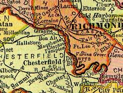
Granite was an unincorporated community in Chesterfield County, Virginia. It was originally located along the Richmond and Danville Railroad five miles west of Manchester and about a mile south of the rapids of the James River along Powhite Creek.
Wilberts Corner is an unincorporated community in Westmoreland County, in the U. S. state of Virginia.
The Hagerstown–Martinsburg Metropolitan Area, officially designated by the United States Office of Management and Budget (OMB) as Hagerstown–Martinsburg, Maryland–West Virginia Metropolitan Statistical Area (MSA), constitutes the primary cities of Hagerstown, Maryland, Martinsburg, West Virginia, and surrounding areas in three counties: Washington County, Maryland, Berkeley County, West Virginia, and Morgan County, West Virginia. The metro area lies mainly within the rich, fertile Cumberland and Shenandoah valleys, and is approximately a 60–90 minute drive from Washington, D.C., Baltimore, Maryland, and Harrisburg, Pennsylvania; Hagerstown is approximately 75 miles (121 km) driving distance from all three cities. The population of the metropolitan area as of 2008 is 263,753.

Stonybrook is a census-designated place (CDP) in York County, Pennsylvania, United States. The population was 2,384 at the 2010 census. The area was delineated as the Stonybrook-Wilshire CDP for the 2000 census.
Camp Hill is a summit in West Virginia, in the United States. With an elevation of 538 feet (164 m), Camp Hill is the 952nd highest summit in the state of West Virginia.


