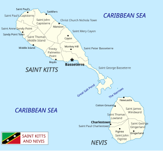
Saint Kitts and Nevis is a twin island country with a total landmass of just 270 square kilometres (104 sq mi). The island of St. Kitts, the larger of the two, is 180 square kilometres (68 sq mi) in size and is located at latitude 17.30 N, and longitude 62.80 W. Nevis is 93 square kilometres (36 sq mi) and located at latitude 17.10 N, longitude 62.35 W, approximately 3 km south-east of St. Kitts. The islands are about one-third of the way from Puerto Rico to Trinidad and Tobago. The islands are volcanic and mountainous.

Cape Fear is a prominent headland jutting into the Atlantic Ocean from Bald Head Island on the coast of North Carolina in the southeastern United States. It is largely formed of barrier beaches and the silty outwash of the Cape Fear River as it drains the southeast coast of North Carolina through an estuary south of Wilmington. Cape Fear is formed by the intersection of two sweeping arcs of shifting, low-lying beach, the result of longshore currents which also form the treacherous, shifting Frying Pan Shoals, part of the Graveyard of the Atlantic.

Baffin Bay, located between Baffin Island and the west coast of Greenland, is a marginal sea of the North Atlantic Ocean. It is connected to the Atlantic via Davis Strait and the Labrador Sea. The narrower Nares Strait connects Baffin Bay with the Arctic Ocean. The bay is not navigable most of the year because of the ice cover and high density of floating ice and icebergs in the open areas. However, a polynya of about 80,000 km2 (31,000 sq mi), known as the North Water, opens in summer on the north near Smith Sound. Most of the aquatic life of the bay is concentrated near that region.

The Northeast Cape Fear River is a blackwater river tributary of the Cape Fear River, approximately 130 mi (209 km) long, in southeastern North Carolina in the United States.

Trask Coliseum, is a 5,200-seat multi-purpose arena in Wilmington, North Carolina.
The Arthur Ashe Athletic Center is a 6,000 seat multi-purpose arena in Richmond, Virginia. It was built in 1982. It hosts local sporting events and concerts. It is named after former tennis player and Richmond resident Arthur Ashe.

The Wilmington Sea Dawgs are a professional basketball team and founding member of the Tobacco Road Basketball League. The team is based in Wilmington, North Carolina, and began play in 2006 as a member of the American Basketball Association. The team later played as a founding member of the Premier Basketball League and a founding member of the Continental Basketball League. In 2013, they will play at Blizzard Athletics, having previously played at the Joe and Barbara Schwartz Center on the campus of Cape Fear Community College.
Sarecta was the first incorporated town in Duplin County, North Carolina, established in 1787. In 1736, Duplin County was the destination of several hundred Ulster Scots (Scotch-Irish) and a handful of Swiss Protestants. They settled on a plot of land, 71,160 acres between the N. E. Cape Fear River and Black River, obtained from the Crown by Henry McCulloh Esq. of London. Their first settlements were Soracta (Sarecta) on the Northeast Cape Fear, an area at the lower end of Goshen Swamp, and the grove where the Duplin County Courthouse now stands.
Orange Pavilion is a multi-purpose arena on the grounds of the NOS Events Center in San Bernardino, California. It seats 5,000 spectators and is best known for hosting the National Orange Show Festival.

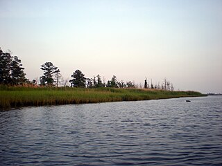
Cape Fear is a coastal plain and Tidewater region of North Carolina centered about the city of Wilmington. The region takes its name from the adjacent Cape Fear headland, as does the Cape Fear River which flows through the region and empties into the Atlantic Ocean near the cape. Much of the region's populated areas are found along the Atlantic beaches and the Atlantic Intracoastal Waterway, while the rural areas are dominated by farms and swampland like that of the Green Swamp. The general area can be also identified by the titles "Lower Cape Fear", "Wilmington Metropolitan Area", "Southeastern North Carolina", and "Azalea Coast". The latter name is derived from the North Carolina Azalea Festival held annually in Wilmington. Municipalities in the area belong to the Cape Fear Council of Governments.
The Schwartz Center may refer to:

Onslow Bay is an indentation of the North Carolina coast, between Cape Fear in the south and Cape Lookout in the north. Thirteen barrier islands form the shore of the bay. It is part of the open Atlantic Ocean and affords no protection from oceanic swells.

Cape Perpetua is a large forested headland projecting into the Pacific Ocean on the central Oregon Coast in Lincoln County, Oregon. The land is managed by the United States Forest Service as part of the Siuslaw National Forest.
Rocky Point is a census-designated place and unincorporated community in southern Pender County, North Carolina, United States. It is part of the Wilmington Metropolitan Statistical Area. Rocky Point is situated on North Carolina Highway 210, North Carolina Highway 133 and U.S. Route 117, at an elevation of 39 feet.

Fort Anderson is a mid 19th century earthen fort in the lower Cape Fear Region of North Carolina, located over the ruins of the colonial town of Brunswick in Brunswick County. It was used as a Confederate Fort during the American Civil War. The fort was pivotal in protecting the Cape Fear River inlets and Wilmington upstream. Earthen batteries comprise the fort and were used as platforms and shields for the Confederate cannons. Beneath some of the earthworks were "bombproofs," shelters used by troops during enemy bombardment. The Confederacy decided to build forts around the Cape Fear River to protect the port of Wilmington from the Union blockade. During the Civil War, blockade runners brought supplies such as iron, guns, and ammunition to the Confederacy. The purpose of the fort was to hinder movement of Union ships, and to serve as a dropping off point for blockade runners fortunate enough to make it up the mouth of the Cape Fear River. Fort Anderson was built on the ruins of Brunswick Town and was originally named Fort St. Philip, after the ruins of the Revolutionary period church nearby. The name was changed to honor Col. George B. Anderson.

Military Ocean Terminal Sunny Point (MOTSU) is one of the largest military terminals in the world. It serves as a transfer point between rail, trucks, and ships for the import and export of weapons, ammunition, explosives and military equipment for United States Army. The 596th Transportation Brigade, United States Army, operates the terminal.

Pender Early College High School, also known as PEC or PECHS, is a school in Burgaw, North Carolina, USA, created by the Early College High School Initiative, sponsored by the New Schools Project. Pender County Schools and Cape Fear Community College maintain the school, which is situated on the Burgaw Campus of Cape Fear Community College. It had its first graduating class in May 2010.
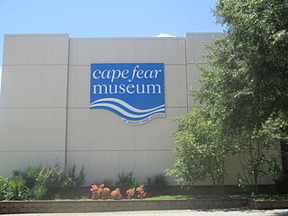
Cape Fear Museum of History and Science is a museum located at 814 Market Street in downtown Wilmington in southeastern North Carolina. Founded in 1898, it is the oldest history museum in the state.
The Brunswick River in North Carolina runs for 14 miles along the west bank of Eagle Island near the city of Leland. The Brunswick River is a fork of the Cape Fear River; the river starts as an offshoot of the Cape Fear River at the town of Navassa and flows back into the Cape Fear River at the southern tip of Eagle Island. Mill Creek and Alligator Creek flow into the Brunswick River.


