
Armenia is a landlocked country in West Asia, situated in the Transcaucasus region of the South Caucasus, bordered on the north and east by Georgia and Azerbaijan and on the south and west by Iran, Azerbaijan's exclave Nakhchivan, and Turkey.

The country of Brazil occupies roughly half of South America, bordering the Atlantic Ocean. Brazil covers a total area of 8,514,215 km2 (3,287,357 sq mi) which includes 8,456,510 km2 (3,265,080 sq mi) of land and 55,455 km2 (21,411 sq mi) of water. The highest point in Brazil is Pico da Neblina at 2,994 m (9,823 ft). Brazil is bordered by the countries of Argentina, Bolivia, Colombia, Guyana, Paraguay, Peru, Suriname, Uruguay, Venezuela, and France.

Ghana is a West African country in Africa, along the Gulf of Guinea, just a few degrees north of the equator.
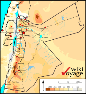
Jordan is situated geographically in Southwest Asia, south of Syria, west of Iraq, northwest of Saudi Arabia, east of Israel. The area is also referred to as the Middle or Near East. The territory of Jordan now covers about 91,880 square kilometres (35,480 sq mi).
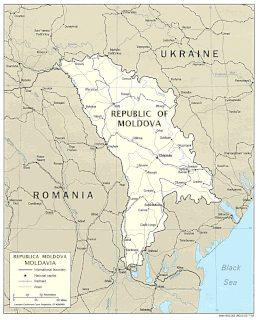
Located in Eastern Europe, Moldova is bordered on the west and southwest by Romania and on the north, south, and east by Ukraine. Most of its territory lies in Bessarabia region, between the area's two main rivers, the Nistru and the Prut. The Nistru forms a small part of Moldova's border with Ukraine in the northeast and southeast, but it mainly flows through the eastern part of the country, separating Bessarabia and Transnistria. The Prut River forms Moldova's entire western boundary with Romania. The Danube touches the Moldovan border at its southernmost tip, and forms the border for 200 metres (656 ft).

Mongolia is a landlocked country in Central Asia and East Asia, located between China and Russia. The terrain is one of mountains and rolling plateaus, with a high degree of relief. The total land area of Mongolia is 1,564,116 square kilometres. Overall, the land slopes from the high Altai Mountains of the west and the north to plains and depressions in the east and the south. The Khüiten Peak in extreme western Mongolia on the Chinese border is the highest point. The lowest point is at 560 m (1,840 ft), is the Hoh Nuur or lake Huh. The country has an average elevation of 1,580 m (5,180 ft).
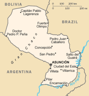
Paraguay is a country in South America, bordering Brazil, Argentina and Bolivia. The Paraguay River divides the country into strikingly different eastern and western regions. Both the eastern region and the western region gently slope toward and are drained into the Paraguay River, which separates and unifies the two regions. With the Paraneña region reaching southward and the Chaco extending to the north, Paraguay straddles the Tropic of Capricorn and experiences both subtropical and tropical climates.

Russia is the largest country in the world, covering over 17,125,192 km2, and encompassing more than one-eighth of Earth's inhabited land area. Russia extends across eleven time zones, and has the most borders of any country in the world, with sixteen sovereign nations.

The Altai Mountains, also spelled Altay Mountains, are a mountain range in Central and East Asia, where Russia, China, Mongolia and Kazakhstan converge, and where the rivers Irtysh and Ob have their headwaters. The massif merges with the Sayan Mountains in the northeast, and gradually becomes lower in the southeast, where it merges into the high plateau of the Gobi Desert. It spans from about 45° to 52° N and from about 84° to 99° E.

Ethiopia is located in the Horn of Africa. It is bordered by Eritrea to the north, Djibouti and Somalia to the east, Sudan and South Sudan to the west, and Kenya to the south. Ethiopia has a high central plateau that varies from 1,290 to 3,000 m above sea level, with the highest mountain reaching 4,620 m (15,157 ft).

The Yana is a river in Sakha in Russia, located between the Lena to the west and the Indigirka to the east.

The Putorana Plateau or the Putorana Mountains is a mountainous area in the Russian Federation. It is a large massif or plateau crossed by mountain ranges. The nearest large settlement is Norilsk, where foreign travel is restricted. The city is served by Alykel Airport.
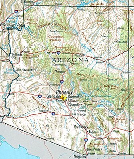
Arizona is a landlocked state situated in the southwestern region of the United States of America. It has a vast and diverse geography famous for its deep canyons, high- and low-elevation deserts, numerous natural rock formations, and volcanic mountain ranges. Arizona shares land borders with Utah to the north, the Mexican state of Sonora to the south, New Mexico to the east, and Nevada to the northwest, as well as water borders with California and the Mexican state of Baja California to the southwest along the Colorado River. Arizona is also one of the Four Corners states and is diagonally adjacent to Colorado.
The Moldavian Plateau is a geographic area of the historical region of Moldavia, spanning nowadays east and northeast of Romania, most of Moldova, and most of the Chernivtsi Oblast of Ukraine.

The Gobi Desert is a large desert or brushland region in East Asia, and is the sixth largest desert in the world.

Ussurisky Nature Reserve is a Russian 'zapovednik' that protects one of the remaining virgin mixed deciduous-conifer forests in the Primorsky (Maritime) region of the Russian Far East. The mountainous terrain is located on a southern spur of the Sikhote-Alin Mountains, in the upper reaches of the Komarovka River, about 50 km northeast of the city of Vladivostok. The reserve is named after Vladimir L. Komarov, an important early botanist and early explorer of the Primorsky region. The Ussursisky Reserve is situated in the Shkotovsky District of Primorsky Krai.

Tigirekskiy Nature Reserve is a Russian 'zapovednik' in the northwest mid-level mountains of the Altai-Sayan region. The reserve was established for the protection and study of the relic pre-glacial dark taiga of the higher elevations, and the mountain-steppe of the river valleys and lower regions. The site features extensive karst landscape and caves. The reserve is situated in the Zmeinogorsky, Tretyakovsky and Krasnoshchyokovsky districts of Altai Krai. It was formally established in 1999, and covers a total area of 40,693 ha (157.12 sq mi).

The Anabar Plateau is a mountain plateau in Krasnoyarsk Krai and the Sakha Republic (Yakutia), Siberia, Russia.

The Central Yakutian Lowland or Central Yakutian Lowlands, also known as Central Yakut Plain or Vilyuy Lowland, is a low alluvial plain in Siberia, Russia.

The East Siberian Mountains or East Siberian Highlands are one of the largest mountain systems of the Russian Federation. They are located between the Central Yakutian Lowland and the Bering Strait in the Far Eastern Federal District and Northeast Siberia. The whole area of the East Siberian System has a very low population density. The territory of the mountain system is one of the Great Russian Regions.
