KB, kB or kb may stand for:

Great Barrier Island lies in the outer Hauraki Gulf, New Zealand, 100 kilometres (62 mi) north-east of central Auckland. With an area of 285 square kilometres (110 sq mi) it is the sixth-largest island of New Zealand and fourth-largest in the main chain. Its highest point, Mount Hobson, is 627 metres (2,057 ft) above sea level. The local authority is the Auckland Council.

The national parks of New Zealand are protected natural areas administered by the Department of Conservation (DOC). The first national parks established in the country were all focused on mountain scenery. Since the 1980s the focus has been on developing a more diverse representation of New Zealand landscapes. The parks are all culturally significant and many also contain historic features. Tongariro National Park is one of the World Heritage Sites that are of both cultural and natural significance, while four of the South Island national parks form Te Wahipounamu, another World Heritage Site. There are currently 13 national parks; a 14th, Te Urewera National Park, was disestablished in 2014.

Agathis australis, commonly known by its Māori name kauri, is a coniferous tree in the family Araucariaceae, found north of 38°S in the northern regions of New Zealand's North Island.

Agathis, commonly known as kauri or dammara, is a genus of 22 species of evergreen tree. The genus is part of the ancient conifer family Araucariaceae, a group once widespread during the Jurassic and Cretaceous periods, but now largely restricted to the Southern Hemisphere except for a number of extant Malesian Agathis.
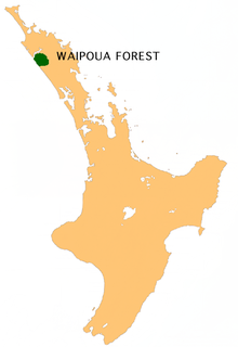
Waipoua Forest is a forest, on the west coast of the Northland Region of New Zealand's North Island. It preserves some of the best examples of kauri forest remaining in New Zealand. It is notable for having two of the largest living kauri trees, Tāne Mahuta and Te Matua Ngahere.

Kaipara Harbour is a large enclosed harbour estuary complex on the north western side of the North Island of New Zealand. The northern part of the harbour is administered by the Kaipara District and the southern part is administered by the Auckland Council. The local Māori tribe is Ngāti Whātua.

The Hunua Ranges is a mountain range and regional park to the southeast of Auckland city, in the Auckland and Waikato regions of New Zealand's North Island. The ranges cover some 250 square kilometres (97 sq mi) and rise to 688 metres (2255 ft) at Kohukohunui.
Tāne Mahuta, also called "God of the Forest", is a giant kauri tree in the Waipoua Forest of Northland Region, New Zealand. Its age is unknown but is estimated to be between 1,250 and 2,500 years. It is the largest living kauri tree known to stand today. It is named for the Māori god of forests and of birds.

Te Matua Ngahere is a giant kauri coniferous tree in the Waipoua Forest of Northland Region, New Zealand. The tree's Māori name means "Father of the Forest". Although not as massive or tall as its neighbour Tāne Mahuta, Te Matua Ngahere is stouter, with a girth just over 16 metres (52 ft). It is believed to be the second largest living kauri tree, and to have the biggest girth of any kauri in the country. According to The New Zealand Herald, it has the biggest girth of any tree in New Zealand.
Tane or Tāne may refer to:
Kauri gum is resin from kauri trees, which historically had several important industrial uses. It can also be used to make crafts such as jewellery. Kauri forests once covered much of the North Island of New Zealand, before the arrival of people caused deforestation, causing several areas to revert to sand dunes, scrubs, and swamps. Even afterwards, ancient kauri fields continued to provide a source for the gum and the remaining forests.
A. australis may refer to:
The Kauri Museum is in the west coast village of Matakohe, Northland, New Zealand. The museum, to the south of the Waipoua Forest, contains many exhibits that tell the story of the pioneering days when early European settlers in the area extracted kauri timber and kauri gum.

Kauri dieback is a forest dieback disease of the native kauri trees of New Zealand that is suspected to be caused by the oomycete Phytophthora agathidicida. Symptoms can include root rot and associated rot in a collar around the base of the tree, bleeding resin, yellowing and chlorosis of the leaves followed by extensive defoliation, and finally, death.

Aotea Conservation Park is a 12,300 hectare protected area on Great Barrier Island in New Zealand's Hauraki Gulf. It was established in 2015, and comprises 43 percent of the island.

Mystic is an environmental teen drama New Zealand television series produced by Libertine Pictures and Slim film+television for CBBC, TVNZ and the Seven Network.
Bruce William Hayward is a New Zealand geologist, marine ecologist, and author. He is known as a leading expert on living and fossil foraminifera.

The Swanson Stream is a stream of the Auckland Region of New Zealand's North Island. It flows north-east from its source the Waitākere Ranges through rural West Auckland towards the suburb of Swanson, before joining the Momutu Stream, which exits into Te Wai-o-Pareira / Henderson Creek and the western the Waitematā Harbour. Since the mid-2000s has been forested with native flora.