
Arunachal Pradesh is an Indian state in the Northeast. It was formed from the erstwhile North-East Frontier Agency (NEFA) region, and became a state on 20 February 1987. Itanagar is the state capital and its largest town. It

Changlang district (Pron:/tʃæŋˈlæŋ/) is located in the Indian state of Arunachal Pradesh, located south of Lohit district and north of Tirap district. Naga people reside here. As of 2011 it is the second most populous district of Arunachal Pradesh, after Papum Pare. It has become one of the major districts in the area owing to the presence of crude oil, coal and mineral resources other than tourism and hydropower.

The Tangshang people, also known as the Tangsa Naga, are a Tibeto-Burmese ethnic group inhabiting the Northeast Indian states of Arunachal Pradesh and Assam, and across the border in Sagaing Region and parts of Kachin State of Myanmar. The Tangshang people in Myanmar were formerly known as Rangpang, Pangmi, and Heimi/Haimi. Tangshang/Tangsa is the largest Naga ethnic group having an approximate population of 450,000. Their language is called Naga-Tase in the Ethnologue and Tase Naga in the ISO code (ISO639-3:nst). They are a scheduled group under the Indian Constitution and there are many sub-groups within Tangsa on both sides of the border.
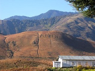
Anini is the headquarters of the Dibang Valley district in the state of Arunachal Pradesh in Northeast India. Anini was also the district headquarters of the undivided Dibang Valley district. Most of this location's population consists of the Idu Mishmi tribal people. Due to its remote location, Anini remains a small and underdeveloped town. However, it still has basic road and air links to the rest of India. The town is fully dependent on the nearest major settlement, Roing, which is in the Lower Dibang Valley District, for most commercial needs.
Tezu is a census town and the headquarters of Lohit district in the Indian state of Arunachal Pradesh. It is the fifth largest town in Arunachal Pradesh and one of its most developed.

Dibrugarh district (Pron:ˌdɪbru:ˈgor:) is an district in the state of Assam in India. The district headquarters are located within the city of Dibrugarh.

Pangsau Pass or Pan Saung Pass, 3,727 feet (1,136 m) in altitude, lies on the crest of the Patkai Hills on the India–Myanmar border. The pass offers one of the easiest routes into Burma from the Assam plains. It is named after the closest Burmese village, Pangsau, that lies 2 km beyond the pass to the east. To the east of Pangsau Pass, India's undisputed easternmost point "Chaukan Pass" lies and to the east of Vijaynagar in the Changlang district.

Namrup is a small town situated close to the foothills of the Patkai Hills in the extreme southeastern part of Assam, India. The river Dihing or Disang flows through it. Namrup is situated in amidst wet-paddy fields, indigenous Assamese villages, orchards, large tea-gardens and densely forested hills. Administratively Namrup is located within Dibrugarh district and is today an important industrial town of Assam. Namrup is approximately 75 km from Dibrugarh by road towards the south-east and approximately 50 km from Tinsukia towards the south. It is also a small railway station in Dibrugarh-Guwahati broad-gauge railway line. The nearest airport is Dibrugarh located at a distance of approximately 70 km. Other urban areas close to Namrup are Naharkatiya - 18 km, Duliajan - 35 km, Sonari - 20 km, Moran - 55 km, etc. by roadways. Namrup is located around 500 km east of Guwahati, the largest city in the North East Region.
Changlang is a census town and headquarters of the Changlang district in the Indian state of Arunachal Pradesh. It has become one of the major districts in the area owing to the presence of crude oil, coal and mineral resources other than tourism and hydro power.

Duliajan is an industrial town of Dibrugarh district in the Indian state of Assam located in the upper north-east corner of India. The town is about 45 km east of Dibrugarh City. It is particularly known for its oil related industry, Oil India Limited, one of the country's largest oil and gas companies. There is also other central government owned companies like B.C.P.L. GDU Station, N.E.E.P.C.O., D.N.P.L., LPG Plant and the Shivani company which is India's largest private company for drilling. Assam Gas Company Limited, which carries out business related to natural gas in India owned by the Government of Assam, is also located in this township.
Jairampur is a census town in Changlang district in the Indian state of Arunachal Pradesh.

Roing is the district headquarter of Lower Dibang Valley district in the Indian state of Arunachal Pradesh. It is the last major township at the north-eastern frontier of India.
The Tutsa people, also known as the Tutsa Naga, are a Tibeto-Burmese ethnic group inhabiting the western parts of Changlang and Khimiyong circles and the eastern part of Tirap districts of the Northeast Indian state of Arunachal Pradesh. Ethnically, the Tutsa are closely related to the Tangsa and were classified as members of the Tangsa in all census records until 1981. As of 2001 their population stood at 25,000.
Jonai is a Sub-Division of Dhemaji District in India's Assam State.

Upper Assam is an administrative division of the state of Assam comprising the undivided Lakhimpur and Sivasagar districts, of the upper reaches of the Brahmaputra valley. The other divisions are: Lower Assam, North Assam and Hills and Barak Valley. The division is under the jurisdiction of a Commissioner, stationed at Jorhat.
The Muklom sub-tribe is a subgroup of the Tangsa community, predominantly residing in the Khimyang and Kharsang circles of Arunachal Pradesh, India. With a population of approximately 15,000, the Muklom people are known for their rich cultural heritage, traditions, and arts and crafts.

Tangsa, also known as Tase and Tase Naga, is a Sino-Tibetan language or language cluster spoken by the Tangsa people of Burma and north-eastern India. Some varieties, such as Shangge (Shanke), are likely distinct languages. There are about 60,000 speakers in Burma and 40,000 speakers in India. The dialects of Tangsa have disparate levels of lexical similarity, ranging from 35%–97%.
Nampong is a census town in the Changlang District in the Indian state of Arunachal Pradesh. It is located close to the Pangsau Pass, being the last town on the Indian side, at an elevation of 308 metres. Nampong is one of the 60 constituencies of Arunachal. Name of current MLA (August-2016) of Nampong constituency is Laisam Simai.
Arunachal Frontier Highway (AFH), officially notified as the National Highway NH-913 and also called Bomdila-Vijaynagar Highway (BVH), connecting Bomdila Airstrip ALG & HQ in northwest to Vijaynagar Airstrip ALG & HQ in southeast via Nafra HQ-Sarli HQ-Huri Helipad ALG & HQ-Nacho HQ-Mechuka Airstrip ALG & HQ-Monigong HQ-Jido -Hunli HQ-Hayuliang Airstrip ALG HQ-Chenquenty-Hawai HQ-Miao HQ including 800 km greenfield section and network of new tunnels & bridges, is a 2-lane paved-shoulder under-construction national highway along the India-China LAC-McMahon Line border in the Indian state of Arunachal Pradesh. The 1,748 km-long (1,086 mi) highway itself will cost ₹27,000 crore and total cost including 6 additional inter-corridors is ₹40,000 crore. In some places, this highway will run as close as 20 km from the LAC. To be constructed by MoRTH in 9 packages, all packages will be approved by the end of fy 2024-25 and construction will be completed in 2 years by 31 March 2027. Of the total route, 800km is greenfield, rest brownfield will be upgraded and tunnels will be built. This highway in the north & east Arunachal along the China border, would complement the Trans-Arunachal Highway and the Arunachal East-West Corridor as major highways spanning the whole state, pursuing the Look East connectivity policy.
East-West Industrial Corridor Highway of Arunachal Pradesh, a 2-lane and 966.78 km long including existing 274.20 km Pasighat-Manmao route, is a proposed highway across lower foothills of Arunachal Pradesh state in India from Bhairabkunda in Assam at tri-junction of Bhutan-Assam-Arunachal Pradesh in west to Kanubari tri-junction of Nagaland-Assam-Arunachal Pradesh in east.

