
Bulawayo is the second largest city in Zimbabwe, and the largest city in the country's Matabeleland region. The city's population is disputed; the 2022 census listed it at 665,940, while the Bulawayo City Council claimed it to be about 1.2 million. Bulawayo covers an area of about 546 square kilometres in the western part of the country, along the Matsheumhlope River. Along with the capital Harare, Bulawayo is one of two cities in Zimbabwe that is also a province.

Mutare, originally known as Umtali, is the most populous city in the province of Manicaland, and the third most populous city in Zimbabwe, having surpassed Gweru in the 2012 census, with an urban population of 224,802 and approximately 260,567 in the surrounding districts giving the wider metropolitan area a total population of over 500,000 people. Mutare is also the capital of Manicaland province and the largest city in Eastern Zimbabwe.

Gweru, originally known as Gwelo, is a city in central Zimbabwe. Near the geographical centre of the country. It is on the centre of Midlands Province. Originally an area known to the Ndebele as "The Steep Place" because of the Gweru River's high banks, in 1894 it became the site of a military outpost established by Leander Starr Jameson. In 1914 it attained municipal status, and in 1971 it became a city.
Chegutu, originally known as Hartley, is a town in Mashonaland West Province, Zimbabwe.

Beitbridge is a border town in the province of Matabeleland South, Zimbabwe. The name also refers to the border post and bridge spanning the Limpopo River, which forms the political border between South Africa and Zimbabwe. The border on the South African side of the river is also named Beitbridge.

Insiza District is one of the seven districts located in the province of Matabeleland South of Zimbabwe. It is a rural area. Insiza District lies to the South East of Bulawayo in Zimbabwe and borders Gwanda District to the South, Zvishavane District to the east, and Umzingwane District to the West. The total distance between Insiza and Bulawayo is 77 km and 469 km from Harare. The district is mostly in natural region four. This region experiences fairly low total rainfall (450–650 mm) and is subject to periodic seasonal droughts and severe dry spells during the rainy season. The rainfall is too low and uneven for cash cropping except in certain very favourable localities, where limited drought resistant crops can afford a side-line. The farming system, in accord with natural factors, should be based on livestock production, but it: can be intensified to some extent by the growing of drought resistant fodder crops.
Esigodini, originally known as Essexvale, is a town in the Matabeleland South Province of Zimbabwe. It is the administrative centre for Umzingwane District, one of the seven administrative districts in Matabeleland South. It was originally an estate of Frederick Selous.
Killarney Heights is a suburb of Northern Sydney, situated on Middle Harbour, in the state of New South Wales, Australia. Killarney Heights is 12 kilometres north-east of the Sydney central business district in the local government area of Northern Beaches Council. Killarney Heights is part of the Forest District, colloquially known as The Forest.

West Nicholson or Tshabezi is a town in the Matabeleland South Province of Zimbabwe.
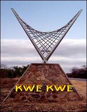
Kwekwe, originally known as Que Que, is a city in the Midlands province of central Zimbabwe. The city has a population of 119,863 within the city limits, as of the 2022 census, making it the 7th-largest city in Zimbabwe and the second-most populous city in the Midlands, behind Gweru.
Colleen Bawn is a town in Zimbabwe.

Kadoma, originally known as Gatooma, is a town in Zimbabwe.
Dete is a small railway re-crewing depot and a developing town on the Bulawayo-Hwange-Victoria Falls railway line in Zimbabwe, approximately 300 km (190 mi) north-west of Bulawayo and 67 km (42 mi) south-east of Hwange, lying within the Hwange National Park.
Mzilikazi High School, is a government-maintained F1 secondary school named in recognition of the Ndebele king Mzilikazi, the founder of the Ndebele Nation. The School is in the city of Bulawayo, Zimbabwe, located along the Old Falls Road, a road that used to link Bulawayo with the Victoria Falls. It is located very close to the famous Mpilo Hospital of Bulawayo. Mzilikazi High School is physically located between Greenspan Suburb and Mzilikazi Township.
ZSM is a leading training institution, whose mandate is pivotal to the socio-economic development of Zimbabwe. Close to a century, from inception in 1926 the School still prides itself in producing competent mining practitioners extremely in demand in the SADC region and internationally. ZSM is renowned for its uniqueness, dynamism and vibrancy in the mining industry. The school is located in Killarney, Bulawayo. Zimbabwe School of mines mainly offers qualification in National Diploma and Higher National Diploma in the following areas of Mining, Mine Geology, Mine Survey, Mining Mineral Processing & Extractive Metallurgy and Metallurgical Assaying. The curriculum constantly is revised and updated with help from partner mining companies in Zimbabwe and Southern Africa.
Pelandaba is a suburb of Bulawayo in Zimbabwe. It has nearly 30,000 residents as of 2007. It houses Sizane Secondary School, Induba Primary School and the house of late Joshua Nkomo, the former leader of Zimbabwe's African Peoples Union.
The A5 Highway is a national road in Zimbabwe. It joins the cities of Harare and Bulawayo, and is hence known as the Harare-Bulawayo Highway. It is one of the two routes that form the R2 Route, which connects Harare with the Plumtree Border with Botswana.
Nketa is a high-density suburb in the city of Bulawayo, Zimbabwe. The suburb is divided into sections from Nketa 6 to Nketa 9. It started its development in the early 1990s and the major portion of the suburb was built using loans. It boasts of a library and clinic and a good number of primary and high schools.

Callistus Dingiswayo Ndlovu was a Zimbabwean academic, diplomat, and politician. He joined the Zimbabwe African People's Union (ZAPU) in 1963 as a teacher in Matabeleland, and went on to serve as its representative to the United Nations and North America in the 1970s. After Zimbabwe's independence in 1980, he was a member of the House of Assembly from 1980 to 1985 and served as a senator from 1985 to 1990. He left ZAPU and joined the ruling ZANU–PF party in 1984.
