
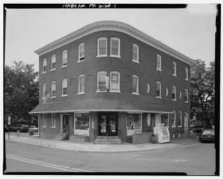
Warminster Heights is a census-designated place and part of Warminster Township in Bucks County, Pennsylvania, USA. It is located near the east border of Hatboro, Montgomery County, Pennsylvania. The population was 4,124 at the 2010 census.

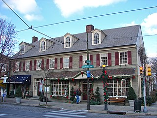
Jenkintown is a borough in Montgomery County, Pennsylvania, about 10 miles (16 km) north of Center City Philadelphia.
North Wales is a borough in Montgomery County, Pennsylvania, United States. It is a suburb of Philadelphia, and is one of the three historic population centers that make up the North Penn Valley, which is centered around the borough of Lansdale. The population was 3,229 as of the 2010 census.

Pottsville is a city in, and the county seat of, Schuylkill County, Pennsylvania, United States. The population was 14,324 at the 2010 census, and is the principal city of the Pottsville, PA Micropolitan Statistical Area. The city lies along the west bank of the Schuylkill River, 52 miles (84 km) south of Wilkes-Barre. It is located in Pennsylvania's Coal Region.
Chestnut Hill is a neighborhood in the Northwest Philadelphia section of the United States city of Philadelphia, Pennsylvania. It is known for the high incomes of its residents and high real estate values, as well as its private schools.

The Community College of Philadelphia is a public community college in Philadelphia, Pennsylvania. It grants associate degrees, academic certificates, and proficiency certificates. The college offers traditional, evening, weekend and online courses, including online degree programs.

Roxborough is a neighborhood in the Northwest section of the city of Philadelphia, Pennsylvania. It is bordered to the southwest, along the Schuylkill River, by the neighborhood of Manayunk, along the northeast by the Wissahickon Creek section of Fairmount Park, and to the southeast by the neighborhood of East Falls. Beyond Roxborough to the northwest is Montgomery County. Roxborough's ZIP code is 19128. Most of Roxborough is in Philadelphia's 21st Ward.

Northeast Philadelphia, nicknamed Northeast Philly, the Northeast and the Great Northeast, is a section of the City of Philadelphia, Pennsylvania. According to the 2000 Census, the Northeast has a sizable percentage of the city's 1.547 million people—a population of between 300,000 and 450,000, depending on how the area is defined. Beginning in the 1980s, many of the Northeast's middle class children graduated from college and settled in suburbs, especially nearby Bucks County. The Northeast is known as being home to a large working class Irish American population, but it is also home to Polish, German, Jewish, Italian, African American, Portuguese, Brazilian, Russian, Puerto Rican, and Dominican neighborhoods.

Overbrook is a neighborhood northwest of West Philadelphia, Philadelphia, in the U.S. state of Pennsylvania. The area's housing ranges from large, old homes to rowhouses to 3- and 4-story apartment buildings.

West Philadelphia, nicknamed West Philly, is a section of Philadelphia, Pennsylvania. Though there is no official definition of its boundaries, it is generally considered to reach from the western shore of the Schuylkill River, to City Avenue to the northwest, Cobbs Creek to the southwest, and the SEPTA Media/Elwyn Line to the south. An alternate definition includes all city land west of the Schuylkill; this would also include Southwest Philadelphia and its neighborhoods. The eastern side of West Philadelphia is also known as University City.
Lawncrest is a neighborhood in the "Near" (lower) Northeast Philadelphia, Pennsylvania. The name is an amalgam of Lawndale and Crescentville, the two primary communities that make up the neighborhood. The Philadelphia Inquirer does not consider Lawncrest to be a neighborhood.
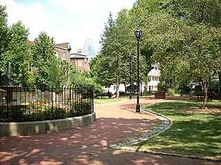
Fitler Square is a 0.5 acre public park in Philadelphia, Pennsylvania, bounded on the east by 23rd Street, on the west by 24th Street, on the north by Panama Street, and on the south by Pine Street. It is in the southwestern part of Philadelphia's Center City on land owned by City of Philadelphia via the Department of Parks and Recreation. Fitler Square was named for late 19th century Philadelphia mayor Edwin Henry Fitler shortly after his death in 1896. The Square is cared for through a public private partnership between the Department of Parks and Recreation and the Fitler Square Improvement Association.
The Bustleton section of Northeast Philadelphia is located in the Far Northeast, north of Rhawnhurst and Fox Chase and south of Somerton; sitting between Roosevelt Boulevard to the east, the city boundary to the west, Tomlinson Road to the north, and Pennypack Park to the south, it is centered at the intersection of Grant Avenue and Bustleton Avenue (PA-532) and is completely included in the 19115 postal ZIP code.

Southwest Philadelphia is a section of Philadelphia, Pennsylvania, United States. The section can be described as extending from the western side of the Schuylkill River to the city line, with the SEPTA. The northern border is defined by the Philadelphia City Planning Commission as east from the city line along Baltimore Avenue moving south along 51st Street to Springfield Ave. It follows the train tracks until 49th Street. From 49th and Kingsessing Ave the line moves east along Kingsessing Ave. The line then moves south along 46th St to Paschall Ave where it jogs to join Grays Ferry where the line runs to the Schuylkill River.
Elmwood Park, also known simply as Elmwood, is a neighborhood in the Southwest section of Philadelphia, Pennsylvania, United States. It borders the city line with Delaware County at Cobbs Creek, and extends to the Schuylkill River. The Eastwick neighborhood borders it to the southwest, and Kingsessing borders it on the northeast.
Oxford Circle is a neighborhood in the lower Northeast section of Philadelphia, Pennsylvania, United States. Its namesake is the much used traffic circle at Roosevelt Boulevard and Oxford Avenue. The Oxford Circle neighborhood has traditionally included the areas up to Rhawnhurst and Mayfair but does not really have a fixed boundary other than in publications about Philadelphia which are of a public relations or informational nature.

St. Francis de Sales Roman Catholic Church, founded in 1890, is a Catholic church at 4625 Springfield Avenue in Philadelphia, Pennsylvania, part of the Roman Catholic Archdiocese of Philadelphia. Its cornerstone laid in 1907, the Guastavino tiled dome of the de Sales parish has been an icon in its neighborhood. The de Sales parish was designed by Philadelphia architect Henry D. Dagit, built in the Byzantine Revival style and incorporates a Guastavino tile dome modeled on that of Istanbul's Hagia Sophia and elements of the Arts and Crafts movement which was at its peak when the church was built.

Castor Gardens is a neighborhood in the lower Northeast section of Philadelphia, Pennsylvania, United States. Castor Gardens' borders are ill-defined, but it exists in the vicinity of Castor Avenue and Cottman Avenue. It is also near Roosevelt Boulevard. The neighborhood can either be entered from the south, by taking the Oxford Circle exit of Roosevelt Boulevard, or from the north, by taking the Cottman Avenue exit. Adjacent neighborhoods are Mayfair, Lawndale, Burholme, Oxford Circle, and Rhawnhurst.
The Great Valley is a west-to-east valley through the center of Chester County, Pennsylvania, United States. It is also sometimes referred to as Chester Valley, and both names are in use throughout the region. The valley stretches from the Schuylkill River in Montgomery County in the east, southwesterly through Chester and Lancaster counties. The valley is most distinct in central Chester County, although traces of it can be followed almost the entire distance between the Delaware and Susquehanna rivers.

Olney-Oak Lane, Philadelphia, is a section of Philadelphia that is immediately north of Upper North Philadelphia and south of Cheltenham. It is an area that consists of the now defunct township that was called "Bristol Township, Philadelphia County, Pennsylvania". The section is often included as part of North Philadelphia by city government agencies, though locally it is often referred to as "Uptown," along with the Germantown-Chestnut Hill section.