Ruonala is a suburb in southern Finland at Kotka. Ruonala is also a family-name in Finland, found mainly near the cities of Kotka and Oulu.
Martin Glacier is a glacier, 3 nautical miles (6 km) wide and 9 nautical miles (17 km) long, which flows west and then northwest from the south side of Mount Lupa to the southeast corner of Rymill Bay where it joins Bertrand Ice Piedmont, on the west coast of Graham Land, Antarctica. It was first surveyed in 1936 by the British Graham Land Expedition (BGLE) under John Riddoch Rymill, and was resurveyed in 1948–1949 by the Falkland Islands Dependencies Survey. The glacier was named for James H. Martin, a member of the British Australian and New Zealand Antarctic Research Expedition (1929–1931) under Sir Douglas Mawson, and first mate of the Penola during the BGLE.

Tennyson is a suburb of Adelaide, South Australia.
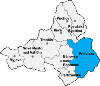
Čavoj is a village and municipality in Prievidza District in the Trenčín Region of western Slovakia.
Zuidwijk is a former municipality in the Dutch province of South Holland. It was located southeast of the center of Boskoop.

The Battle of Llucmajor occurred in 1349 when Peter IV of Aragon's forces defeated and killed his cousin James III of Majorca in the town of Llucmajor on the Balearic Islands, resulting in the end of the independent Kingdom of Majorca.
Genuang is a small town in Segamat District, Johor, Malaysia. The town is situated near Segamat.

Lăpugiu de Jos is a commune in Hunedoara County, Romania. It is composed of ten villages: Baștea (Bástya), Cosești (Kosesd), Fintoag (Fintóág), Grind (Gerend), Holdea (Holgya), Lăpugiu de Jos, Lăpugiu de Sus (Felsőlapugy), Lăsău (Laszó), Ohaba (Ohába) and Teiu (Tyej).

Kamienica Górna is a village in the administrative district of Gmina Brzostek, within Dębica County, Subcarpathian Voivodeship, in south-eastern Poland. It lies approximately 6 kilometres (4 mi) east of Brzostek, 20 km (12 mi) south of Dębica, and 41 km (25 mi) south-west of the regional capital Rzeszów.
Gəlinqaya is a village in the municipality of Qabaqtəpə in the Dashkasan Rayon of Azerbaijan.
Wałków is a village in the administrative district of Gmina Koźmin Wielkopolski, within Krotoszyn County, Greater Poland Voivodeship, in west-central Poland. It lies approximately 7 kilometres (4 mi) north of Koźmin Wielkopolski, 23 km (14 mi) north of Krotoszyn, and 70 km (43 mi) south-east of the regional capital Poznań.
Stroumpi or Stroumbi is a small village in central Paphos District, Cyprus, and halfway between Paphos and Polis. The name of the village is said to derive from its founder, a man called "Stroumpos", or the shape of the surrounding hills. The village is known for its annual "Dionysia" wine festival named after Dionysos, the ancient Greek god of wine, that takes place at the end of August. A now-defunct "Dionysos" volleyball team was based in Stroumpi and played in the Cypriot top league.

Xuanhan County is a county in the northeast of Sichuan Province, China, bordering Chongqing to the east. It is under the administration of the prefecture-level city of Dazhou.
Konnitsi is a village in the municipality of Ivaylovgrad, in Haskovo Province, in southern Bulgaria.
Vivva is a village in Orava Parish, Põlva County in southeastern Estonia.
Junction Spur is a rocky spur marking the eastern extremity of the Darwin Mountains and the junction of Hatherton Glacier and Darwin Glacier. It was mapped and named by the Darwin Glacier party of the Commonwealth Trans-Antarctic Expedition (1956–58).
San Torcuato is a village in the province and autonomous community of La Rioja, Spain. The municipality covers an area of 10.82 square kilometres (4.18 sq mi) and as of 2011 had a population of 83 people.
Baneswara Temple is a Hindu temple in Balasore, Odisha, India. It is one of the oldest in the city. The temple is maintained by group of people called Pujaka.