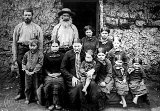
Boer is the Dutch and Afrikaans noun for "farmer". In South African contexts, "Boers" refers to the descendants of the then Dutch-speaking settlers of the eastern Cape frontier in Southern Africa during the 18th and much of the 19th century. From 1652 to 1795 the Dutch East India Company controlled this area, but the United Kingdom incorporated it into the British Empire in 1806.

The Cape of Good Hope, also known as the Cape Colony, was a British colony in present-day South Africa, named after the Cape of Good Hope. The British colony was preceded by an earlier Dutch colony of the same name, the Kaap de Goede Hoop, established in 1652 by the Dutch East India Company. The Cape was under Dutch rule from 1652 to 1795 and again from 1803 to 1806. The Dutch lost the colony to Great Britain following the 1795 Battle of Muizenberg, but had it returned following the 1802 Peace of Amiens. It was re-occupied by the UK following the Battle of Blaauwberg in 1806, and British possession affirmed with the Anglo-Dutch Treaty of 1814.
The protected areas of South Africa include national parks and marine protected areas managed by the national government, public nature reserves managed by provincial and local governments, and private nature reserves managed by private landowners. Most protected areas are intended for the conservation of flora and fauna. National parks are maintained by South African National Parks (SANParks). A number of national parks have been incorporated in transfrontier conservation areas.

South Africa occupies the southern tip of Africa, its coastline stretching more than 2,850 kilometres from the desert border with Namibia on the Atlantic (western) coast southwards around the tip of Africa and then northeast to the border with Mozambique on the Indian Ocean. The low-lying coastal zone is narrow for much of that distance, soon giving way to a mountainous escarpment that separates the coast from the high inland plateau. In some places, notably the province of KwaZulu-Natal in the east, a greater distance separates the coast from the escarpment. Although most of the country is classified as semi-arid, it has considerable variation in climate as well as topography.

The Eastern Cape is a province of South Africa. Its capital is Bhisho, but its two largest cities are Port Elizabeth and East London. It was formed in 1994 out of the Xhosa homelands or bantustans of Transkei and Ciskei, together with the eastern portion of the Cape Province. It is the landing place and home of the 1820 Settlers. The central and eastern part of the province is the traditional home of the Xhosa people.

Devil's Peak is part of the mountainous backdrop to Cape Town, South Africa. When looking at Table Mountain from the Victoria & Alfred Waterfront, or when looking at the standard picture postcard view of the mountain, the skyline is from left to right: the spire of Devil's Peak, the flat mesa of Table Mountain, the dome of Lion's Head and Signal Hill.

Ben Macdhui is a 3,001-metre (9,846 ft) mountain in the Eastern Cape province of South Africa. It was named after Ben Macdhui in Scotland. It is the highest peak in the Eastern Cape that is entirely within South Africa; Ben MacDhui is the highest pass in South Africa

Rondebosch is one of the Southern Suburbs of Cape Town, South Africa. It is primarily a residential suburb, with shopping and business districts as well as the main campus of the University of Cape Town.

The Langeberg Range is a mountain range in the Western Cape province of South Africa. Its highest peak is Keeromsberg at 2075m and 15 km NE of the town of Worcester. Some of the highest peaks of the range are located just to the north of Swellendam, in a subrange known as the Clock Peaks whose highest point is 1710 m high Misty Point. Local lore states one can tell the time by means of the shadows cast by the seven summits of the Clock Peaks.
Mowbray is one of the Southern Suburbs of Cape Town, South Africa and lies on the slopes of Devil's Peak. Mowbray is at a junction of several major Cape Town highways and has an important multi-modal public transport interchange at Mowbray railway station. Its original name was Driekoppen.

The Tsitsikamma mountains form an east-west mountain range located in the Garden Route region of the southern South African coast in the Western Cape and Eastern Cape provinces. Tsitsikamma means 'place of much water' in the Khoekhoe language.
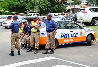
Law enforcement in South Africa is primarily the responsibility of the South African Police Service (SAPS), South Africa's national police force. SAPS is responsible for investigating crime and security throughout the country. The "national police force is crucial for the safety of South Africa's citizens" and was established in accordance with the provisions of Section 205 of the Constitution of South Africa.
Breede River Valley is a region of Western Cape Province, South Africa known for being the largest fruit and wine producing valley in the Western Cape, as well as South Africa's leading race-horse breeding area. It is part of the Boland bordering on becoming Little Karoo towards the east.

Compassberg, is a mountain peak of the Sneeuberge range in South Africa. It is located 55 km due north of Graaff-Reinet in the Eastern Cape Province. At 2504 metres, it is the highest peak in South Africa outside the Stormberg-Drakensberg massif. It was named by Colonel Robert Jacob Gordon when he accompanied Governor Joachim van Plettenberg on a journey to the eastern frontier of the Cape Colony in 1778.

The Bloukrans River is a short river located in the Tsitsikamma region of the Garden Route, South Africa. It is located on the border between the Western Cape and Eastern Cape provinces. The river mouth is located east of Nature's Valley, the Bloukrans Bridge spans the river near the mouth and the Bloukrans Pass is close by. The river originates near Peak Formosa in the Plettenberg Bay region.
The 2016–17 CSA Provincial One-Day Challenge was a List A cricket competition that took place in South Africa from 9 October 2016 to 2 April 2017. The competition was played between the thirteen South African provincial teams and Namibia. The tournament was played in parallel with the 2016–17 Sunfoil 3-Day Cup, a first-class competition which featured the same teams.
The 2018 Africa T20 Cup was the fourth edition of the Africa T20 Cup, a Twenty20 cricket tournament. It was held in South Africa in September 2018, as a curtain-raiser to the 2018–19 South African domestic season. Provincial side KwaZulu-Natal Inland were the defending champions.
The 2018–19 CSA 3-Day Provincial Cup was a first-class cricket competition that took place in South Africa from 4 October 2018 to 14 April 2019. This was the first edition of the tournament not to be sponsored by Sunfoil, after they decided not to renew their sponsorship.


