
The Kansas City metropolitan area is a 14 county metropolitan area anchored by Kansas City, Missouri, and straddling the border between the U.S. states of Missouri and Kansas. With a population of 2,104,509, it ranks as the second largest metropolitan area centered in Missouri. Alongside Kansas City, the area includes a number of other cities and suburbs, the largest being Overland Park, Kansas; Kansas City, Kansas; Olathe, Kansas; and Independence, Missouri; each over 100,000 in population. The Mid-America Regional Council (MARC) serves as the Council of Governments and the Metropolitan Planning Organization for the area.
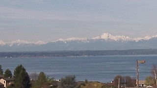
Broadview is a neighborhood in northwestern Seattle, Washington, USA.

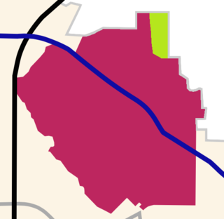
Lake Park Estates is a neighborhood in east Dallas, Texas (USA) on the north corner of the diagonal intersection of Buckner Road and Garland Road. It is bordered by the Casa Linda Shopping Center, Casa Linda Estates, Old Lake Highlands, Eastwood, and Dallas's White Rock Lake Park.
Sylvan-Highlands is a neighborhood of Portland, Oregon, United States located on the west side of the West Hills.
Crocker Highlands, a neighborhood of Oakland, California, overflows with an abundance of character and charm, described as having "the genteel ambiance of an old Hollywood movie set," is one of several distinct neighborhoods comprising a larger area collectively known as the "Lower Hills" that lies in between the 580 and 13 freeways.
Carole Highlands, Maryland is an unincorporated community located in Prince George's County, Maryland. Carole Highlands is contained between East West Highway to the south, University Boulevard to the north, Larch Avenue, Hopewell Avenue, and 15th Avenue to the west, and Riggs Road to the east. Carole Highlands borders the adjacent neighborhoods of Chillum, Green Meadows, Lewisdale, and Langley Park in Prince George's County, MD while bordering the city of Takoma Park in Montgomery County, MD. For statistical purposes, it is part of the Chillum census-designated place (CDP).
Old Lake Highlands is a neighborhood in east Dallas, Texas (USA). It is adjacent to White Rock Lake. It is in Dallas Council District 9.

Lyn-Lake is a commercial district in south Minneapolis. At the core is the intersection of Lake Street and Lyndale Avenue from which Lyn-Lake takes its name. This is also at the intersection of four Minneapolis neighborhoods: Whittier on the northeast, Lyndale on the southeast, Calhoun Area on the southwest, and Lowry Hill East on the northwest. Most residents who consider themselves part of the "Lyn-Lake neighborhood" originate from the southeast corner of the Lyndale neighborhood. Lyn-Lake was branded by the Lyn-Lake Business Association in 1999.

Bluffview is an upscale neighborhood in north Dallas, Texas (USA). It is bounded by Northwest Highway and the Preston Hollow neighborhood on the north, Inwood Road and the Devonshire neighborhood on the east, Lovers Lane and the Elm Thicket/North Park neighborhood on the south, and Midway Road, Bluebonnett Road, Bluff View Blvd., and the Shorecrest and Cochran's Chapel neighborhoods on the west.

Maryland Route 129 is a state highway in the U.S. state of Maryland, running north-northwesterly from Baltimore into Baltimore County, ending east of Reisterstown. The route leaves downtown on the one-way pair of McCulloh Street and Druid Hill Avenue, and then uses the entire length of Park Heights Avenue to the end. MD 129 connects Downtown Baltimore with Druid Hill Park using McCulloh Street and Druid Hill Avenue. As Park Heights Avenue, the state highway is one of two primary radial routes in the northwestern part of the city, providing access to The Maryland Zoo and Pimlico Race Course. In Baltimore County, MD 129 passes through Pikesville, where it has a junction with Interstate 695 (I-695) and serves an affluent rural area north of Pikesville and east of Reisterstown.

Alexander's village is a non-HOA neighborhood in the Lake Highlands area of Dallas, Texas (USA). The neighborhood is triangular in shape and is bounded by Abrams Road, Fair Oaks Avenue, and White Rock Creek. Walnut Hill Lane runs directly through the neighborhood.
Love Field is a neighborhood located in northwest Dallas, Texas (USA). It lies southwest of and is adjacent to Dallas Love Field Airport and is bounded by Denton Drive, Inwood Road, Harry Hines Boulevard, and Webb Chapel Extension. The neighborhood takes its name from Love Field Airport.
Highland Meadows is a neighborhood in Dallas, Texas, United States.
Lochwood is a neighborhood in east Dallas, Texas (USA) adjacent to Lake Park Estates and Old Lake Highlands. It is located east of White Rock Lake and sometimes referred to as 'Dixon Branch' because of the creek by that name running through the neighborhood.

North Dallas is an area of numerous communities and neighborhoods in Dallas, Texas. The phrase "North Dallas" is also sometimes used to include any suburb or exurb north of Dallas proper within the metropolitan area. The majority of North Dallas is located in Dallas County, while a small portion is located in Collin and Denton Counties. North Dallas generally includes areas of Dallas north of Northwest Highway, along with Lake Highlands and areas of Dallas north of IH-635 known as Far North Dallas. The area has strong social and economic ties to the Dallas enclave of Park Cities, and two inner suburbs of Dallas, Richardson and Addison. It is the wealthiest part of Dallas, but has its adjacent, less resourced areas as well.

Lincoln, Nebraska has many neighborhoods, including 45 recognized by Urban Development, City of Lincoln. A list and description of neighborhoods within Lincoln city limits follows.
Whispering Hills is a neighborhood consisting of 615 homes within the Lake Highlands neighborhood of Dallas, Texas adjacent to the suburbs of Richardson and Garland. It is generally bounded by Buckingham Rd along the Richardson border to the north, to the east by the Garland border near Plano Rd, to the south by Walnut St, and to the west by the KCS Railroad and Audelia Branch Greenbelt near Audelia Rd.
Westlink is a neighborhood in Wichita, Kansas, United States. A mixed commercial and residential area, it lies in the western part of the city.


