Land o' Lakes, Florida

Last updated

Land O' Lakes, Florida
Land O' Lakes, Florida from hot air balloon.jpg
Intersection of U.S. Route 41 and State Road 54
Pasco County Florida Incorporated and Unincorporated areas Land O' Lakes Highlighted.svg
Location in Pasco County and the state of Florida
Coordinates: 28°12′14″N82°26′56″W / 28.20389°N 82.44889°W / 28.20389; -82.44889
Country United States
State Florida
County Pasco
Area
[1]
   Census-designated place 21.17 sq mi (54.82 km2)
  Land18.96 sq mi (49.10 km2)
  Water2.21 sq mi (5.72 km2)
Elevation
75 ft (23 m)
Population
 (2020)
   Census-designated place 35,929
  Density1,895.29/sq mi (731.78/km2)
   Metro
3.8 million
Time zone UTC-5 (Eastern (EST))
  Summer (DST) UTC-4 (EDT)
ZIP codes
33599, 34637, 34638, 34639
Area code(s) 813, 656
FIPS code 12-39200 [2]
GNIS feature ID0294219 [3]

Land O' Lakes is a census-designated place (CDP) in Pasco County, Florida, United States. It is part of the Tampa-St. Petersburg-Clearwater, Florida MSA. As of the 2020 US census, the CDP had a population of 35,929.

Contents

History

By the 1840s, a stage coach line ran through the center of where the CDP is now located. Eventually, by the early 1900s, a railroad line ran through the CDP and a station was built. [4]

Throughout the 20th century, Land O' Lakes expanded and absorbed surrounding communities such as Denham, Ehren, and Gowers Corner. [5]

Dupree Gardens, one of Florida's original roadside tourist attractions, was located in what is now known as Land O' Lakes. The name Land O' Lakes was suggested at a community meeting in 1949. On September 1, 1950, the Ehren post office was renamed Land O' Lakes.

Demographics

Historical population
CensusPop.Note
1980 4,515
1990 7,89274.8%
2000 20,971165.7%
2010 31,99652.6%
2020 35,92912.3%
source: [6]
Land O' Lakes racial composition
(Hispanics excluded from racial categories)
(NH = Non-Hispanic)
RacePop 2010 [7] Pop 2020 [8] % 2010% 2020
White (NH)24,05823,83775.19%66.34%
Black or African American (NH)1,4691,8344.59%5.10%
Native American or Alaska Native (NH)70820.22%0.23%
Asian (NH)9131,2622.85%3.51%
Pacific Islander or Native Hawaiian (NH)22140.07%0.04%
Some other race (NH)702430.22%0.68%
Two or more races/Multiracial (NH)5341,6351.67%4.55%
Hispanic or Latino (any race)4,8607,02215.19%19.54%
Total31,99635,929

As of the 2020 United States census, there were 35,929 people, 13,663 households, and 10,393 families residing in the CDP. [9]

In 2020, by age the population was split with 5.0% under 5 years old, 22.9% under 18 years old, and 17.1% 65 years or older. 50.8% of the population were female persons. The CDP had an average of 2.82 persons per household.

As of 2020, there were 2,636 veterans living in the CDP and 12.2% of the population were foreign born persons.

In 2020, the owner-occupied housing rate was 81.6%. The median value of owner-occupied housing units was $269,900. The median monthly owner costs with a mortgage was $1,720 and without a mortgage was $567. The median gross rent was $1,524. 98.5% of households had a computer and 95.1% had a broadband Internet subscription. 94.0% of the population 25 years and older were high school graduates or higher and 35.8% of that same population had a Bachelor's degree or higher. The median household income was $84,146 and the per capita income was $36,877. 8.2% of the population lived below the poverty threshold.

As of the 2010 United States census, there were 31,996 people, 11,820 households, and 8,515 families residing in the CDP. [10]

Major roads

Culture

An honorary mayor position was established by area residents in 1968. The honorary mayor has no real political power and only has ceremonial duties. [11]

The town is a member of the Pasco County Library Cooperative with a library branch, the Land O' Lakes Branch Library, at 2818 Collier Parkway, Land O' Lakes, Florida 34639.

Education

Public district schools are operated by the Pasco County Schools.

High schools

Middle schools

Elementary schools

Charter schools

Private schools

Notable companies

Points of interest

Related Research Articles

<span class="mw-page-title-main">Pasco County, Florida</span> County in Florida, United States

Pasco County is located on the west central coast of the U.S. state of Florida. According to the 2020 census, the population was 561,691. Its county seat is Dade City, and its largest city is Zephyrhills. The county is named after Samuel Pasco.

<span class="mw-page-title-main">Spring Hill, Florida</span> Census-designated place in Hernando County Florida, United States

Spring Hill is a census-designated place (CDP) in Hernando County, Florida, United States. The population was 113,568 at the 2020 census, up from 98,621 at the 2010 census. Spring Hill belongs to Florida's Nature Coast region and is in the Tampa-St. Petersburg-Clearwater metro area. It is east of Hernando Beach, southwest of Brooksville, and north of Tampa.

<span class="mw-page-title-main">Egypt Lake-Leto, Florida</span> Census-designated place in Florida, United States

Egypt Lake-Leto is a census-designated place (CDP) in an unincorporated part of Hillsborough County, Florida, United States. The CDP is located just north of Tampa International Airport. It is part of the Tampa Bay area. As of the 2020 US census, the population had 36,644 residents.

<span class="mw-page-title-main">Lake Magdalene, Florida</span> Census-designated place in Florida, United States

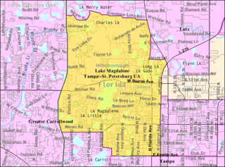
Lake Magdalene is a census-designated place (CDP) in Hillsborough County, Florida, United States. It is part of the Tampa Bay area. The population was 30,742 at the 2020 census.

<span class="mw-page-title-main">Country Club, Florida</span> Census-designated place in Florida

Country Club is a census-designated place and a suburban unincorporated community located in northwest Miami-Dade County, Florida, United States. It is located in the Miami metropolitan area of South Florida. The CDP is named after the Country Club of Miami, which was established in 1961 in what was then an unpopulated and undeveloped section of the county. The population was 49,967 at the 2020 census, up from 3,408 in 1990.

<span class="mw-page-title-main">Kendale Lakes, Florida</span> Census-designated place in Florida

Kendale Lakes is a census-designated place (CDP) and a suburb of Miami in Miami-Dade County, Florida, United States. It is located in the Miami metropolitan area of South Florida. The population was 55,646 at the 2020 census.

<span class="mw-page-title-main">Kendall West, Florida</span> Census-designated place in Florida

Kendall West is a census-designated place and unincorporated community in Miami-Dade County, Florida, west of the Florida Turnpike. It is located in the Miami metropolitan area of South Florida. The population was 36,536 at the 2020 census.

<span class="mw-page-title-main">Olympia Heights, Florida</span> Census-designated place in Florida

Olympia Heights is a census-designated place in Miami-Dade County, Florida, United States. It is located in the Miami metropolitan area of South Florida. The population was 12,873 at the 2020 census.

<span class="mw-page-title-main">Palm Springs North, Florida</span> Census-designated place in Florida

Palm Springs North is an unincorporated community and census-designated place (CDP) in Miami-Dade County, Florida, United States. It is part of the Miami metropolitan area of South Florida. The population was 5,030 at the 2020 census.

<span class="mw-page-title-main">Sunset, Florida</span> Census-designated place in Florida

Sunset is a census-designated place (CDP) in Miami-Dade County, Florida, United States. It is part of the Miami metropolitan area of South Florida. The population was 15,912 at the 2020 census. The U.S. Postal Service uses the ZIP Codes of 33173 and 33183 for Sunset.

<span class="mw-page-title-main">Tamiami, Florida</span> Census-designated place in Florida

Tamiami is a census-designated place (CDP) in Miami-Dade County, Florida, United States. It is part of the Miami metropolitan area of South Florida. The population was 54,212 at the 2020 census.

<span class="mw-page-title-main">The Crossings, Florida</span> CDP in Florida

The Crossings is a census-designated place (CDP) and suburb of Miami in Miami-Dade County, Florida, United States. It is part of the Miami metropolitan area of South Florida. The CDP includes the neighborhoods of The Crossings, Devon Aire, and Calusa. The population was 23,276 at the 2020 census.

<span class="mw-page-title-main">The Hammocks, Florida</span> Census-designated place in Florida

The Hammocks is a planned community and census-designated place in Miami-Dade County, Florida, United States. It is part of the Miami metropolitan area of South Florida. The population was 59,480 at the 2020 census, up from 51,003 in 2010.

<span class="mw-page-title-main">West Little River, Florida</span> CDP in Miami-Dade County, Florida, US

West Little River is a census-designated place (CDP) in Miami-Dade County, Florida, United States. It is part of the Miami metropolitan area of South Florida. The population was 34,128 at the 2020 census.

<span class="mw-page-title-main">Westwood Lakes, Florida</span> Census-designated place in Florida

Westwood Lakes is a census-designated place and unincorporated community of Miami-Dade County, Florida, United States. It is part of the Miami metropolitan area of South Florida. The population was 11,373 at the 2020 census.

<span class="mw-page-title-main">Wesley Chapel, Florida</span> CDP in Florida, United States

Wesley Chapel is a census-designated place in Pasco County, Florida, United States. Wesley Chapel is a suburb in the Tampa Bay Area.

<span class="mw-page-title-main">East Lake, Pinellas County, Florida</span> Census-designated place in Florida, United States

East Lake is a census-designated place (CDP) in Pinellas County, Florida, United States. The population was 30,962 at the 2010 census. It was one of the last areas in the densely populated county to develop. It is often confused with East Lake in neighboring Hillsborough County.

<span class="mw-page-title-main">Carrollwood (CDP), Florida</span> Census-designated place in Florida, United States

Carrollwood is a census-designated place (CDP) in northwestern Hillsborough County, Florida, United States. The census area includes the unincorporated communities of Carrollwood and Carrollwood Village. For the 2000 census the area was enumerated under the name "Greater Carrollwood". A similar area was listed as "Lake Carroll" in 1970 and 1980; for the 1990 census it was split into the smaller Carrollwood and Carrollwood Village CDPs. The population was 34,352 at the 2020 census.

Poinciana is a settlement and census-designated place (CDP) in Osceola and Polk counties in the U.S. state of Florida. It is part of the Greater Orlando area. As of the 2020 census, the CDP had a population of 69,309.

<span class="mw-page-title-main">Alafaya, Florida</span> Census-designated place in Florida, United States

Alafaya is a census-designated place and unincorporated area in Orange County, Florida, United States. The population was 92,452 at the 2020 US census. It is part of the Orlando–Kissimmee–Sanford, Florida Metropolitan Statistical Area. It is most known for being near the University of Central Florida, Avalon Park and Waterford Lakes.

References

  1. "2020 U.S. Gazetteer Files". United States Census Bureau. Retrieved October 31, 2021.
  2. "U.S. Census website". United States Census Bureau . Retrieved January 31, 2008.
  3. "US Board on Geographic Names". United States Geological Survey. October 25, 2007. Retrieved January 31, 2008.
  4. Bedard, Diane. "Developing Land O'Lakes". NatureCoaster. Retrieved June 19, 2023.
  5. Cannon, Jeff. "What's In A Name: Denham Oaks Elementary School" . Retrieved June 19, 2023.
  6. "CENSUS OF POPULATION AND HOUSING (1790-2000)". U.S. Census Bureau . Retrieved July 18, 2010.
  7. "P2 HISPANIC OR LATINO, AND NOT HISPANIC OR LATINO BY RACE - 2010: DEC Redistricting Data (PL 94-171) - Land O' Lakes CDP, Florida". United States Census Bureau .
  8. "P2 HISPANIC OR LATINO, AND NOT HISPANIC OR LATINO BY RACE - 2020: DEC Redistricting Data (PL 94-171) - Land O' Lakes CDP, Florida". United States Census Bureau .
  9. "S1101 HOUSEHOLDS AND FAMILIES - 2020: Land O' Lakes CDP, Florida". United States Census Bureau .
  10. "S1101 HOUSEHOLDS AND FAMILIES - 2010: Land O' Lakes CDP, Florida". United States Census Bureau .
  11. Sullivan, Erin. "A mayor, but not actually mayoral." St. Petersburg Times . November 2, 2006. Retrieved on March 19, 2014.