Lappwald

Last updated
Road in the Lappwald near Bad Helmstedt Lappwald Strasse.jpg
Road in the Lappwald near Bad Helmstedt

The Lappwald is a heavily wooded range of hills, 20 km long and up to 5 km wide, in central Germany. It stretches northwards from the town of Helmstedt. The border between Lower Saxony and Saxony-Anhalt runs through the woods, of which about three quarters is on Lower Saxon terrain. The Lappwald is part of the Elm-Lappwald Nature Park.

Helmstedt Place in Lower Saxony, Germany

Helmstedt is a town on the eastern edge of the German state of Lower Saxony. It is the capital of the District of Helmstedt. The historic university and Hanseatic city conserves an important monumental heritage of Romanesque and Renaissance buildings, as well as numerous timber framed houses. During the German partition the nearby Bundesautobahn 2 was the site of the Helmstedt–Marienborn border crossing, the most important on the former inner German border as starting point of the shortest land route between West Germany and West Berlin.

Lower Saxony State in Germany

Lower Saxony is a German state (Land) situated in northwestern Germany. It is the second-largest state by land area, with 47,624 km2 (18,388 sq mi), and fourth-largest in population among the 16 Länder federated as the Federal Republic of Germany. In rural areas, Northern Low Saxon and Saterland Frisian are still spoken, but the number of speakers is declining.

Saxony-Anhalt State in Germany

Saxony-Anhalt is a state of Germany.

Contents

Location

The 1st Walbecker Warte, a watchtower on the Helmstedt dyke (Landwehr) Walbecker Warte 1.jpg
The 1st Walbecker Warte, a watchtower on the Helmstedt dyke (Landwehr)
Magdeburg watchtower near Helmstedt Lappwald Wartturm.jpg
Magdeburg watchtower near Helmstedt
Watchtower on the former Inner German Border in the Lappwald Wachturm im Lappwald.JPG
Watchtower on the former Inner German Border in the Lappwald

The Lappwald runs from north-west to south-east parallel to the Elm hills, which lie about 10 km further west. The forests of the Lappwald are almost entirely uninhabited. The only settlements are the Helmstedt hamlet of Bad Helmstedt and the Harbke sector of Autobahn in the south, and the installations of the old airbase of Mariental in the north.

Harbke Place in Saxony-Anhalt, Germany

Harbke is a municipality in the Börde district in Saxony-Anhalt, Germany.

History

The first records describe the Lappwald as the Lapvualt in the year 1147. [1] There is no clear derivation for the name "Lappwald". The most likely theory is to do with the hunting term Einlappens. The Lappwald was a border forest for many centuries between the Brunswick and Prussian territories. Numerous smugglers and other criminals, including the well-known figure of "Robber Captain Rose" (Räuberhauptmann Rose, real name: Carl Wallmann) used the forest's border situation to their advantage. In the 20th century the Inner German Border divided the Lappwald, following the old Brunswick-Prussian boundary.

Hunting Searching, pursuing, catching and killing wild animals

Hunting is the practice of killing or trapping animals, or pursuing or tracking them with the intent of doing so. Hunting wildlife or feral animals is most commonly done by humans for food, recreation, to remove predators that can be dangerous to humans or domestic animals, or for trade. Lawful hunting is distinguished from poaching, which is the illegal killing, trapping or capture of the hunted species. The species that are hunted are referred to as game or prey and are usually mammals and birds.

In the Lappwald northeast of Helmstedt are the remains of a defensive ditch forming part of the old dyke to Walbeck. The structures that have survived include two watchtowers from the 13th century which are referred to as the 1st and 2nd Walbeck Watchtowers (Walbecker Warte). Another well-preserved medieval watchtower is located immediately next to the B 1 federal road to Magdeburg on the edge of the Lappwald.

Watchtower type of fortification

A watchtower is a type of fortification used in many parts of the world. It differs from a regular tower in that its primary use is military and from a turret in that it is usually a freestanding structure. Its main purpose is to provide a high, safe place from which a sentinel or guard may observe the surrounding area. In some cases, non-military towers, such as religious towers, may also be used as watchtowers.

Bundesstraße 1 federal highway in Germany

The Bundesstraße 1 is a German federal highway running in an east-west direction from the Dutch border near Aachen to the Polish border at Küstrin-Kietz on the Oder River.

Magdeburg Large city in Saxony-Anhalt, Germany

Magdeburg is the capital city and the second largest city of the state of Saxony-Anhalt, Germany. It is situated on the Elbe River.

Geology

From a geological point of view, the Lappwald, which reaches a height of 211 m on the Heidberg, is a hollow, that only appears like a raised horst due to the sharply downfaulted terrain it is surrounded by. In the Cretaceous, a period of some 71 million years, the sea washed chalk, marls and sands in several flood phases into the Helmstedt and Schöppenstedt hollow and thus covered the underlying rock. Further flooding by the sea in the succeeding Tertiary era created large areas of bog in the Helmstedt Basin that were transformed under sub-tropical climatic conditions into massive brown coal deposits.

Horst (geology) A raised fault block bounded by normal faults

In physical geography and geology, a horst is a raised fault block bounded by normal faults. A horst is a raised block of the Earth's crust that has lifted, or has remained stationary, while the land on either side (graben) has subsided. The word Horst in Dutch and German means heap – cognate with English "hurst".

The Cretaceous is a geologic period and system that spans 79 million years from the end of the Jurassic Period 145 million years ago (mya) to the beginning of the Paleogene Period 66 mya. It is the last period of the Mesozoic Era, and the longest period of the Phanerozoic Eon. The Cretaceous Period is usually abbreviated K, for its German translation Kreide.

Schöppenstedt Place in Lower Saxony, Germany

Schöppenstedt is a small town in the district of Wolfenbüttel, in Lower Saxony, Germany. It is the administrative seat of the Samtgemeinde of Elm-Asse.

Related Research Articles

Aller (Germany) Sidestream of the river Weser

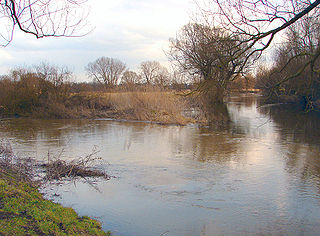
The Aller is a 215-kilometre (134 mi) long river in the states of Saxony-Anhalt and Lower Saxony in Germany. It is a right-hand, and hence eastern, tributary of the Weser and is also its largest tributary. Its last 117 kilometres (73 mi) form the Lower Aller federal waterway (Bundeswasserstraße). The Aller was extensively straightened, widened and, in places, dyked, during the 1960s to provide flood control of the river. In a 20-kilometre (12 mi) long section near Gifhorn, the river meanders in its natural river bed.

Gifhorn (district) District in Lower Saxony, Germany

Gifhorn is a district in Lower Saxony, Germany.

Oker Sidestream of the river Aller

The Oker is a river in Lower Saxony, Germany, that has historically formed an important political boundary. It is a left tributary of the River Aller, 128 kilometres (80 mi) in length and runs in a generally northerly direction.

Helmstedt (district) District in Lower Saxony, Germany

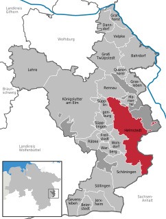
Helmstedt is a district in Lower Saxony, Germany. It is bounded by the district of Wolfenbüttel, the City of Braunschweig, the District of Gifhorn, the City of Wolfsburg and the State of Saxony-Anhalt.

Königslutter Place in Lower Saxony, Germany

Königslutter am Elm is a town in the district of Helmstedt in Lower Saxony, Germany.

Schunter river in Lower Saxony, Germany

Schunter is a river in Lower Saxony, Germany. It has a length of 58 km (36 mi) and is a right tributary of the Oker.

Elm (hills) mountain range

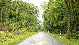
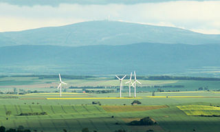
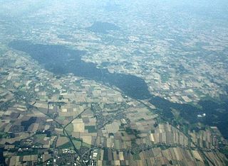
The Elm is a range of hills north of the Harz mountains in the Helmstedt and Wolfenbüttel districts of Lower Saxony, Germany. It has a length of about 25 km (15.5 mi) and a width of 3–8 km (2–5 mi) and rises to an elevation of 323 meters. Surrounded by the Northern European Lowlands, the Elm is almost uninhabited and the largest beech forest in Northern Germany. The hills are of a triassic limestone called Elmkalkstein. Together with the neighbouring Lappwald range, the Elm has been a protected nature park since 1977.

Helmstedt–Marienborn border crossing border checkpoint at the Inner German border

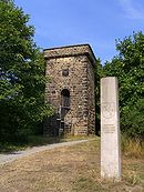
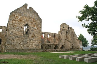
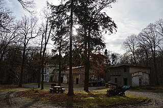
The Border checkpoint Helmstedt–Marienborn, named Grenzübergangsstelle Marienborn (GÜSt) by the German Democratic Republic (GDR), was the largest and most important border crossing on the Inner German border during the division of Germany. Due to its geographical location, allowing for the shortest land route between West Germany and West Berlin, most transit traffic to and from West Berlin used the Helmstedt-Marienborn crossing. Most travel routes from West Germany to East Germany and Poland also used this crossing. The border crossing existed from 1945 to 1990 and was situated near the East German village of Marienborn at the edge of the Lappwald. The crossing interrupted the Bundesautobahn 2 (A 2) between the junctions Helmstedt-Ost and Ostingersleben.

Walbeck, Börde Stadtteil of Oebisfelde-Weferlingen in Saxony-Anhalt, Germany

Walbeck is a village and a former municipality in the Börde district in Saxony-Anhalt, Germany. Since 1 January 2010, it is part of the town Oebisfelde-Weferlingen.

Derlingau

The Derlingau was an early medieval county (Gau) of the Duchy of Saxony.

Hohes Holz

The Hohes Holz is an extended forest area on the western rim of the otherwise open, agriculturally intensively-farmed Magdeburg Börde region in the German state of Saxony-Anhalt.

Drömling landscape in Lower Saxony and Saxony-Anhalt, Germany

The Drömling is a sparsely populated depression on the border of Lower Saxony and Saxony-Anhalt in Germany with an area of about 340 square kilometres (130 sq mi). The larger part belonging to Saxony-Anhalt in the east has been a nature park since 1990. The former swampland was transformed by drainage from a natural into a cultural landscape in the 18th century under the direction of Frederick the Great of Prussia. Today the depression, with its waterways, the Mittelland Canal and the rivers Aller and Ohre is a refuge for rare or endangered species of animal and plant. Most of the area is now made up of nature reserves and protected areas. Nearby towns include Oebisfelde and Wolfsburg.

Brunswick Land landscape

Brunswick Land is a historical region in the Southeast of the German state of Lower Saxony, centred around the city of Braunschweig. It refers to the core territory of the historic Duchy of Brunswick and its successor, the Free State of Brunswick, which was disestablished in 1946.

Elm-Lappwald Nature Park nature park in Lower Saxony, Germany

The Elm-Lappwald Nature Park is a nature park in southwest Lower Saxony, east of Brunswick in central Germany. It is dominated by the forested hill ranges of the Elm, Lappwald and Dorm as well as the region known as the Helmstedt Bowl.

Brunswick–Magdeburg railway railway line

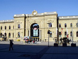
The Brunswick–Magdeburg railway is an 83-kilometre-long (52 mi) German main line railway. It is with the Berlin–Lehrte railway and the Hanover–Berlin high-speed line one of the most important east-west lines between Hanover and Berlin. Important intermediate stations are Königslutter, Helmstedt and Eilsleben.

Jerxheim–Helmstedt railway railway line

The Jerxheim–Helmstedt railway is a 22 km-long railway line in the south-east of the German state of Lower Saxony that was opened in 1858. It opened up the area south of the Elm hills. Until 8 December 2007, there were passenger services on the route from Brunswick via Wolfenbüttel, Schöppenstedt, Jerxheim and Schöningen to Helmstedt, which was last marketed as the Südelmbahn. The section from Helmstedt to Alversdorf freight yard has since been operated as a connecting line to a facility of the Energy from Waste (EEW) company, formerly half owned by E.ON.

Schaumburg Forest forest

The Schaumburg Forest is a wooded region, about 80 m above sea level (NN) with an area of around 40 km², in the district of Schaumburg in the German federal state of Lower Saxony.

References

  1. Hans-Ehrhard Müller: Helmstedt - die Geschichte einer deutschen Stadt, 2. Aufl. 2004, S. 184

Coordinates: 52°15′21.52″N11°02′23.30″E / 52.2559778°N 11.0398056°E / 52.2559778; 11.0398056