External links
| | This article relating to the history of the United States is a stub. You can help Wikipedia by expanding it. |
| Formation | 1919 |
|---|---|
| Founder | Governor Simon Bamberger |
The League of the Southwest was a 1919 alliance formed among U.S. states in the basin of the Colorado River with the intention of promoting development, in particular irrigation of cropland for agriculture, along the river. In 1921, two years later, the United States Congress authorized the states to negotiate an agreement for allocation of the river water, leading to the 1922 Colorado River Compact.
The League of the Southwest, the brainchild of San Diego promoter Arnold Kruckman, launched its developmental program for the Southwestern states with a gala convention at the Hotel del Coronado in San Diego in November, 1917. The fourth meeting (Denver) of the League, now a single-issue organization dedicated to the development of the Colorado River, was the occasion for Colorado lawyer Delph Carpenter's proposal that the Colorado River states create a compact or interstate treaty under Article I Section 10 of the U.S. Constitution
| | This article relating to the history of the United States is a stub. You can help Wikipedia by expanding it. |

The Rio Grande in the United States or the Río Bravo in Mexico, also known as P’osoge in Tewa and Tó Ba’áadi in Navajo, is one of the principal rivers in the southwestern United States and in northern Mexico. The length of the Rio Grande is 1,896 miles (3,051 km), making it the 4th longest river in the United States and in North America by main stem. It originates in south-central Colorado, in the United States, and flows to the Gulf of Mexico. The Rio Grande drainage basin (watershed) has an area of 182,200 square miles (472,000 km2); however, the endorheic basins that are adjacent to and within the greater drainage basin of the Rio Grande increase the total drainage-basin area to 336,000 square miles (870,000 km2).

The Southwestern United States, also known as the American Southwest or simply the Southwest, is a geographic and cultural region of the United States that includes Arizona and New Mexico, along with adjacent portions of California, Colorado, Nevada, Oklahoma, Texas, and Utah. The largest cities by metropolitan area are Phoenix, Las Vegas, El Paso, Albuquerque, and Tucson. Before 1848, in the historical region of Santa Fe de Nuevo México as well as parts of Alta California and Coahuila y Tejas, settlement was almost non-existent outside of Nuevo México's Pueblos and Spanish or Mexican municipalities. Much of the area had been a part of New Spain and Mexico until the United States acquired the area through the Treaty of Guadalupe Hidalgo in 1848 and the smaller Gadsden Purchase in 1854.
The Western United States, also called the American West, the Western States, the Far West, and the West, is the region comprising the westernmost U.S. states. As American settlement in the U.S. expanded westward, the meaning of the term the West changed. Before around 1800, the crest of the Appalachian Mountains was seen as the western frontier. The frontier moved westward and eventually the lands west of the Mississippi River were considered the West.

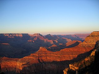
The Colorado River is one of the principal rivers in the Southwestern United States and in northern Mexico. The 1,450-mile-long (2,330 km) river, the 5th longest in the United States, drains an expansive, arid watershed that encompasses parts of seven U.S. states and two Mexican states. The name Colorado derives from the Spanish language for "colored reddish" due to its heavy silt load. Starting in the central Rocky Mountains of Colorado, it flows generally southwest across the Colorado Plateau and through the Grand Canyon before reaching Lake Mead on the Arizona–Nevada border, where it turns south toward the international border. After entering Mexico, the Colorado approaches the mostly dry Colorado River Delta at the tip of the Gulf of California between Baja California and Sonora.

The Arkansas River is a major tributary of the Mississippi River. It generally flows to the east and southeast as it traverses the U.S. states of Colorado, Kansas, Oklahoma, and Arkansas. The river's source basin lies in Colorado, specifically the Arkansas River Valley. The headwaters derive from the snowpack in the Sawatch and Mosquito mountain ranges. It flows east into Kansas and finally through Oklahoma and Arkansas, where it meets the Mississippi River.

The San Juan River is a major tributary of the Colorado River in the Southwestern United States, providing the chief drainage for the Four Corners region of Colorado, New Mexico, Utah, and Arizona. Originating as snowmelt in the San Juan Mountains of Colorado, it flows 383 miles (616 km) through the deserts of northern New Mexico and southeastern Utah to join the Colorado River at Glen Canyon.

The Colorado River Aqueduct, or CRA, is a 242 mi (389 km) water conveyance in Southern California in the United States, operated by the Metropolitan Water District of Southern California (MWD). The aqueduct impounds water from the Colorado River at Lake Havasu on the California-Arizona border, west across the Mojave and Colorado deserts to the east side of the Santa Ana Mountains. It is one of the primary sources of drinking water for Southern California.
The Colorado River dispute is a long-running dispute between the United States and Mexico over water rights to the Colorado River.

San Diego Flash was an American soccer team based in San Diego, California, United States. Founded in 1998, the team returned to competitive play in 2011 and most recently played in the Southern Conference of the West Division of the National Premier Soccer League (NPSL), the fourth tier of the American Soccer Pyramid. For the 2001 season the team was known as San Diego F.C..

The Colorado River Compact is a 1922 agreement that regulates water distribution among seven states in the southwestern United States. The contract is about the area within the drainage basin of the Colorado River.
Parker Dam is a concrete arch-gravity dam that crosses the Colorado River 155 miles (249 km) downstream of Hoover Dam. Built between 1934 and 1938 by the Bureau of Reclamation, it is 320 feet (98 m) high, 235 feet (72 m) of which are below the riverbed (the deep excavation was necessary in order to reach the bedrock on which the foundation of the dam was built), making it the deepest dam in the world. The portion of the dam above the foundation stands 85 feet (25.9 m) tall, making it the only dam in the world that stands more underground than above ground. The dam's primary functions are to create a reservoir, and to generate hydroelectric power. The reservoir behind the dam is called Lake Havasu and can store 647,000 acre⋅ft (798,000,000 m3; 2.11×10¹¹ US gal; 1.76×10¹¹ imp gal). The dam straddles the Arizona-California state border at the narrows the river passes through between the Whipple Mountains in San Bernardino County, California and the Buckskin Mountains in La Paz County, Arizona.

The Colorado River Storage Project is a United States Bureau of Reclamation project designed to oversee the development of the upper basin of the Colorado River. The project provides hydroelectric power, flood control and water storage for participating states along the upper portion of the Colorado River and its major tributaries.
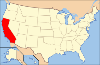
The environment of California describes results of human habitation of the American State of California.
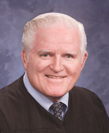
Thomas John Whelan is a senior United States district judge of the United States District Court for the Southern District of California.
In the history of the American frontier, pioneers built overland trails throughout the 19th century, especially between 1840 and 1847 as an alternative to sea and railroad transport. These immigrants began to settle much of North America west of the Great Plains as part of the mass overland migrations of the mid-19th century. Settlers emigrating from the eastern United States did so with various motives, among them religious persecution and economic incentives, to move from their homes to destinations further west via routes such as the Oregon, California, and Mormon Trails. After the end of the Mexican–American War in 1849, vast new American conquests again encouraged mass immigration. Legislation like the Donation Land Claim Act and significant events like the California Gold Rush further encouraged settlers to travel overland to the west.

Southern Emigrant Trail, also known as the Gila Trail, the Kearny Trail, Southern Trail and the Butterfield Stage Trail, was a major land route for immigration into California from the eastern United States that followed the Santa Fe Trail to New Mexico during the California Gold Rush. Unlike the more northern routes, pioneer wagons could travel year round, mountain passes not being blocked by snows; however, it had the disadvantage of summer heat and lack of water in the desert regions through which it passed in New Mexico Territory and the Colorado Desert of California. Subsequently, it was a route of travel and commerce between the eastern United States and California. Many herds of cattle and sheep were driven along this route and it was followed by the San Antonio-San Diego Mail Line in 1857–1858 and then the Butterfield Overland Mail from 1858 to 1861.

Water in Colorado is of significant importance, as the American state of Colorado is the 7th-driest state in America. As result, water rights generate conflict, with many water lawyers in the state.

The San Juan–Chama Project is a U.S. Bureau of Reclamation interbasin water transfer project located in the states of New Mexico and Colorado in the United States. The project consists of a series of tunnels and diversions that take water from the drainage basin of the San Juan River – a tributary of the Colorado River – to supplement water resources in the Rio Grande watershed. The project furnishes water for irrigation and municipal water supply to cities along the Rio Grande including Albuquerque and Santa Fe.
The 2014 Lamar Hunt U.S. Open Cup tournament proper features teams from all five tiers of men's soccer of the American Soccer Pyramid.