This is a list of the buildings, sites, districts, and objects listed on the National Register of Historic Places in the Northern Mariana Islands. There currently 37 listed sites spread across the four municipalities of the Northern Mariana Islands. There are no sites listed on any of the islands that make up the Northern Islands Municipality.
Dinay is a village belonging to the municipality of Rull in the southern part of the island of Yap in the Federated States of Micronesia. The village was added to the United States National Register of Historic Places in 2004. It is unique in Micronesia as the site of an ancient pottery complex, and is probably one of the earliest settlements on the island. The ancient village complex includes more than a dozen family platforms (daf) of such age that local folklore has forgotten their lineages, normally a significant cultural feature of such sites. The period of occupation is estimated to have been between about 3000 BCE and 1600 CE.

Xavier High School is a Jesuit coeducational high school located on the island of Weno in Chuuk, Federated States of Micronesia. It was established in 1952. It was the first high school in the Trust Territory of the Pacific Islands. Bishop Thomas Feeney, S.J., D.D. from the New York Province of the Society of Jesus originally envisioned a minor seminary to train local clergy. Soon after, Xavier Seminary became the first college preparatory school in the Western Pacific.
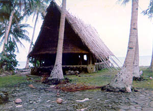
The Rull Men's Meetinghouse is a historic meeting house in Rull, a village on the island of Yap in the Federated States of Micronesia. It is a large rectangular structure, set on a raised stone platform. The flooring consists of treated betelnut palm trunks, and has a steeply pitched roof made of bamboo supports with various types of tropical leaves tied in place using coconut fiber. The faluw, although not the first built on this platform, has historically occupied a central place in the civic life of the community, serving as a place where the men of the village could meet in seclusion, and as a place for social rites.
The Wiichen Men's Meetinghouse is a historic building site in Peniesene on Moen Island in Chuuk State of the Federated States of Micronesia. The site, deemed archaeologically significant due to its place in Chuukese folklore, includes a pre-contact period petroglyph panel and swimming basin. Local history claims that this was the meeting place of six brothers who became the first chieftains of Chuuk.
The Japanese Lighthouse, or Poluwat Lighthouse, is an abandoned lighthouse situated on Alet Island in Poluwat, Chuuk in the Federated States of Micronesia. It was completed in 1940 by the Japanese and was in use until being attacked by U.S. forces in World War II. It was listed on the National Register of Historic Places in 1983. The lighthouse is a good example of pre-World War II "marine architecture" built by the Japanese.
Safonfok is a prehistoric archaeological site near Walung, on the island of Kosrae in the Federated States of Micronesia. At the time of its discovery in 1999, it was one of the largest prehistoric industrial complex found in the islands of the Pacific. The site, whose extent has not been fully determined, was excavated in 1999-2000, revealing a major complex where an estimated hundreds of workers manufactured coral fish hooks and other tools. Unique among the finds are a basalt knife and a diamond-shaped bead.
The Chief Agriculturist House is a historic house in Kolonia, the capital of Pohnpei State in the Federated States of Micronesia. It is a steel and concrete structure, built in the mid-1920s when Pohnpei and the other Caroline Islands were part of the Japanese South Pacific Mandate. It was one of the highest-quality buildings constructed on Pohnpei during the Japanese administration, and was the home of the Japanese weatherman and agricultural overseer, said to be the second most powerful figure in Japanese Micronesia.
The World War II Japanese Army Headquarters for the defense of Tonowas, an island in what is now Chuuk State in the Federated States of Micronesia, was located in an underground bunker in the village of Roro. The underground facilities, including an office, communications center, print shop, supply room, and health clinic, were built in response to American air raids against the facilities, which were associated with the major naval facility of the Imperial Japanese Navy in Chuuk Lagoon.

Tarang, also known as O'Keefe's Island is a small island in the main harbor of Yap Island in the Federated States of Micronesia. It is located roughly in the center of the harbor east of Colonia, the Yapese capital, between Pekel and Bi Islands. It is a low island with a maximum height of about 22 feet (6.7 m), and is overgrown with tropical vegetation. The island has local historical importance as the home of Captain David O'Keefe, an enterprising American who arrived on Yap in the 1870s, and was responsible for not only significant economic growth, but also for the depreciation of the distinctive Yapese currency, the large rai stones which became devalued after O'Keefe introduced iron tools that made manufacture of the stones easier. O'Keefe settled on Tarang, where he had a boat landing, coal warehouse, and house. Of these structures, only the boat landing has survived; only foundations survive of the others.
The German Cemetery is a historic cemetery in Kolonia, the capital of Pohnpei State in the Federated States of Micronesia. Pohnpei and the other Caroline Islands had become a German protectorate in 1899, after the Spanish–American War, and were administered as part of German New Guinea. This cemetery is a historical reminder of the period of German administration, although it was in deteriorated condition in 1976, accessible only by hiking through a mangrove swamp, with its wrought iron fence and gate in disrepair. Two German governors were buried here.

Tonnachau Mountain, is a mountain on Moen Island in Chuuk State of the Federated States of Micronesia. Rising to a height of 1,100 feet (340 m), it is not the highest peak of Moen, which is Mount Teroken to the south. Tonnachau is, however, a prominent landmark rising above Chuuk International Airport. The mountain also has an important place in Chuukese culture and prehistory, with archaeologically significant prehistoric middens and fortifications on its summit ridge which date back as far as 4,000 BCE. Chuukese tradition states that its hero Soukachou built a fort on Tonachau when he arrived from Kosrae and established rule over the lagoon. The mountain also has extensive remains of mainly Japanese fortifications erected during World War II.
The Spanish Fort in Colonia, the capital of Yap State in the Federated States of Micronesia, is a historic seat of power on the island of Yap. Only foundational remnants of the 19th-century Spanish fortification survive, on a property now occupied by the local government. The site was also where German and Japanese administrators had their headquarters during their respective periods of administration in the decades of the 20th century before World War II. The foundation was built of stone and cement, and is still accessible via its original steps.
The Japanese Hydro-electric Power Plant is a former hydroelectric power generation plant and historic site in Kolonia, the capital of Pohnpei State in the Federated States of Micronesia. The site is historically and culturally important as a representative of three different eras in the island's history. The site is important in the culture of Pohnpei as a location of high-quality stones gathered for use in ritual ceremonies involving the pounding of kava and drinking preparations from the plant. In the early 1900s, when Pohnpei was administered as part of German New Guinea, the German administration established an experimental forest, planting a diversity of trees from around the world, some of which continue to thrive in the area. Finally, in the 1920s, during the Japanese South Pacific Mandate, a hydroelectrict facility was built here. When the property was listed on the United States National Register of Historic Places in 1976 the concrete power plant building and water catchment basin survived.
The Tonotan Guns and Caves are a series of World War II-era military fortification on the island of Weno, the main island of Chuuk State in the Federated States of Micronesia. They consist of an excavation housing an English naval gun, and a series of caves used for housing and operations that provided shelter from aerial bombardment. The installations are located on the lower north flank of Mount Teroken, the island's highest peak.
The Fauba Archaeological Site is a prehistoric stoneworks on a mountain ridge on Tol Island in Chuuk State of the Federated States of Micronesia. The site consists of an area enclosed by a stone wall that is roughly triangular in shape. The wall is between 1 and 1.5 meters in height, and is about 1 meter thick. The enclosed area includes a number of stone platforms, and there is a refuse midden outside the enclosure that is believed to be associated with the site. The exact purpose of the site is a subject of debate: although its siting has obvious military benefits (including commanding views of Chuuk Lagoon and other islands of the atoll, it is not clear that it actually saw military activity.
The Japanese Artillery Road and Pohndolap Area are a historic area on Sokehs Island in the Federated States of Micronesia. Sokehs has a prominent north-south ridge (known locally as "Pohndolap", overlooking the state capital Kolonia, and was fortified by the Japanese during World War II. They built a road to the summit area and emplaced anti-aircraft guns on the ridge. The ridge was also a key site in the 1910 Sokehs Rebellion against Japanese rule, and the remnants of a Pohnpeian fort are also in the area. The surviving elements of these fortifications were listed on the United States National Register of Historic Places in 1976. The old road is now part of a hiking trail, leading up to the fortifications.
The Sokehs Mass Grave Site is the location where fifteen participants of the 1910/1911 Sokehs Rebellion on the island of Pohnpei were buried by German colonial authorities. The rebellion broke out in October 1910 on Sokehs Island and was suppressed by German naval forces by early 1911. At a summary trial of 36 Sokehs rebels, 17 were convicted of murder and insurrection, and 15 subsequently executed by firing squad and buried in this mass grave. All members of the Sokehs tribe were then exiled to Babelthuap. The mass grave site is a roughly square area 16 feet (4.9 m) on each side, surrounded by a low stone wall. The site is now identified by a memorial marker.