In Celtic mythology, Clota was the patron goddess of the River Clyde. Perhaps worshiped by the local Welsh-speaking Damnonii tribe who held the territory which later was to become the Kingdom of Strathclyde. The Damnonii allied themselves with Rome who recorded and mapped the Clota estuary. During the Antonine period the Romans built the Antonine Wall from the Forth to the Clyde and created a causeway stretching across the 'Clota' which linked the forts at Bishopton, Greenock and Largs, to the Antonine Wall.

Lilies of the Field is a 1963 American comedy drama film adapted by James Poe from the 1962 novel of the same name by William Edmund Barrett, and stars Sidney Poitier, Lilia Skala, Stanley Adams, and Dan Frazer. It was produced and directed by Ralph Nelson. The title comes from the Sermon on the Mount in the Bible. It features an early film score by prolific composer Jerry Goldsmith. The film was turned into a Broadway musical in 1970, retitled Look to the Lilies, with Shirley Booth in the role of Mother Maria Marthe.
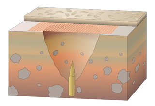
In medieval fortification, a trou de loup was a type of booby trap or defensive obstacle. Each trou de loup consisted of a conical pit about 2 m deep and 1.2 to 2 m wide at the top. At the bottom of the pit, a sharpened punji stick would be hammered in. In some cases, the pit was concealed by light cover of wicker and a layer of soil.

Lilia Skala was an Austrian-American architect and actress known for her role in the film Lilies of the Field (1963), for which she received critical acclaim and an Academy Award nomination. During her career, Skala was also nominated for two Golden Globe Awards and a Primetime Emmy Award.

Summerston is a residential area of Glasgow, Scotland. With most of the housing constructed in the 1970s, it is situated in the far north of the city and is considered to be part of the larger Maryhill district, but has a different postcode; other nearby neighbourhoods are Gilshochill to the south and Cadder to the south-east. With open farmland to the north-east, Summerston is separated from the southern parts of the town of Bearsden to the north-west by the River Kelvin and a golf course.
Croy is a village in North Lanarkshire, Scotland. A former mining community, Croy is situated south of Kilsyth and north of Cumbernauld, some 13 miles (21 km) from Glasgow and 37 miles (60 km) from Edinburgh on the main railway line between the two cities. Croy has a population of about 1,390.

Rough Castle Fort is a Roman fort on the Antonine Wall roughly 2 kilometres south east of Bonnybridge near Tamfourhill in the Falkirk council area, Scotland. It is owned by the National Trust for Scotland.

Westerwood is an area in the north-east of Cumbernauld in North Lanarkshire, Scotland. Historically it was the site of a Roman Fort of which a video reconstruction has been produced. In the past two decades, new housing developments have been built around the Westerwood Hotel and Golf Course. The golf course, which was designed by Seve Ballesteros and Dave Thomas, is located on the north side of the town, close to Cumbernauld Airport. Westerwood Community Council was set up for local residents and a committee has been appointed. Neighbouring villages which are outside of Cumbernauld include Dullatur to the north-west and Castlecary to the east.

Isabella Lilias Trotter was a British artist and a Protestant missionary to Algeria.

Defensive walls are a feature of ancient Roman architecture. The Romans generally fortified cities, rather than building stand-alone fortresses, but there are some fortified camps, such as the Saxon Shore forts like Porchester Castle in England. City walls were already significant in Etruscan architecture, and in the struggle for control of Italy under the early Republic many more were built, using different techniques. These included tightly-fitting massive irregular polygonal blocks, shaped to fit exactly in a way reminiscent of later Inca work. The Romans called a simple rampart wall an agger; at this date great height was not necessary. The Servian Wall around Rome was an ambitious project of the early 4th century BC. The wall was up to 10 metres (32.8 ft) in height in places, 3.6 metres (12 ft) wide at its base, 11 km (7 mi) long, and is believed to have had 16 main gates, though many of these are mentioned only from writings, with no other known remains. Some of it had a fossa or ditch in front, and an agger behind, and it was enough to deter Hannibal. Later the Aurelian Wall replaced it, enclosing an expanded city, and using more sophisticated designs, with small forts at intervals.

The Antonine Wall, known to the Romans as Vallum Antonini, was a turf fortification on stone foundations, built by the Romans across what is now the Central Belt of Scotland, between the Firth of Clyde and the Firth of Forth. Built some twenty years after Hadrian's Wall to the south, and intended to supersede it, while it was garrisoned it was the northernmost frontier barrier of the Roman Empire. It spanned approximately 63 kilometres and was about 3 metres high and 5 metres wide. Lidar scans have been carried out to establish the length of the wall and the Roman distance units used. Security was bolstered by a deep ditch on the northern side. It is thought that there was a wooden palisade on top of the turf. The barrier was the second of two "great walls" created by the Romans in Great Britain in the second century AD. Its ruins are less evident than those of the better-known and longer Hadrian's Wall to the south, primarily because the turf and wood wall has largely weathered away, unlike its stone-built southern predecessor.
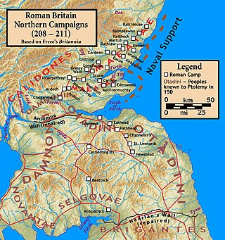
The Roman invasion of Caledonia was launched in 208 by the Roman emperor Septimius Severus. The invasion lasted until late 210, when the emperor became ill and died at Eboracum (York) on 4 February 211. The war started well for the Romans with Severus managing to quickly reach the Antonine Wall, but when Severus pushed north into the highlands he became bogged down in a guerrilla war and he was never able to fully subjugate Caledonia. He reoccupied many forts built by Agricola over 100 years earlier, following the Battle of Mons Graupius, and crippled the ability of the Caledonians to raid Roman Britain.

The architecture of Scotland in the Roman era includes all building within the modern borders of Scotland, from the arrival of the Romans in northern Britain in the first century BCE, until their departure in the fifth century CE. Ptolemy indicated that there were 19 "towns" in Caledonia, north of the Roman province of Britannia, but no clear evidence of urban settlements has been found and these were probably hillforts. There is evidence of over 1,000 such forts, most south of the Clyde-Forth line, but the majority seem to have been abandoned in the Roman period. There is also evidence of distinctive stone wheelhouses and small underground souterrains.

The Clydesdale Bank £50 note was a sterling banknote. Until its withdrawal it was the second largest denomination of banknote issued by the Clydesdale Bank. The last cotton note, first issued in 2009 bears a portrait of Elsie Inglis, founder of the Scottish Women's Hospitals, on the obverse and an image of the Antonine Wall on the reverse.

Bar Hill Fort was a Roman fort on the Antonine Wall in Scotland. It was built around the year 142 A.D.. Older maps and documents sometimes spell the name as Barr Hill. A computer generated fly around for the site has been produced. Lidar scans have been done along the length of the wall including Bar Hill. Sir George Macdonald wrote about the excavation of the site. Many other artefacts have also been found at Shirva, about a mile away on the other side of Twechar.
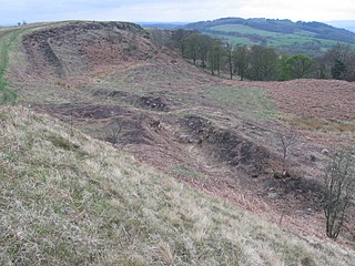
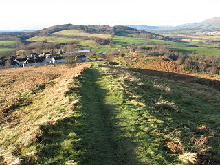
Croy Hill was a Roman fort, fortlet, and probable temporary camp on the Antonine Wall, near Croy, to the north east of the village in Scotland. Two communication platforms known as ‘expansions’ can be seen to the west of the fortlet. Alexander Park excavated the site in 1890-1891. Sir George Macdonald wrote about his excavation of the site which occurred in 1920, 1931, and 1935. At Croy Hill, the ditch in front of the rampart was not excavated by the Romans. It is likely that hard basalt and dolerite of the hill was virtually impossible to shape with Roman tools. This is the only place along the Wall where the ditch wasn't dug. There is a bath house just outside one fort. A video reconstruction of the site has been produced.

Watling Lodge was a Roman fortlet on the Antonine Wall in Scotland. It was located near what is now Lock Sixteen on the Forth and Clyde Canal in Falkirk with neighbouring forts at Rough Castle to the west and Falkirk to the east. There was also a fort at Camelon to the north. There was also a Roman temporary camp found a short distance south of the site.

Mumrills was the site of the largest Roman fort on the Antonine Wall in Scotland. It is possible that Mumrills could exchange signals with Flavian Gask Ridge forts. Some believe Mumrills may have been the site of Wallace's defeat at the Battle of Falkirk. The farm at Mumrills was also used as an early site for the Falkirk Relief Church.

Inveravon is sited on the east side of the River Avon in Scotland. It was long considered to be the likely site for a Roman Fort on the Antonine Wall in Scotland. The fort is one of the most dubious on the wall although some excavation and geophysics has been done. Near Inveravon Tower, the bare traces of a fort were found but there is nothing that an unskilled visitor could identify. Several excavations have unearthed the site's foundations as well as a section of the Military Way. Cobbled surfaces and some stone walls were found. Also ‘expansions’ were discovered, perhaps used as signal or beacon towers.

Seabegs Wood was the site of a Roman fortlet on the Antonine Wall in Scotland.
