
The Shenandoah Valley is a geographic valley and cultural region of western Virginia and the Eastern Panhandle of West Virginia in the United States. The valley is bounded to the east by the Blue Ridge Mountains, to the west by the eastern front of the Ridge-and-Valley Appalachians, to the north by the Potomac River and to the south by the James River. The cultural region covers a larger area that includes all of the valley plus the Virginia highlands to the west, and the Roanoke Valley to the south. It is physiographically located within the Ridge and Valley province and is a portion of the Great Appalachian Valley.

The Shenandoah River is a tributary of the Potomac River, 55.6 miles (89.5 km) long with two forks approximately 100 miles (160 km) long each, in the U.S. states of Virginia and West Virginia. The principal tributary of the Potomac, the river and its tributaries drain the central and lower Shenandoah Valley and the Page Valley in the Appalachians on the west side of the Blue Ridge Mountains, in northwestern Virginia and the Eastern Panhandle of West Virginia.
U.S. Route 340 is a part of the U.S. Highway System that runs from Greenville, Virginia to Frederick, Maryland. In Virginia, it runs north–south, parallel and east of U.S. Route 11, from US 11 north of Greenville via Waynesboro, Grottoes, Elkton, Luray, Front Royal, and Berryville to the West Virginia state line. A short separate piece crosses northern Loudoun County on its way from West Virginia to Maryland.
Lunice Creek is a 7.3-mile-long (11.7 km) tributary of the South Branch Potomac River, belonging to the Potomac River and Chesapeake Bay watersheds. The creek is located in Grant County, West Virginia. Lunice Creek is created by its North and South Forks and empties into the South Branch at Petersburg.
The Moormans River is a 14.3-mile-long (23.0 km) tributary of the South Fork of the Rivanna River in central Virginia in the United States. Via the Rivanna and James rivers, it is part of the watershed of Chesapeake Bay.

The South River is one of the two main tributaries of the South Fork of the Shenandoah River. It begins south of Waynesboro, Virginia, and flows northward to Port Republic, where it merges with the North River to form the South Fork. The river is 52.6 miles (84.7 km) long.

The North River is a 55.3-mile-long (89.0 km) river in the mountains and Shenandoah Valley of northern Virginia, the United States. It joins the South River at Port Republic to form the South Fork Shenandoah River.

Reddish Knob of Shenandoah Mountain is one of the highest points in Virginia, rising 4,397 feet (1,340 m). A narrow, paved road reaches the summit from Harrisonburg, Virginia.
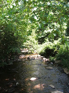
Smith Creek is a 35.5-mile-long (57.1 km) tributary stream of the North Fork of the Shenandoah River in the Shenandoah Valley of Virginia. Its watershed comprises 106 square miles (270 km2) within Shenandoah and Rockingham counties on the western slope of the Massanutten Mountain ridge. Its headwaters lie in Rockingham County just north of Harrisonburg, and its confluence with the North Fork of the Shenandoah River is located just south of Mount Jackson.
The German River is the principal tributary of the North Fork of the Shenandoah River, flowing for 14.7 miles (23.7 km) in the U.S. state of Virginia. The river originates in northern Rockingham County, just east of the West Virginia border, in the George Washington National Forest, near the crest of Shenandoah Mountain in the Allegheny Mountains.
The Thornton River is a 27.9-mile-long (44.9 km) river in the U.S. state of Virginia. It rises at Thornton Gap in Shenandoah National Park and flows east through Rappahannock County, running parallel to U.S. Route 211 until it reaches the town of Sperryville. Continuing east into Culpeper County, the Thornton River joins the Hazel River, a tributary of the Rappahannock River, and thus part of the Chesapeake Bay watershed.
The Cold Spring River is a 3.9-mile-long (6.3 km) mountain stream in Rockingham County in the U.S. state of Virginia. It is a tributary of the German River, the principal source of the North Fork Shenandoah River. Via the Shenandoah River, the Cold Spring River is part of the Potomac River watershed.
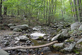
The Dry River is a 22.6-mile-long (36.4 km) tributary of the North River in the U.S. state of Virginia. It flows entirely within Rockingham County, rising within the George Washington National Forest east of the West Virginia border and flowing south to the North River at Bridgewater. Via the North River, it is part of the Shenandoah River system, flowing to the Potomac River.
The Hughes River is a 14.0-mile-long (22.5 km) river in Madison, Rappahannock, and Culpeper counties in the U.S. state of Virginia. The river rises on the east slope of Stony Man mountain in Shenandoah National Park and flows southeast past the village of Nethers to join the Hazel River west of Boston, Virginia. Via the Hazel River and the Rappahannock River, the Hughes River is part of the Chesapeake Bay watershed.
Two streams named Little River flow to the North River, a tributary of the South Fork Shenandoah River in the U.S. state of Virginia. Both rivers flow within the George Washington National Forest.
The Lynch River is a 9.8-mile-long (15.8 km) tributary of the North Fork Rivanna River in the U.S. state of Virginia. It is part of the James River watershed. It rises at the unincorporated community of Mission Home near the boundary of Shenandoah National Park and flows southeast past Shady Grove and Nortonsville to join the Roach River, forming the North Fork of the Rivanna at their confluence. The Lynch River flows through Greene and Albemarle counties, crossing their boundary several times.
The Middle River is a 70.6-mile-long (113.6 km) river in the U.S. state of Virginia. Flowing entirely within Augusta County, the Middle River joins the North River, which in turn meets the South River at Port Republic to form the South Fork Shenandoah River.
The Roach River is an 11.0-mile-long (17.7 km) tributary of the North Fork Rivanna River in the U.S. state of Virginia. It is part of the James River watershed.
The Staunton River is a 4.1-mile-long (6.6 km) stream in the U.S. state of Virginia. Flowing entirely within Shenandoah National Park, it is a tributary of the Rapidan River and part of the Rappahannock River watershed.

The Laurel Fork is a 15.7-mile-long (25.3 km) stream in Virginia and West Virginia, United States. The stream flows north from Highland County, Virginia, where its source and the majority of its length is located, to its mouth in Pendleton County, West Virginia. Laurel Fork is a tributary to the North Fork South Branch Potomac River, making it a part of the Potomac River watershed. The area surrounding Laurel Fork is home to several plant and animal species found nowhere else in Virginia, and is a prime example of a northern boreal forest in the state.


