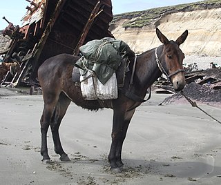
A mule is the offspring of a male donkey (jack) and a female horse (mare). Horses and donkeys are different species, with different numbers of chromosomes. Of the two first generation hybrids between these two species, a mule is easier to obtain than a hinny, which is the offspring of a female donkey (jenny) and a male horse (stallion).
Mount Elbert is the highest summit of the Rocky Mountains of North America and the highest point in the U.S. state of Colorado and the entire Mississippi River drainage basin. The ultra-prominent 14,440-foot (4401.2 m) fourteener is the highest peak in the Sawatch Range and the second-highest summit in the contiguous United States after Mount Whitney. Mount Elbert is located in San Isabel National Forest, 12.1 miles (19.4 km) southwest of the City of Leadville in Lake County, Colorado.
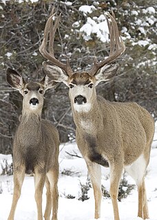
The mule deer is a deer indigenous to western North America; it is named for its ears, which are large like those of the mule. The several subspecies include the black-tailed deer.

Mount Massive is the second-highest summit of the Rocky Mountains of North America and the U.S. state of Colorado. The prominent 14,428-foot (4,398 m) fourteener of the Sawatch Range is located in the Mount Massive Wilderness of San Isabel National Forest, 10.6 miles (17.1 km) west-southwest of the City of Leadville in Lake County, Colorado, United States. Mount Massive edges out the third-highest summit of the Rockies, Mount Harvard, by 7 feet (2.1 m), but falls short of Mount Elbert by 12 feet (3.7 m). It ranks as the third-highest peak in the contiguous United States after Mount Whitney and Mount Elbert.

Grays Peak is the tenth-highest summit of the Rocky Mountains of North America and the U.S. state of Colorado. The prominent 14,278-foot (4352 m) fourteener is the highest summit of the Front Range and the highest point on the Continental Divide in North America. Grays Peak is located in Arapahoe National Forest, 3.9 miles (6.2 km) southeast by east of Loveland Pass on the Continental Divide between Clear Creek and Summit counties. The peak is the highest point in both counties.

A pack animal, also known as a sumpter animal or beast of burden, is an individual or type of working animal used by humans as means of transporting materials by attaching them so their weight bears on the animal's back, in contrast to draft animals which pull loads but do not carry them.

The Medicine Bow Mountains are a mountain range in the Rocky Mountains that extend for 100-mile (160 km) from northern Colorado into southern Wyoming. The northern extent of this range is the sub-range the Snowy Range. From the northern end of Colorado's Never Summer Mountains, the Medicine Bow mountains extend north from Cameron Pass along the border between Larimer and Jackson counties in Colorado and northward into south central Wyoming. In Wyoming, the range sits west of Laramie, in Albany and Carbon counties to the route of the Union Pacific Railroad and U.S. Interstate 80. The mountains often serve as a symbol for the city of Laramie. The range is home to Snowy Range Ski Area.

The Uncompahgre Wilderness is a U.S. Wilderness Area in southwest Colorado comprising 102,721 acres (415.70 km2). Elevation in the Wilderness ranges from 8,400 feet (2,600 m) to 14,309 feet (4,361 m), at the summit of Uncompahgre Peak.

The Big Maria Mountains are located in the southeastern part of the U.S. state of California, near the Colorado River and Arizona. The range lies between Blythe and Vidal, and west of U.S. Route 95 in California and east of Midland. The mountains are home to the Eagle Nest Mine and reach an elevation of 1,030 meters, (3,379 ft). A power line that runs from Parker Dam to Yuma, Arizona runs through the range. A smaller range, the Little Maria Mountains, lie to the west of the Big Marias.

The Book Cliffs are a series of desert mountains and cliffs in western Colorado and eastern Utah, in the western United States. They are so named because the cliffs of Cretaceous sandstone that cap many of the south-facing buttes appear similar to a shelf of books.
Old Woman Mountains Wilderness is a wilderness area in the Old Woman Mountains of the eastern Mojave Desert. It is located south of Essex in San Bernardino County, California.

During the Oligocene epoch, a series of caldera building eruptions of titanic proportions, some as large as VEI-8, devastated what is now Colorado and raised up the mountain chain, part of the San Juan Mountains. The La Garita supervolcano's mega-colossal eruption created 5000 km3 of tephra, the largest eruption known. The volcanic hotspot has been extinct for tens for millions of years and is of no danger to anyone.
Golden Gate Canyon State Park is a Colorado State Park located in Gilpin and Jefferson counties northwest of Golden, Colorado. The 11,998-acre (48.55 km2) Front Range park established in 1960 has 36 miles (58 km) of hiking trails. Horse and bicycle travel is allowed on 22 miles (35 km). Facilities include a visitors center, over 100 campsites and over 100 picnic sites.

State Forest State Park is a Colorado State Park located in Jackson and Larimer counties east of Walden, Colorado, United States. The 70,838-acre (286.67 km2) park was established in 1970 in the Medicine Bow Range of the Rocky Mountains. Facilities include a visitors' center, 187 campsites, over 60 dispersed camping sites, 15 cabins and yurts, picnic sites, boat ramps and 94 miles (151 km) of hiking trails.

Flat Tops is a mountain range located in Colorado within the Routt and White River National Forests. The area is home to 110 Ponds and Lakes.

The Whipple Mountains Wilderness is a 76,122-acre (30,805 ha) wilderness administered by the Bureau of Land Management (BLM). Most of the Whipple Mountains are within the wilderness area. It is located in the northeastern Colorado Desert near the Colorado River. Lake Havasu and Lake Havasu City are 25 miles (40 km) to the south. Earp, California and Parker, Arizona are 20 miles (32 km) to the north. The Parker Dam is 8 miles (13 km) due east.

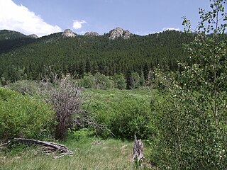
The ecology of the Rocky Mountains is diverse due to the effects of a variety of environmental factors. The Rocky Mountains are the major mountain range in western North America, running from the far north of British Columbia in Canada to New Mexico in the southwestern United States, climbing from the Great Plains at or below 1,800 feet (550 m) to peaks of over 14,000 feet (4,300 m). Temperature and rainfall varies greatly also and thus the Rockies are home to a mixture of habitats including the alpine, subalpine and boreal habitats of the Northern Rocky Mountains in British Columbia and Alberta, the coniferous forests of Montana and Idaho, the wetlands and prairie where the Rockies meet the plains, a different mix of conifers on the Yellowstone Plateau in Wyoming and in the high Rockies of Colorado and New Mexico, and finally the alpine tundra of the highest elevations.

The Sierra Madre Range is a mountain range in the western United States, located in south-central Wyoming and north-central Colorado. Geologically, it may be considered an extension of the Park Range of Colorado. South of the Great Divide Basin, the US Continental Divide runs along the Sierre Madre high points. Its western basins drain into the Colorado River and its eastern into the North Platte River. Buck Mountain is the highest peak in the range and lies within Colorado. Bridger Peak is its highest elevation on the Wyoming side of the range.

Little Cone is a prominent mountain summit in the San Miguel Mountains range of the Rocky Mountains of North America. The 11,988-foot (3,654 m) peak is located in Uncompahgre National Forest, 15.0 miles (24.1 km) west of the Town of Telluride in San Miguel County, Colorado, United States.


