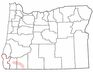
The Rogue Valley is a valley region in southwestern Oregon in the United States. Located along the middle Rogue River and its tributaries in Josephine and Jackson counties, the valley forms the cultural and economic heart of Southern Oregon near the California border. The largest communities in the Rogue Valley are Medford, Ashland and Grants Pass. The most populated part of the Rogue Valley is not along the Rogue proper, but along the smaller Bear Creek tributary. The Rogue Valley is a popular fall destination in Oregon because of the hardwood forests there.
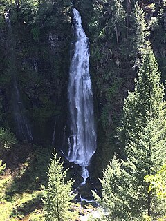
Barr Creek Falls, is a waterfall located in the Rogue River Canyon within the Prospect State Scenic Viewpoint in Jackson County, in the U.S. state of Oregon. The waterfall is located at the south end of Barr Creek as it plunges into the Rogue River over a carved cliff surrounded by walls of petrified volcanic ash as a consequence of the Mount Mazama eruption. The waterfall has also been called Bear Creek Falls. The waterfall gets its name from the creek which was called "Barr" for the presence of a fence that prevented cattle from straying out of the local Red Blanket Ranch and that ran adjacent to the creek.
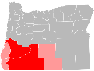
Southern Oregon is a region of the U.S. state of Oregon south of Lane County and generally west of the Cascade Range, excluding the southern Oregon Coast. Counties include Douglas, Jackson, Klamath, and Josephine. It includes the Southern Oregon American Viticultural Area, which consists of the Umpqua and Rogue River drainages. As of 2015, the population in the four counties is about 471,000, and in the greater, seven-county definition is about 564,000.

Shepperd's Dell is a small canyon in the Columbia River Gorge in Oregon, located at 45.54833°N 122.195°W which is less than one-third mile southeast of Rooster Rock State Park.
Umpqua Hot Springs is a geothermal pool located along the North Umpqua River in the U.S. state of Oregon at 2,640 feet (800 m) elevation. Two oval pools are available for soaking, the larger having a solid rock bottom and the smaller a bottom of coarse sand. The larger is five by eight feet and 110 °F (43 °C), and is covered by a wooden enclosure. The upper pool is smaller but slightly warmer, measuring four by five feet and 112 °F (44 °C). Both pools are approximately two and a half feet deep. Umpqua is clothing optional.

The Medford Oregon Temple is the 79th operating temple of The Church of Jesus Christ of Latter-day Saints.

Camp White was an Army training base located in Jackson County, Oregon, United States, during World War II. It was also the site of a prisoner-of-war (POW) camp. The camp was named in honor of George A. White, who served as adjutant general for Oregon starting in 1915.

Southwest Hills is a neighborhood in the West Hills in the southwest section of Portland, Oregon, United States. The northeastern part of the neighborhood, above Goose Hollow and Downtown Portland, is known as Portland Heights. Much of the western portion of the neighborhood lies outside the Portland city limits, in unincorporated Multnomah County.

Hargadine Cemetery is a cemetery in Ashland, Oregon, United States. It was established in 1867.
Tiller is an unincorporated community in Douglas County, Oregon, United States. It is located on Oregon Route 227 and the South Umpqua River, in the Umpqua National Forest.
Southern Oregon Speedway is a 3/8-mile banked dirt race track located near White City, Oregon, United States.
KSRG is a radio station licensed to Ashland, Oregon. The station is owned by the Southern Oregon University, and is an affiliate of Jefferson Public Radio, airing JPR's "Classics & News" service, consisting of news and classical music programming.

Mill Creek Falls, is a waterfall located in the Rogue River Canyon within the Prospect State Scenic Viewpoint in Jackson County, in the U.S. state of Oregon. The waterfall is located at the south end of Mill Creek as it plunges into the Rogue River over a carved cliff surrounded by walls of petrified volcanic ash consequence of Mount Mazama eruption.

Montara State Marine Reserve (SMR) and Pillar Point State Marine Conservation Area (SMCA) are two adjoining marine protected areas that extend offshore from Montara to Pillar Point in San Mateo County on California’s north central coast. The combined area of these marine protected areas is 18.42 square miles (47.7 km2), with 11.76 square miles (30.5 km2) in the SMR and 6.66 in the SMCA. Montara SMR prohibits the take of all living marine resources. Pillar Point SMCA prohibits the take of all living marine resources, except the recreational and commercial take of pelagic finfish by trolling or seine, the commercial or recreational take of Dungeness crab by trap and the commercial or recreational take or market squid by hand-held dip net or round haul net.

McCredie Springs is an unincorporated community in Lane County, Oregon. It is located near Oregon Route 58, about 10.7 miles (17.2 km) east of Oakridge, and 50.7 miles (81.6 km) east of Eugene. McCredie Springs is within the Willamette National Forest and is known for the nearby natural hot springs.
Drew is an unincorporated community in Douglas County, Oregon, United States. It is located about six miles south of Tiller and 21 miles north of Trail on Oregon Route 227, surrounded by the Umpqua National Forest.

North Bend Air Force Station is a closed United States Air Force General Surveillance Radar station. It is located 3.9 miles (6.3 km) north-northeast of Hauser, Oregon. It was closed in 1980.
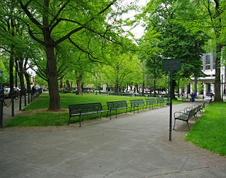
The Plaza Blocks, two courthouse squares known as Chapman Square and Lownsdale Square, are located in downtown Portland, Oregon. The blocks neighbor Terry Schrunk Plaza and are located near City Hall. The north square is named after Daniel H. Lownsdale (1803—1862), a native Kentuckian who settled in Portland in 1845. The south square is named after legislator William W. Chapman (1808–1892), a Virginian settled in Portland in 1850.
McLean Creek is a stream in Lincoln County in the U.S. state of Missouri.