Franklin County is a county in the U.S. state of Tennessee. It is located on the eastern boundary of Middle Tennessee in the southern part of the state. As of the 2020 census, the population was 42,774. Its county seat is Winchester. Franklin County is part of the Tullahoma-Manchester, TN Micropolitan Statistical Area.

Russell Cave National Monument is a U.S. national monument in northeastern Alabama, United States, close to the town of Bridgeport. The monument was established on May 11, 1961, when 310 acres (1.3 km2) of land were donated by the National Geographic Society to the American people. It is now administered and maintained by the National Park Service. The national monument was listed on the National Register of Historic Places on October 15, 1966.

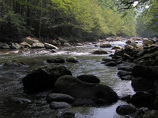
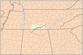
Little River is a 60-mile (97 km) river in Tennessee which drains a 380-square-mile (980 km2) area containing some of the most spectacular scenery in the southeastern United States. The first 18 miles (29 km) of the river are all located within the borders of the Great Smoky Mountains National Park. The remaining 42 miles (68 km) flow out of the mountains through Blount County to join the Tennessee River at Fort Loudon Lake in Knox County.

The Big South Fork of the Cumberland River is a 76-mile-long (122 km) river in the U.S. states of Tennessee and Kentucky. It is a major drainage feature of the Cumberland Plateau, a major tributary of the Cumberland River system, and the major feature of the Big South Fork National River and Recreation Area.
The Elk River is a tributary of the Tennessee River in the U.S. states of Tennessee and Alabama. The river is about 195 miles (314 km) long.
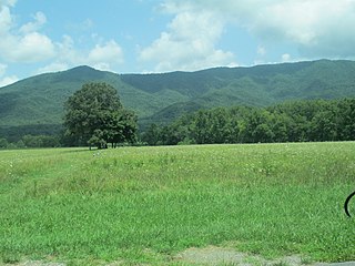
Cades Cove is an isolated valley located in the Tennessee section of the Great Smoky Mountains National Park. The valley was home to numerous settlers before the formation of the national park. Today Cades Cove, the single most popular destination for visitors to the park, attracts more than two million visitors a year because of its well preserved homesteads, scenic mountain views, and abundant display of wildlife. The Cades Cove Historic District is listed on the National Register of Historic Places.

Pictograph Cave is an area of three caves located 5 miles (8.0 km) south of Billings, Montana, United States, preserved and protected in the 23-acre (9.3 ha) Pictograph Cave State Park.

Nanih Waiya is an ancient platform mound in southern Winston County, Mississippi, constructed by indigenous people during the Middle Woodland period, about 300 to 600 CE. Since the 17th century, the Choctaw have venerated Nanih Waiya mound and a nearby cave as their sacred origin location.

South Cumberland State Park is a state park in the middle and southeast portions of Tennessee on the Cumberland Plateau.

The Stanfield-Worley Bluff Shelter, located on private property in Colbert County in northwestern Alabama, United States, is one of the most important prehistoric sites excavated in the state due to the archeological evidence deposited by the Paleo-Indians who once occupied the rock shelter. Lying in Sanderson Cove along a tributary of Cane Creek approximately seven miles (11 km) south of the Tennessee Valley, the shelter and the high bluffs of the surrounding valley provided a well-protected environment for the Native American occupants.

Germany Valley is a scenic upland valley high in the Allegheny Mountains of eastern West Virginia originally settled by German farmers in the mid-18th century. It is today a part of the Spruce Knob–Seneca Rocks National Recreation Area of the Monongahela National Forest, although much ownership of the Valley remains in private hands.

Scott's Gulf is a canyon situated along the Caney Fork River in White County, Tennessee, in the southeastern United States. The canyon stretches for approximately 18 miles (29 km) as the Caney Fork drops from the top of the Cumberland Plateau down to the eastern Highland Rim. This remote section of the river is home to a wilderness area consisting of a largely undisturbed deciduous forest, numerous waterfalls, caves and other geological formations, and Class IV and Class V whitewater rapids.

Graham Cave is a Native American archeological site near Mineola, Missouri in Montgomery County in the hills above the Loutre River. It is located in the 356 acre Graham Cave State Park. The entrance of the sandstone cave forms a broad arch 120 feet (37 m) wide and 16 feet (5 m) high. Extending about 100 feet (30 m) into the hillside, the cave protects an historically important Pre-Columbian archaeological site from the ancient Dalton and Archaic period dating back to as early as 10,000 years ago.

Graham Cave State Park is a state park in the U.S. state of Missouri consisting of 369 acres (149 ha) located in Montgomery County. The park's namesake, Graham Cave, is a cave in St. Peter sandstone with an entrance 120 feet (37 m) wide and 60 feet (18 m) high and an extent of about 100 feet (30 m) into the hillside. The cave protects an historically important Pre-Columbian archaeological site dating back to as early as 10,000 years ago. Visitors are allowed up to the entrance of the cave where interpretive signs point out significant discoveries. The park includes the 82-acre (33 ha) Graham Cave Glades Natural Area which protects an area of sandstone and dolomite glades with a rich diversity of glade species. The park is adjacent to Interstate 70 from which the entrance to the cave can be glimpsed during foliage-free months.

The Castalian Springs Mound State Historic Site (40SU14) is a Mississippian culture archaeological site located near the small unincorporated community of Castalian Springs in Sumner County, Tennessee. The site was first excavated in the 1890s and again as recently as the 2005 to 2011 archaeological field school led by Dr. Kevin E. Smith. A number of important finds have been associated with the site, most particularly several examples of Mississippian stone statuary and the Castalian Springs shell gorget held by the National Museum of the American Indian. The site is owned by the State of Tennessee and is a State Historic Site managed by the Bledsoe's Lick Association for the Tennessee Historical Commission. The site is not currently open to the public.

Sherwood is an unincorporated community in Franklin County, Tennessee, United States. It is located along Tennessee State Route 56 13.1 miles (21.1 km) southeast of Winchester, and just north of the Alabama state line. Sherwood has a post office with ZIP code 37376.

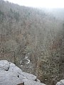
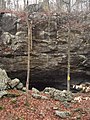
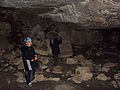
Lost Cove is a small valley in southern Tennessee near the Alabama border. It is noted for its history including Native American and Appalachian Settlements as well as its natural formations including Caves and Sinkholes.