
Fort Monroe is a decommissioned military installation in Hampton, Virginia at Old Point Comfort, the southern tip of the Virginia Peninsula, United States. Along with Fort Wool, Fort Monroe originally guarded the navigation channel between the Chesapeake Bay and Hampton Roads—the natural roadstead at the confluence of the Elizabeth, the Nansemond and the James rivers. Until disarmament in 1946, the areas protected by the fort were the entire Chesapeake Bay and Potomac River regions, including the water approaches to the cities of Washington, D.C. and Baltimore, Maryland, along with important shipyards and naval bases in the Hampton Roads area. Surrounded by a moat, the six-sided bastion fort is the largest fort by area ever built in the United States.

Fort Stevens was an American military installation that guarded the mouth of the Columbia River in the state of Oregon. Built near the end of the American Civil War, it was named for a slain Civil War general and former Washington Territory governor, Isaac Stevens. The fort was an active military reservation from 1863–1947. It is now listed on the National Register of Historic Places.
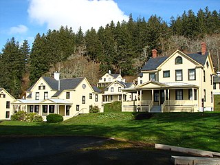
Fort Columbia State Park is a public recreation area and historic preserve at the site of former Fort Columbia, located on Chinook Point at the mouth of the Columbia River in Chinook, Washington. The 618-acre (250 ha) state park features twelve historic wood-frame fort buildings as well as an interpretive center and hiking trails. The park's grounds are located over a tunneled section of U.S. Route 101.

15th Field Artillery Regiment, RCA, is a Primary Reserve Royal Canadian Artillery (RCA) regiment based in Vancouver, British Columbia, at the Bessborough Armoury. 15th Field Regiment is part of the 39 Canadian Brigade Group of 3rd Canadian Division.
Trembleur Lake Provincial Park is a provincial park in British Columbia, Canada.

Montauk Air Force Station was a US military base at Montauk Point on the eastern tip of Long Island, New York. It was decommissioned in 1981 and is now owned by the New York State Office of Parks, Recreation and Historic Preservation as Camp Hero State Park.

Whitsand Bay, situated in south east Cornwall, England, United Kingdom runs from Rame Head in the east to Portwrinkle in the west. It is characterised by sheer, high cliffs, dramatic scenery and long stretches of sandy beaches. The South West Coast Path runs the length of the bay.

Fort Rodd Hill National Historic Site is a 19th-century coastal artillery fort on the Colwood, British Columbia side of Esquimalt Harbour,. The site is adjacent to Fisgard Lighthouse National Historic Site, the first lighthouse on the west coast of Canada. Both the fort and lighthouse are managed and presented to the public by Parks Canada.
Fort Tilden, also known as Fort Tilden Historic District, is a former United States Army installation on the coast in the New York City borough of Queens. Fort Tilden now forms part of the Gateway National Recreation Area, and is administered by the National Park Service.

The HeughGun Battery is located on the Headland at Hartlepool, County Durham, England.
Read Island is an island in British Columbia, Canada. It is part of the Discovery Islands between Vancouver Island and the mainland, between the Strait of Georgia and Johnstone Strait.
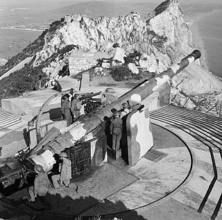
The BL 9.2-inch Mk IX and Mk X guns were British breech loading 9.2-inch guns of 46.7 calibre, in service from 1899 to the 1950s as naval and coast defence guns. They had possibly the longest, most varied and successful service history of any British heavy ordnance.
The Pembroke Range is a small mountain range in southwestern British Columbia, Canada, located between Loughborough Inlet and Phillips Arm. It has an area of 75 km2 and is a subrange of the Pacific Ranges which in turn form part of the Coast Mountains.
The Bombardment of Fort Stevens occurred in June 1942, in the American Theater and the Pacific Theater of World War II. An Imperial Japanese submarine fired on Fort Stevens, which defended the Oregon side of the Columbia River's Pacific entrance.
Yorke Island is a small islet located off of the north end of Hardwicke Island in the south end of Johnstone Strait. Located in the Inside Passage, it occupies a choke point at the split of Johnstone Strait and Sunderland Channel which all vessels traveling between the Mainland and Vancouver Island have to pass. As Hardwicke Island separates two channels offering passages between Vancouver Island and the mainland coast of British Columbia, Yorke Island was strategically placed to protect the entrances of what was considered the backdoor access to Vancouver during World War II.

Fort Heath was a US seacoast military installation for defense of the Boston and Winthrop Harbors with an early 20th-century Coast Artillery fort, a 1930s USCG radio station, prewar naval research facilities, World War II batteries, and a Cold War radar station. The fort was part of the Harbor Defenses of Boston and was garrisoned by the United States Army Coast Artillery Corps. The fort's military structures have been replaced by a residential complex, including the luxurious Forth Heath Apartments, and recreation facilities of Small Park, which has both a commemorative wall and an historical marker for Fort Heath.
Fairview Point is a point or headland on the west side of Kaien Island on the North Coast of British Columbia, Canada.
Hoeya Sound is a small sound or bay on the north side of Knight Inlet on the Central Coast of British Columbia, Canada, just east of Lull Bay. The Kwakwaka'wakw villages of igisbalis and Nalakglala were located on the sound, the former just behind Hoeya Head, the point on the south side of the entrance to the sound, the latter at its head.


