Madisonville, Missouri

Last updated

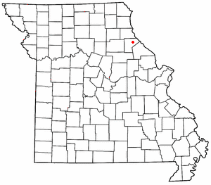
Madisonville is an unincorporated community in Ralls County, in the U.S. state of Missouri. [1] The community lies approximately four miles southeast of Center and on the banks of Spencer Creek. [2]

Ralls County, Missouri U.S. county in Missouri

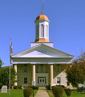
Ralls County is a county located in the northeastern portion of the U.S. state of Missouri. As of the 2010 census, the population was 10,167. Its county seat is New London. The county was organized November 16, 1820 and named for Daniel Ralls, Missouri state legislator.

U.S. state constituent political entity of the United States

In the United States, a state is a constituent political entity, of which there are currently 50. Bound together in a political union, each state holds governmental jurisdiction over a separate and defined geographic territory and shares its sovereignty with the federal government. Due to this shared sovereignty, Americans are citizens both of the federal republic and of the state in which they reside. State citizenship and residency are flexible, and no government approval is required to move between states, except for persons restricted by certain types of court orders.

Missouri U.S. state in the United States

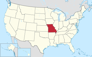
Missouri is a state in the Midwestern United States. With over six million residents, it is the 18th-most populous state of the Union. The largest urban areas are St. Louis, Kansas City, Springfield and Columbia; the capital is Jefferson City. The state is the 21st-most extensive in area. Missouri is bordered by eight states : Iowa to the north, Illinois, Kentucky and Tennessee to the east, Arkansas to the south and Oklahoma, Kansas and Nebraska to the west. In the South are the Ozarks, a forested highland, providing timber, minerals and recreation. The Missouri River, after which the state is named, flows through the center of the state into the Mississippi River, which makes up Missouri's eastern border.

History

Madisonville was platted in 1836, and named after James Madison Croswaite, the sibling of a first settler. [3] A post office called Madisonville was established in 1838, and remained in operation until 1906. [4]

Plat map showing a piece of land, drawn to scale, with details such as nearby properties, boundaries, land size, flood zones, the surrounding neighborhood, easements, and monuments

In the United States, a plat is a map, drawn to scale, showing the divisions of a piece of land. United States General Land Office surveyors drafted township plats of Public Lands Surveys to show the distance and bearing between section corners, sometimes including topographic or vegetation information. City, town or village plats show subdivisions into blocks with streets and alleys. Further refinement often splits blocks into individual lots, usually for the purpose of selling the described lots; this has become known as subdivision.

Related Research Articles

Saverton, Missouri unincorporated community in Missouri

Saverton is an unincorporated community in eastern Ralls County, Missouri, United States. It is located on the Mississippi River, approximately ten miles southeast of Hannibal. Saverton is part of the Hannibal Micropolitan Statistical Area.

Spencer Creek is a stream in Ralls and Pike counties of the U.S. state of Missouri. It is a tributary of the Salt River. The stream headwaters arise in the western edge of Pike County adjacent to the south side of Missouri Route 154 about 7 miles (11 km) west of Curryville. The stream flows generally west passing about 2 miles (3.2 km) north of Vandalia then turns northwest crossing under Route 154 east of Liberty Hall. The stream turns north then northeast and passes the village of Madisonville and continues roughly parallel to the boundary between Ralls and Pike counties. It enters briefly into Pike County just prior to passing under U.S. Route 61. It enters the Salt River about 4 miles (6.4 km) southeast of New London.

Cincinnati is an unincorporated community in Ralls County, in the U.S. state of Missouri.

Flint Hill is an unincorporated community in Ralls County, in the U.S. state of Missouri.

Greenlawn is an unincorporated community in Ralls County, in the U.S. state of Missouri.

Hassard is an unincorporated community in Ralls County, in the U.S. state of Missouri.

Hatch is an unincorporated community in Ralls County, in the U.S. state of Missouri.

Hippo Branch is a stream in Ralls County in the U.S. state of Missouri. It is a tributary of Spencer Creek. The stream headwaters arise just southeast of Missouri Route 19 and it flows east-southeast to its confluence with Spencer Creek one mile east of Madisonville.

Huntington is an unincorporated community in Ralls County, in the U.S. state of Missouri.

Hutchison is an unincorporated community in Ralls County, in the U.S. state of Missouri.

Hydesburg is an extinct town in Ralls County, in the U.S. state of Missouri.

Ilasco is an unincorporated community in Ralls County, in the U.S. state of Missouri.

Joanna is an extinct town in Ralls County, in the U.S. state of Missouri. The GNIS classifies it as a populated place.

Noonan is an extinct town in Ralls County, in the U.S. state of Missouri.

Salt River is an unincorporated community in Ralls County, in the U.S. state of Missouri.

Sheil is an unincorporated community in Ralls County, in the U.S. state of Missouri.

Spalding is an unincorporated community in Ralls County, in the U.S. state of Missouri.

West Hartford is an unincorporated community in Ralls County, in the U.S. state of Missouri.

Saverton Township is an inactive township in Ralls County, in the U.S. state of Missouri.

References

  1. U.S. Geological Survey Geographic Names Information System: Madisonville, Missouri
  2. Missouri Atlas & Gazetteer, DeLorme, 1998, First edition, p. 32, ISBN   0-89933-224-2
  3. "Ralls County Place Names, 1928–1945". The State Historical Society of Missouri. Archived from the original on June 24, 2016. Retrieved December 11, 2016.
  4. "Post Offices". Jim Forte Postal History. Retrieved 27 November 2016.

Coordinates: 39°27′26″N91°29′48″W / 39.45722°N 91.49667°W / 39.45722; -91.49667

Geographic coordinate system Coordinate system

A geographic coordinate system is a coordinate system that enables every location on Earth to be specified by a set of numbers, letters or symbols. The coordinates are often chosen such that one of the numbers represents a vertical position and two or three of the numbers represent a horizontal position; alternatively, a geographic position may be expressed in a combined three-dimensional Cartesian vector. A common choice of coordinates is latitude, longitude and elevation. To specify a location on a plane requires a map projection.