This article needs additional citations for verification .(December 2009) (Learn how and when to remove this template message) |
Mahlabatini | |
|---|---|
 Mahlabatini  Mahlabatini | |
| Coordinates: 28°15′S31°26′E / 28.250°S 31.433°E Coordinates: 28°15′S31°26′E / 28.250°S 31.433°E | |
| Country | South Africa |
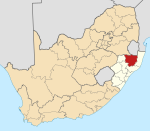
| Province | KwaZulu-Natal |
| District | Zululand |
| Municipality | Ulundi |
| Area | |
| • Total | 8.94 km2 (3.45 sq mi) |
| Population (2011) [1] | |
| • Total | 1,511 |
| • Density | 170/km2 (440/sq mi) |
| Racial makeup (2011) | |
| • Black African | 98.4% |
| • Coloured | 0.7% |
| • Indian/Asian | 0.1% |
| • White | 0.6% |
| • Other | 0.2% |
| First languages (2011) | |
| • Zulu | 96.7% |
| • Other | 3.3% |
| Time zone | UTC+2 (SAST) |
| PO box | 3865 |
| Area code | 035 |
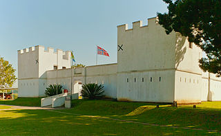
Mahlabatini is a small town in KwaZulu-Natal, South Africa. It was established in 1898 by the British.

KwaZulu-Natal is a province of South Africa that was created in 1994 when the Zulu bantustan of KwaZulu and Natal Province were merged. It is located in the southeast of the country, enjoying a long shoreline beside the Indian Ocean and sharing borders with three other provinces and the countries of Mozambique, Eswatini and Lesotho. Its capital is Pietermaritzburg and its largest city is Durban. It is the 2nd most populous province in South Africa, with slightly fewer residents than Gauteng.

South Africa, officially the Republic of South Africa (RSA), is the southernmost country in Africa. It is bounded to the south by 2,798 kilometres (1,739 mi) of coastline of Southern Africa stretching along the South Atlantic and Indian Oceans; to the north by the neighbouring countries of Namibia, Botswana, and Zimbabwe; and to the east and northeast by Mozambique and Eswatini (Swaziland); and it surrounds the enclaved country of Lesotho. South Africa is the largest country in Southern Africa and the 25th-largest country in the world by land area and, with over 57 million people, is the world's 24th-most populous nation. It is the southernmost country on the mainland of the Old World or the Eastern Hemisphere. About 80 percent of South Africans are of Sub-Saharan African ancestry, divided among a variety of ethnic groups speaking different African languages, nine of which have official status. The remaining population consists of Africa's largest communities of European (White), Asian (Indian), and multiracial (Coloured) ancestry.

The United Kingdom (UK), officially the United Kingdom of Great Britain and Northern Ireland, and sometimes referred to as Britain, is a sovereign country located off the north-western coast of the European mainland. The United Kingdom includes the island of Great Britain, the north-eastern part of the island of Ireland, and many smaller islands. Northern Ireland is the only part of the United Kingdom that shares a land border with another sovereign state, the Republic of Ireland. Apart from this land border, the United Kingdom is surrounded by the Atlantic Ocean, with the North Sea to the east, the English Channel to the south and the Celtic Sea to the south-west, giving it the 12th-longest coastline in the world. The Irish Sea lies between Great Britain and Ireland. With an area of 242,500 square kilometres (93,600 sq mi), the United Kingdom is the 78th-largest sovereign state in the world. It is also the 22nd-most populous country, with an estimated 66.0 million inhabitants in 2017.
Village 48 km south-west of Nongoma. Established as a Norwegian mission station, it became the seat of magistracy of the Mahlabatini district. The name is Zulu, said to mean ‘country of white, sandy soil’. Known locally as Mashona, situated on the Mashona Engashoni Ridge. [2]

Nongoma is a town in Zululand, KwaZulu-Natal, South Africa. It is the seat of the Nongoma Local Municipality. It is situated 300 km north of Durban and 56 km from Ulundi; it is surrounded by the Ngome Forest. It is a busy market town that serves a large surrounding area. It is assigned registration plate NND.
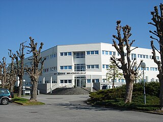
The Norwegian Mission Society is the first and oldest mission organization in Norway.
Neighbouring localities include Ulundi (10 km); Melmoth (55 km); Nongoma (53 km); Hlabisa (99 km). [3]

Ulundi, also known as Mahlabathini is a town in the Zululand District Municipality. At one time the capital of Zululand in South Africa and later the capital of the Bantustan of KwaZulu, Ulundi now lies in KwaZulu-Natal Province. The town now includes Ulundi Airport, a three-star hotel, and some museums amongst its sights. In the 2001 Census, the population of the town was recorded as 18,420.

Melmoth is a small town situated in KwaZulu-Natal, South Africa. The town was established in the Mthonjaneni district after the annexation of Zululand by the United Kingdom in 1887 and was named after Sir Melmoth Osborn. Large wattle plantations were set up and a wattle bark factory was established in 1926. The district is also planted with sugar cane from the outskirts of the town and into the surrounding villages. The government-funded hospital in Melmoth is St Marys kwaMagwaza Hospital that caters for the people of Melmoth and surrounding villages.
Hlabisa is a settlement in Umkhanyakude District Municipality in the KwaZulu-Natal province of South Africa. The village lies between the Hluhluwe and Umfolozi game reserves, some 40 km north-west of Mtubatuba. Named after the Hlabisa tribe of Zulus.