A post office is a public facility and a retailer that provides mail services, such as accepting letters and parcels, providing post office boxes, and selling postage stamps, packaging, and stationery. Post offices may offer additional services, which vary by country. These include providing and accepting government forms, and processing government services and fees. The chief administrator of a post office is called a postmaster.

A police station is a building which serves to accommodate police officers and other members of police staff. Police stations typically contain offices and accommodation for personnel and vehicles, along with locker rooms, temporary holding cells and interview/interrogation rooms.
Mainpuri is a city in Mainpuri district in the Indian state of Uttar Pradesh. It is the administrative headquarters of Mainpuri district and is situated to the north-east of Agra and is 270 km from New Delhi. Mainpuri is located in the Braj region, which holds special religious significance to Hindus as the homeland of Krishna.

Koraput district is a district of India in southern Odisha, with headquarters at Koraput. The district is located in the Eastern Ghats and is known for its hilly terrain, rich and diverse types of mineral deposits and its tribal culture and traditions. The district headquarters town of Koraput and its largest city, Jeypore are major centres of trade and commerce for South Odisha and fall on an important road connecting Visakhapatnam to Raipur.

Mainpuri district is one of the districts in the Agra division of Uttar Pradesh, India. Mainpuri town is the district headquarters. It consists of six tehsils, namely Mainpuri, Bhongaon, Karhal, Kishni, Kurawali and Ghiror.

Vellore district is one of the 38 districts in the Tamil Nadu state of India. It is one of the eleven districts that form the north region of Tamil Nadu. Vellore city is the headquarters of this district. As of 2011, the district had a population of 1,614,242 with a sex ratio of 1,007 females for every 1,000 males. In 2017 Vellore district ranked eleventh in list of districts in Tamil Nadu by Human Development Index.

Raebareli district is a district of Uttar Pradesh state in northern India. The city of Raebareli is the district headquarters. This district is a part of Lucknow Division in Uttar Pradesh state. The total area of Raebareli district is 3,371 Sq. km.

Thoubal district is one of the sixteen districts of Manipur state in northeastern India. This district is bounded by Senapati district on the north, Ukhrul and Chandel districts on the east, Churchandpur and Bishnupur districts on the south and Imphal West and Imphal East districts on the west. The district occupies an area of 324 km2. The population as of 2011 is 286,687. Thoubal town is the district headquarters. This district is known for Khongjom, where the last battle of the independence of Manipur was fought in April 1891 against the British army.
Aranthangi is a town in Pudukkottai district in the state of Tamil Nadu, India. As of 2011, it had a population of 40,814.

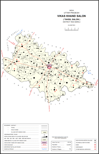
Salon is a town and nagar panchayat in Raebareli district in the Indian state of Uttar Pradesh. It serves as the headquarters of a tehsil as well as a community development block. Originally it was also the headquarters of the entire district, but they were moved after the Indian Rebellion of 1857. It is located a bit to the south of the Sai river, at the junction of the Raebareli-Pratapgarh and Jais-Khaga roads. Other roads lead to Dalmau, Manikpur, and Kunda. To the east is a large jhil.
Julana is a municipal committee town in the Jind district in the Haryana state of India. It is positioned in the Interior of Haryana and is usually known as the Heart of Haryana. It is the administrative headquarters of Julana Tehsil, located in the middle of Rohtak and Jind on NH 71.

Nediyiruppu was the capital of the Zamorin's kingdom in colonial Kerala. At the time, it was known as Nediyiruppu Swaroopam. It is a region of the Kondotty municipality in Malappuram district, Kerala, India. It is situated 24 kilometres (15 mi) from Malappuram, the district headquarters.
Pimpalner, is a small town in Parner Taluka in Ahmednagar district of state of Maharashtra, India. It belongs to Nashik Division. It is located 49 km to the west of District headquarters Ahmednagar. 12 km from Parner. 189 km from State capital Mumbai. Pimpalner is surrounded by Parner Taluka to the north, Ahmednagar Taluka to the east, Shrigonda Taluka to the south, Khed Taluka to the west. Shirur, Ahmednagar, Shrigonda, Manchar are the nearby cities to Pimpalner.

Govindpur Jhakhraha is a small village in the historical Vaishali district of Bihar, India. It is located across NH 322 at 13 km east of district headquarters Hajipur. The village falls under Bakarpur Panchayat of Rajapakar community development block. The population of the village is approximately 1800. Bajjika is the main dialect but Hindi and Urdu is the medium of study. English is understood and spoken by a few elites of the village.
Walajabad taluk is a taluk in the Kanchipuram district of Tamil Nadu, India. At the 2011 Census of India, the taluk covered an area of 339.03 square kilometres (130.90 sq mi) with a population of 125,868. The headquarters of the taluk is the town of Walajabad.
Kalyanpur is a small village and, It is a located in the Sonpur tehsil (Block) of Saran district of the state of Bihar, India. It is an altitude of 43 meters (141 ft). Kalyanpur village is situated at an 8 km (4 mi) away from the Sub-district headquarters of Sonpur and the 47 km (29 mi) away from the district headquarter of Chhapra. As per 2009 stats, Kalyanpur is the gram panchayat of Kalyanpur village. Nearby the Gularia Chowk is the small market in a kalyanpur village. Sonpur is the nearest town is an approximately 8 km away from the kalyanpur. Kalyanpur village connected by Sonpur Darihara Rewaghat road to Gandak baandh road.

Behta Kalan is a village in Lalganj block of Rae Bareli district, Uttar Pradesh, India. It is located 8 km (5.0 mi) from Lalganj, the block and tehsil headquarters, a bit to the north of the road connecting it and Rae Bareli, the district headquarters.

Gaura Hardo, or just Gaura, is a village in Rae Bareli district, Uttar Pradesh, India. It serves as the headquarters of Deenshah Gaura block, in the tehsil of Dalmau. It is located 33 km from Raebareli, the district headquarters, on the road from Dalmau to Salon. As of 2011, Gaura Hardo has a population of 8,001 people, in 1,446 households. It has five primary schools and one maternity and child welfare centre.

Dih, also spelled Deeh, is a dessert and corresponding community development block in Salon tehsil of Rae Bareli district, Uttar Pradesh, India. It is located 22 km from Raebareli, the district headquarters, near the point where the road to Parshadepur intersects the road leading from Jais to the Gukana ghat. The Sai river flows a short distance to the south. As of 2011, Dih has a population of 12,110 people, in 2,186 households. It has three primary schools and no healthcare facilities, as well as a post office, a library, and an Anganwadi centre. It is the headquarters of a nyaya panchayat, which also includes 8 other villages.

Mau is a large village in Dih block of Rae Bareli district, Uttar Pradesh, India. It is located on the road from Fursatganj to the Gukana ghat on the Ganges, 4 miles west of Nasirabad and 8 miles from Jais. A road branches off at Mau and connects to Nasirabad. To the northwest of the village is a large lake called the Bara Tal.


