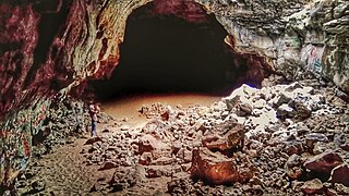
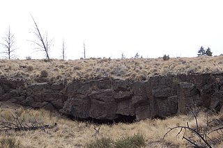
Mammoth Cave is a lava tube located on the Markagunt Plateau in the Dixie National Forest of Southern Utah, and is one of the largest lava tubes in Utah. The cave has over 2,200 feet (670 m) of passage and is about a quarter mile (400 m) long. It was formed by cooling lava and water less than 2,000 years ago. Due to moisture and its elevation of 8,050 feet (2,450 m) above sea level the cave stays cool year round.
The cave has four chambers, the largest to the west. At the end of the largest tunnel, it narrows to a small opening that can be used as an exit. Although the cave is open year round, portions of it are closed off from October until April to protect hibernating bats. Additionally, Mammoth Creek Road may be completely impassable during the winter months due to snowfall.
A cave or cavern is a natural void in the ground, specifically a space large enough for a human to enter. Caves often form by the weathering of rock and often extend deep underground. The word cave can refer to smaller openings such as sea caves, rock shelters, and grottos, and they are called endogene caves. Caves which are deeper than its opening is wide are called exogene.
A stalactite (, ; from the Greek 'stalaktos' via stalassein is a mineral formation that hangs from the ceiling of caves, hot springs, or man-made structures such as bridges and mines. Any material that is soluble and that can be deposited as a colloid, or is in suspension, or is capable of being melted, may form a stalactite. Stalactites may be composed of lava, minerals, mud, peat, pitch, sand, sinter, and amberat. A stalactite is not necessarily a speleothem, though speleothems are the most common form of stalactite because of the abundance of limestone caves.
Lava Beds National Monument is located in northeastern California, in Siskiyou and Modoc counties. The monument lies on the northeastern flank of Medicine Lake Volcano and has the largest total area covered by a volcano in the Cascade Range.
Newberry National Volcanic Monument was designated on November 5, 1990, to protect the area around the Newberry Volcano in the U.S. state of Oregon. The monument was created within the boundaries of the Deschutes National Forest, which is managed by the U.S. Forest Service, and includes 54,822 acres of lakes, lava flows, and geologic features in central Oregon.
Devils Postpile National Monument is a U.S. National Monument located near Mammoth Mountain in Eastern California. The monument protects Devils Postpile, an unusual rock formation of columnar basalt. It encompasses 798 acres (323 ha) and includes two main attractions: the Devils Postpile formation and Rainbow Falls, a waterfall on the Middle Fork of the San Joaquin River. In addition, the John Muir Trail and Pacific Crest Trail merge into one trail as they pass through the monument. Excluding a small developed area containing the monument headquarters, visitor center and a campground, the National Monument lies within the borders of the Ansel Adams Wilderness.
Newberry Volcano is a large active shield-shaped stratovolcano located about 20 miles (32 km) south of Bend, Oregon, United States, 35 miles (56 km) east of the major crest of the Cascade Range, within the Newberry National Volcanic Monument. Its highest point is Paulina Peak. The largest volcano in the Cascade Volcanic Arc, Newberry has an area of 1,200 square miles (3,100 km2) when its lava flows are taken into account. From north to south, the volcano has a length of 75 miles (121 km), with a width of 27 miles (43 km) and a total volume of approximately 120 cubic miles (500 km3). It was named for the geologist and surgeon John Strong Newberry, who explored central Oregon for the Pacific Railroad Surveys in 1855. The surrounding area has been inhabited by Native American populations for more than 10,000 years.
Mount Adams, known by some Native American tribes as Pahto or Klickitat, is a potentially active stratovolcano in the Cascade Range. Although Adams has not erupted in more than 1,000 years, it is not considered extinct. It is the second-highest mountain in Washington, after Mount Rainier.
The Green River is a 384-mile-long (618 km) tributary of the Ohio River that rises in Lincoln County in south-central Kentucky. Tributaries of the Green River include the Barren River, the Nolin River, the Pond River and the Rough River. The river was named after Nathanael Greene, a general of the American Revolutionary War.
A lava tube, or pyroduct, is a natural conduit formed by flowing lava from a volcanic vent that moves beneath the hardened surface of a lava flow. If lava in the tube empties, it will leave a cave.
A lava cave is any cave formed in volcanic rock, though it typically means caves formed by volcanic processes, which are more properly termed volcanic caves. Sea caves, and other sorts of erosional and crevice caves, may be formed in volcanic rocks, but through non-volcanic processes and usually long after the volcanic rock was emplaced.
The Lava River Cave near Bend, Oregon, is part of the Newberry National Volcanic Monument, which is managed by the United States Forest Service. At 5,211 feet (1,588 m) in length, the northwest section of the cave is the longest continuous lava tube in Oregon. While the cave's discovery in 1889 was officially credited to a pioneer hunter, the presence of obsidian flakes near the cave has led archaeologists to conclude that Native Americans knew about the cave long before settlers arrived in central Oregon.
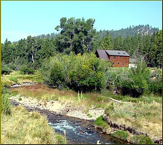
Mammoth Creek is a creek in Iron and Garfield counties in southern Utah, United States, that flows for over 20 miles (32 km) through mountains and forests from Mammoth Summit, through the Mammoth Valley, to its confluence with the Sevier River. The creek contains wild brown trout and hatchery rainbow trout.
Pluto's Cave is a partially collapsed lava tube on the northern outskirts of Mount Shasta in the Klamath National Forest. Its main entrance is located close to the 99-97 Cutoff c. 12 miles (19 km) North-east of Weed and c. 14 miles (23 km) East-southeast of Grenada. The tube is roughly 190,000 years old, which is quite old for a lava tube, as they normally collapse quickly, having ceilings only a few metres thick. However, Pluto's Cave is located in a semi-arid climate, where erosion is restricted, which contributes to its survival.
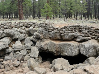
Lava River Cave is a lava tube in northern Arizona's Coconino National Forest. At approximately 0.75-mile (1.21 km) long, it is the longest cave of its kind known in Arizona. The cave was discovered by some lumbermen in 1915 and has historically been referred to as "Government Cave" due to its location on the eastern edge of Government Prairie and southeast of Government Peak. Today, Lava River Cave is freely accessible to the general public.
The Arnold Lava Tube System is series of lava tubes in Deschutes County, Oregon, in the United States. It is located several miles southeast of the city of Bend. The system starts in the Deschutes National Forest on the northern flank of Newberry Volcano, heads northeast onto BLM land before finally terminating on private property near Horse Ridge. The system acted as a conduit for the lavas from Lava Top Butte that later fed the Badlands rootless shield. The lava flow that created the Arnold system is also referred to as the basalt of Lava Top Butte and is related to the Horse Cave lobe which is a lava flow that created the Horse Lava Tube System. The lava flows of Lava Top Butte, the Badlands, the Horse system, and the Arnold system all have a geologic age around 80,000 years old.
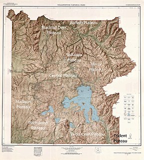
There are nine named plateaus in Yellowstone National Park. These plateaus are part of the much larger Yellowstone Plateau and dominate areas in the park south and west of the Gallatin and Absaroka mountain ranges. Four of the plateaus are from rhyolite lava flows that occurred between 110,000 and 70,000 years ago.
Derrick Cave is a lava tube located in the remote northwest corner of Lake County, Oregon. The cave is approximately 1,200 feet (370 m) long. It is up to 80 feet (24 m) wide and 46 feet (14 m) high in places. It was named in honor of H.E. Derrick, a pioneer rancher with a homestead 3 miles (4.8 km) southeast of the cave. The land around the cave is managed by the United States Department of Interior, Bureau of Land Management. Derrick Cave is open to the public year-round; however, camping is no longer permitted in the cave.
The Búri cave is a lava tube located in southwestern Iceland and was discovered in 1992, by the volcanologist Guðmundur Þorsteinsson.
Markagunt Plateau is a volcanic field in southern Utah, United States. Formed in a region of older volcanics, it consists of several cinder cones and associated lava flows. Some of the lava flows feature lava tubes such as Mammoth Cave, while others have formed lava dams and lakes like Navajo Lake. Volcanism took place during the Pliocene and latest Pleistocene but may have continued into the Holocene; legends of the Southern Paiute may reflect past eruptions.
This page is based on this Wikipedia article Text is available under the CC BY-SA 4.0 license; additional terms may apply. Images, videos and audio are available under their respective licenses.