Merritt, South Dakota | |
---|---|
Town | |
Coordinates: 44°08′27″N103°34′07″W / 44.14083°N 103.56861°W Coordinates: 44°08′27″N103°34′07″W / 44.14083°N 103.56861°W [1] | |
Country | United States |
State | South Dakota |
Counties | Lawrence and Pennington |
Elevation [1] | 5,105 ft (1,556 m) |
Time zone | MST (UTC-7) |
• Summer (DST) | MDT (UTC-6) |
Merritt is a ghost town in Lawrence County and Pennington County, South Dakota, United States of America. [1]
A ghost town is an abandoned village, town, or city, usually one that contains substantial visible remains. A town often becomes a ghost town because the economic activity that supported it has failed, or due to natural or human-caused disasters such as floods, prolonged droughts, government actions, uncontrolled lawlessness, war, pollution, or nuclear disasters. The term can sometimes refer to cities, towns, and neighbourhoods that are still populated, but significantly less so than in past years; for example, those affected by high levels of unemployment and dereliction.
Lawrence County is a county in the U.S. state of South Dakota. As of the 2010 United States Census, the population was 24,097. Its county seat is Deadwood.
Pennington County is a county in the U.S. state of South Dakota. As of the 2010 United States Census, the population was 100,948, making it the second-most populous county in South Dakota. Its county seat is Rapid City. The county was created in 1875, and was organized in 1877. It is named for John L. Pennington, fifth Governor of Dakota Territory, who held office in 1875 when the county was formed.
Merritt was a small logging community that once included a school, post office, and a ranger station. It provided fuel and wood for the mines near Lead and Deadwood. It has since been abandoned. In the 1970s, all that remained of the town was a trout ranch. [2]
Lead is a city in Lawrence County, South Dakota, United States. The population was 3,124 at the 2010 census. Lead is located in western South Dakota, in the Black Hills near the Wyoming state line.
Deadwood is a city in South Dakota, United States, and the county seat of Lawrence County. It was named by early settlers after the dead trees found in its gulch. The city had its heyday from 1876 to 1879, after gold deposits had been discovered there, leading to the Black Hills Gold Rush. At its height, the city had a population of 5,000, and attracted larger-than-life Old West figures including Wyatt Earp, Calamity Jane and Wild Bill Hickok.
Trout is the common name for a number of species of freshwater fish belonging to the genera Oncorhynchus, Salmo and Salvelinus, all of the subfamily Salmoninae of the family Salmonidae. The word trout is also used as part of the name of some non-salmonid fish such as Cynoscion nebulosus, the spotted seatrout or speckled trout.
The old site is located on the county line between Pennington and Lawrence Counties in the US state of South Dakota, on the west side of US 385. Merritt is inside of the Black Hills. It was located at the southern end of the Black Hills & Fort Pierre Railroad. It was 18 miles north of Hill City. [2] Its elevation is 5,105 feet (1,556 m). [1]
The Black Hills are a small and isolated mountain range rising from the Great Plains of North America in western South Dakota and extending into Wyoming, United States. Black Elk Peak, which rises to 7,244 feet (2,208 m), is the range's highest summit. The Black Hills encompass the Black Hills National Forest. The name "Black Hills" is a translation of the Lakota Pahá Sápa. The hills were so-called because of their dark appearance from a distance, as they were covered in trees.
Hill City is the oldest existing city in Pennington County, South Dakota, United States. The population was 948 at the 2010 census. Hill City is located 26 miles (42 km) southwest of Rapid City on State Highway 16 and on U.S. Route 385 that connects Deadwood to Hot Springs. Hill City is known as the "Heart of the Hills" which is derived from its close proximity to both the geographical center of the Black Hills, and the local tourist destinations.
The elevation of a geographic location is its height above or below a fixed reference point, most commonly a reference geoid, a mathematical model of the Earth's sea level as an equipotential gravitational surface . The term elevation is mainly used when referring to points on the Earth's surface, while altitude or geopotential height is used for points above the surface, such as an aircraft in flight or a spacecraft in orbit, and depth is used for points below the surface.
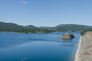
Pactola Lake is the largest reservoir in the Black Hills of South Dakota, United States; it was created by the construction of the Pactola Dam. It was started on 25 November 1952. Contrary to popular belief there is no town at the bottom of Pactola Lake. The Bureau of Reclamation clear cut and cleaned the lake bottom before it filled. The few buildings still there by the time the dam was finished on August 15, 1956 were moved or auctioned off. The only structure under the water is the old Civilian Conservation Corp camp dynamite bunker.
Silver City is an unincorporated community in Pennington County, South Dakota, United States, outside Rapid City. It lies at the head of Pactola Lake on Rapid Creek, and is about 5 miles west of U.S. Route 385 via a paved county road. It is not tracked by the U.S. Census Bureau.
Hanna is a small unincorporated community in Lawrence County, South Dakota, United States. It is located along the Hanna Road in the Black Hills of South Dakota. The small settlement or village is south of the Hanna Campground and west-southwest of the Lead Country Club. The community is located about twelve miles southwest of Lead, South Dakota.
Blacktail is a ghost town in Lawrence County, South Dakota, United States. The name was collected by the United States Geological Survey between 1976 and 1980, and entered into the Geographic Names Information System on February 13, 1980.
Brownsville, also known as Avalon, Esther's Place, and Anderson's Place, is an unincorporated community in Lawrence County, South Dakota. The town was originally a lumber camp, and it was named for contractor David Brown. It is the nearest community to John Hill Ranch-Keltomaki, which is listed on the U.S. National Register of Historic Places.
Ragged Top is a ghost town in Lawrence County, South Dakota, United States. While the town was once a prosperous mining town, it declined due to miners' inability to transport their ore to smelters.
Addie Camp, also known as Kennedyville, Addie Spur, or Canadaville, is a ghost town located in Pennington County, South Dakota, United States. It was a mining camp in the Black Hills.
Bismuth is a ghost town in the Black Hills of Custer County, South Dakota, United States.
Tinton is a ghost town in the Black Hills of Lawrence County, South Dakota, United States. It started out as a gold mining camp and later began to produce tin.
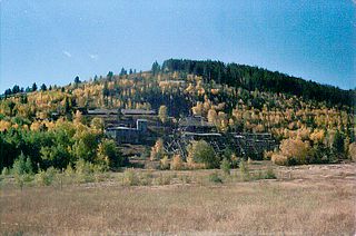
Tigerville or Tiger City (1878–1885) is a ghost town in the Black Hills of Pennington County, South Dakota, United States. The old mining town represents the boom and bust fate of many Western towns.
Trojan, also known as Portland (?-1959), is a ghost town in the Black Hills of Lawrence County, South Dakota, United States. It was created by the Trojan Mining Company.
Etta, also known as Etta Camp and Etta Mine, is a ghost town in Pennington County, South Dakota, United States. It was a successful mining town, known for its discovery of the largest spodumene crystal ever found.
Flatiron, formerly known as Yellow Creek or Flat Iron City, is a ghost town in Lawrence County, South Dakota, United States. It was known for its highly successful gold mining.
Greenwood, also known as Laflin,, is a ghost town in Lawrence County, South Dakota, United States. According to the book “Deadwood Saints and Sinners” by Jerry L. Bryant and Barbara Fifer, Robert Flormann died of pneumonia in Nome, Alaska, on July 4, 1900 and is buried in Seattle, page 168.
Pactola, also known as Camp Crook, (1875–1950s) is a ghost town in Pennington County, South Dakota, United States. It was an early placer mining town and existed into the early 1950s, when it was submerged under Pactola Lake.
Maitland, originally called Garden City and sometimes misspelled Midland, is a ghost town in Lawrence County, South Dakota, United States. It was a mining community that boomed during the Black Hills Gold Rush, but was abandoned by about 1915.
Myers City, today called Myersville, is a ghost town in Pennington County, South Dakota, United States.
Sheridan, originally called Golden City, was an early mining camp in Pennington County, South Dakota, United States. It was the first county seat of Pennington County from 1877 to 1878. It is now submerged under Sheridan Lake.
Novak, also known as Cindell Spur, is a ghost town in Lawrence County, South Dakota, United States. It was an early mining camp.