MetroRapid is an express bus system in Tampa, Florida. Operated by Hillsborough Area Regional Transit, it incorporates some bus rapid transit features. Currently, there is only one line in operation, the North-South line, with an East-West line in the planning phase. Subsequent lines could open depending on the success of the two initial lines.
HART began preliminary planning for a bus rapid transit (BRT) system in 2004, with studies launched in 2005. What is now known as the MetroRapid North-South Line was selected in 2005 to become the first leg of the system, after initial plans to have BRT run along interstate corridors deteriorated. The Nebraska Ave corridor is HART's busiest bus corridor [permanent dead link]. A second route connecting East Tampa to Tampa International Airport via Hillsborough Ave and MLK Blvd was also brought up. In August 2006, the Hillsborough County Board of Commissioners voted to invest $40 million into the BRT project. Further funding has been obtained since then for the North-South route. However, the East-West route remains largely unfunded. [permanent dead link]
Funding
Hillsborough County Community Investment Tax funded the design and construction phases of the MetroRapid North-South project. A June 2012 review of the original project estimate of $31 million determined that the project was under budget by $5.7 million. This funding has been reallocated back to Hillsborough County for its infrastructure needs, if desired. CIT funding is only earmarked for capital improvement costs, and cannot be reallocated for operational costs, such as bus routes.
North-South Line
MetroRapid bus
The MetroRapid North-South Line consists of an approximately 12.5 mile route along Fletcher Avenue and Nebraska Avenue, from Downtown Tampa to USF Area, with 52 stations along the line. It uses 12 low-floor buses, and transit signal priority in order to shorten red lights and lengthen green lights to make transit faster along the line. At major stations, there are ticket vending machines, in order to speed up the boarding process.
Construction of the North-South line began on August 6, 2012 and was largely completed by March, 2013. A two-week soft opening phase took place between May 28, 2013 and June 7, 2013, by which customers could use MetroRapid for free. The line officially began revenue service on June 10, 2013.
Since October 8, 2017, HART established more stops to the Downtown-USF Line, replacing Route 2. The segment to USF to Hidden River Complix is run Weekdays for Route 33.
Weekday, 15-minute service from Marion Transit Center (MTC) to University Area Transit Center (UATC)
Saturday/Sunday, 30-minute service from Marion Transit Center (MTC) to University Area Transit Center (UATC)
Future
HART is planning a second line, called the East-West Line. This line is largely unfunded, and HART is seeking federal funding to assist with this portion of the project. Subsequent lines are planned for the Dale Mabry Highway corridor from Lutz to MacDill Air Force Base, New Tampa via Bruce B. Downs Blvd, and the Selmon Expressway corridor between Downtown Tampa and Brandon. These subsequent lines will be dependent on the success of the two initial lines.
Route name
Starting point
Major transfer points
Terminus
Operation and frequency
Direction
Projected start of service
Notes
North-South Line
Marion Transit Center - Downtown Tampa
Nebraska Ave/Dr. MLK Jr. Blvd Connecting Rt. 32, Nebraska/Busch Blvd Connecting Rt. 39, Union Station Tampa - Amtrak, County Center, University Community Resource Center via Nebraska/Fletcher Ave.
University Area Transit Center - USF Area
Every 15 Minutes between MTC & UATC Weekdays & 30 Minutes Weekends
Bi-Direction - North/South
Opened May 28, 2013. Revenue service began June 10, 2013.
Service updated since October 7, 2018. Currently the only MetroRapid route in service.
East-West Line
Tampa International Airport
NetPark Transfer Center - East Tampa
Temple Terrace City Hall - Temple Terrace
Unknown
Peak Direction - East/West
Unknown
Was planned of being a second MetroRapid Route for HART's bus rapid transit program. So far, it is largely unfunded at this time.
Brandon Line
Dover Rd. Park-n-Ride - Brandon
via Selmon Expressway
Marion Transit Center - Downtown Tampa
Unknown
Peak Direction - East/West
Unknown
Previously used for Route 22X before October 8, 2017
New Tampa Line
New Tampa
via Bruce B Downs Blvd
University Area Transit Center - USF Area
Unknown
Peak Direction - North/South
Unknown
UATC to Wiregrass portion is currently used for Route 275LX
Dale Mabry Hwy Corridor
Lutz Target - Lutz
via Dale Mabry Highway
MacDill AFB - South Tampa
Unknown
Peak Direction - North/South
Unknown
Majority of Dale Mabry Highway is currently used for Route 36. HART's Route 20X currently serves Lutz Target, Pasco in peak direction to and from Downtown Tampa and MacDill Air Force Base.
Kennedy Boulevard/TIA Line
Marion Transit Center - Downtown Tampa
via Kennedy Boulevard
Tampa International Airport
Unknown
Peak direction - East/West
Unknown
Currently used for Route 30
Busch Boulevard/Gunn Highway Line
NetPark Transfer Center - East Tampa
via Busch Blvd/Gunn Hwy
Northwest Transfer Center - Town N' Country
Unknown
Peak direction - East/West
Unknown
Currently used for Route 39
Some information regarding proposed MetroRapid routes came from this link[permanent dead link]
East-West Line
MetroRapid East-West will connect Tampa International Airport, the Westshore Business District and the HART Netpark bus transfer center at Hillsborough Avenue and 56th Street, with connections to the North-South line at Martin Luther King Jr. Boulevard.
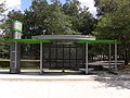
MetroRapid North-South Station C featuring modern design, Ticket Vending Machine, bike rack and solar lighting.
The bus that is planned to be used for MetroRapid.
Miami-Dade Transit (MDT) is the primary public transit authority of Miami, Florida and the greater Miami-Dade County area. It is the largest transit system in Florida and the 15th-largest transit system in the United States. As of 2023, the system has 80,168,700 rides per year, or about 277,400 per weekday in the fourth quarter of 2023. MDT operates the Metrobus with their paratransit STS systems run by LSF. MDT also operates two rail transit systems: Metrorail and Metromover.
Metro Transit is the primary public transportation operator in the Minneapolis–Saint Paul area of the U.S. state of Minnesota and the largest operator in the state. Metro Transit has previously been ranked as one of the best public transit systems in the United States. In 2023, the system had a ridership of 44,977,200, or about 145,600 per weekday as of the fourth quarter of 2023.
The Greater Cleveland Regional Transit Authority is the public transit agency for Cleveland, Ohio, United States and the surrounding suburbs of Cuyahoga County. RTA is the largest transit agency in Ohio, with a ridership of 22,431,500, or about 75,300 per weekday as of the fourth quarter of 2023.
Hillsborough Area Regional Transit provides public transportation for Hillsborough County, Florida. The agency operates fixed-route local and express bus service, paratransit service, demand-response service, MetroRapid service, and the TECO Line Streetcar system. In 2023, the system had a ridership of 12,929,700.
The Milwaukee County Transit System (MCTS) is the largest transit agency in Wisconsin, and is the primary transit provider for Milwaukee County. It ranks among the top 50 transit agencies in the United States for total passenger trips. Milwaukee Transport Services, Inc. is a quasi-governmental agency responsible for the management and operation of the Milwaukee County Transit System. Its bus fleet consists of 360 buses. In 2023, the system had a ridership of 17,507,900, or about 57,600 per weekday as of the fourth quarter of 2023.
The Pinellas Suncoast Transit Authority (PSTA) is a government agency that provides public transportation for Pinellas County, Florida. The authority manages a fixed-route bus system that encompasses over 40 bus routes - including two express routes to Tampa; the Central Avenue Trolley; the Suncoast Beach Trolley; and the bus rapid transit service, the SunRunner.
The Metro Orange Line is a bus rapid transit line in the Twin Cities, Minnesota operated by Metro Transit. The line operates primarily along Interstate 35W from downtown Minneapolis through Richfield and Bloomington before terminating in Burnsville, Minnesota. The Orange Line provides access to 198,000 jobs with roughly a quarter of them outside downtown Minneapolis. The route serves a mix of stations located in the center of the highway, stations near highway exits, and on-street stations. The line has features typical of bus rapid transit systems with off-board fare payment, articulated buses with extra doors, stations with improved passenger amenities, and transit-only bus lanes on portions of the route.
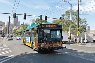
RapidRide is a network of limited-stop bus routes with some bus rapid transit features in King County, Washington, operated by King County Metro. The network consists of seven routes totaling 76 miles (122 km) that carried riders on approximately 64,860 trips on an average weekday in 2016, comprising about 17 percent of King County Metro's total daily ridership.
I-35W & 46th Street station is a Metro Orange Line bus rapid transit station located in Minneapolis, Minnesota. In addition to the BRT service, the station is also served by Metro route 578. The station was constructed as part of the I-35W/Minnesota State Highway 62 Crosstown Commons reconstruction project and opened in 2010. Consisting of two levels, one on East 46th Street, and the other in the median of Interstate 35W, the station was the first of its kind in Minnesota. The station allows for transit routes operating on I-35W to stop for riders without leaving the region's high occupancy toll lane system. The station was designed in anticipation of full bus rapid transit service along I-35W to downtown Minneapolis, a vision that was realized in 2021 with the opening of the Metro Orange Line. The station cost $4.5 million to build.
Metro Busway is a system of bus rapid transit (BRT) routes that operate primarily along exclusive or semi-exclusive roadways known locally as a busway or transitway. There are currently two lines serving 29 stations in the system: the G Line in the San Fernando Valley, and the J Line, serving El Monte, Downtown Los Angeles, Gardena, and San Pedro. The Los Angeles County Metropolitan Transportation Authority (Metro) operates the Metro Busway system.
Bus rapid transit creep is a phenomenon where bus systems that fail to meet the requirements for being considered "true bus rapid transit" are designated as bus rapid transit regardless. These systems are often marketed as a fully realized bus rapid transit system, but end up being described as more of an improvement to regular bus service by proponents of the "BRT creep" term. The Institute for Transportation and Development Policy published several guidelines in an attempt to define what constitutes the term "true BRT", known as the BRT Standard, in an attempt to avert this phenomenon.
The Metro A Line is a bus rapid transit line in the Twin Cities, Minnesota operated by Metro Transit. The A Line operates primarily along the Snelling Avenue corridor and travels through the cities of Minneapolis, Saint Paul, Falcon Heights, and Roseville. From the Blue Line in Minneapolis, the line travels past Minnehaha Park, through the Highland Village commercial area, past Macalester College, and connects to the Green Line near Allianz Field. The line continues through Saint Paul, past Hamline University, before traveling through Falcon Heights and Roseville, where the line passes the Minnesota State Fairgrounds, Har Mar Mall, and terminates at Rosedale Center.
The RapidRide G Line is a future RapidRide bus service in Seattle, Washington, operated by King County Metro on Madison Street between Downtown Seattle and Madison Valley. The line is projected to open for service on September 14, 2024, and cost $133.4 million.
The Metro C Line is a bus rapid transit line in Brooklyn Center and Minneapolis, Minnesota operated by Metro Transit. The line is part of Metro Transit's Metro network of light rail and bus rapid transit lines. The route operates from the Brooklyn Center Transit Center along Penn Avenue and Olson Memorial Highway, terminating in downtown Minneapolis. The route is analogous to the existing Route 19 and is projected to increase ridership on this corridor from 7,000 to 9,000 by 2030. Eventually, part of its route will shift south to Glenwood Avenue from Olson Memorial Highway.
The Metro D Line is a bus rapid transit line in Minneapolis-Saint Paul, Minnesota. The 18.5-mile (29.8 km) route primarily operates on Fremont and Chicago Avenues from Brooklyn Center through Minneapolis to the Mall of America in Bloomington. As part of BRT service, the D Line features "train-like amenities" including improved station facilities, off-board fare payment, modern vehicles, fewer stops, and higher frequency. The current alignment would substantially replace the existing Route 5, the highest ridership bus route in Minnesota.
The Vermont Transit Corridor is a proposed 12.5-mile (20.1 km) bus rapid transit line in the Metro Busway network in Los Angeles, California with plans to convert it to rapid transit in the future. It is planned to operate on a north-to-south route on Vermont Avenue between the B Line's Vermont/Sunset station and the C Line's Vermont/Athens station on the Los Angeles Metro Rail system. The project feasibility study was released in February 2019 with a proposed completion date of 2028 for BRT and after 2067 for rail. It is part of Metro's Twenty-eight by '28 initiative and is partially funded by Measure M. The route will have signal priority at traffic lights and will have a dedicated right of way. Metro reports the initial cost is $425 million.
The Metro B Line is an under construction bus rapid transit route in Minneapolis and St. Paul. The route will operate mostly on Lake Street in Minneapolis before crossing the Mississippi River into St. Paul and operating mostly on Selby Avenue and ending in downtown St. Paul. The route was identified in Metro Transit's 2014 Arterial Transitway Corridors Study as one of eleven local routes to be upgraded to bus rapid transit. The route will have "train-like" features to speed up service, such as signal priority, all-door boarding, further stop spacing, and specialized vehicles. Planning and design was completed in 2021, with construction beginning in May 2023. The line will join a number of Metro Transit's future Metro system lines, as well as the currently operating A Line, C Line, and D Line. Full funding for the line was secured in October 2020 with a final $35 million from the state of Minnesota.
Tempo is a bus rapid transit (BRT) service in Oakland and San Leandro in California. It is operated by AC Transit as Line 1T. The route has dedicated lanes and center-boarding stations along much of the corridor, prepaid fares, signal preemption, and all-door boarding. It is AC Transit's busiest bus route, with an average of 13,615 riders boarding each weekday in Fall 2022.
LinkUS is a transportation initiative in Central Ohio, United States. The project aims to create approximately five rapid transit corridors to support the metro population of Columbus, the capital and largest city in Ohio.
This page is based on this Wikipedia article Text is available under the CC BY-SA 4.0 license; additional terms may apply. Images, videos and audio are available under their respective licenses.