
Murchison is a small riverside rural village located on the Goulburn River in Victoria, Australia. Murchison is located 167 kilometres from Melbourne and is just to the west of the Goulburn Valley Highway between Shepparton and Nagambie. The surrounding countryside contains orchards, vineyards and dairy farms and also HM Prison Dhurringile. At the 2016 census, Murchison had a population of 925.

Aloomba is a town and a locality in the Cairns Region, Queensland, Australia. In the 2016 census, Aloomba had a population of 529 people.
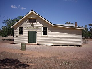
Sandigo is a locality situated on Sandy Creek in the central part of the Riverina. It is situated along the Sturt Highway, about 11 kilometres north west of Kywong and 21 kilometres south east of Narrandera. At the 2016 census, Sandigo had a population of 84 people.

Buxton is a rural locality in the Bundaberg Region, Queensland, Australia. In the 2016 census, Buxton had a population of 430 people.

Hynam is a town and locality in the Australian state of South Australia located in the state's south-east within the Limestone Coast region on the border with the state of Victoria about 302 kilometres south east of the state capital of Adelaide and about 11 kilometres east of the municipal seat of Naracoorte.

East Russell is a locality in the Cairns Region, Queensland, Australia. In the 2016 census, East Russell had a population of 71 people.

Torbanlea is a town and locality in the Fraser Coast Region in Queensland, Australia. In the 2016 census, Torbanlea had a population of 791 people.

Ravensbourne is a locality in the Toowoomba Region local government area of Darling Downs region in southern Queensland, Australia. At the 2016 Australian Census, Ravensbourne and surrounds recorded a population of 248.
Spargo Creek is a locality in central Victoria, Australia. The locality is in the Shire of Moorabool, 96 kilometres (60 mi) north west of the state capital, Melbourne and 34 kilometres (21 mi) north east of the regional city of Ballarat.
Biggara is a locality in north east Victoria, Australia. The locality is in the Shire of Towong local government area and on the Murray River, 470 kilometres (290 mi) north east of the state capital, Melbourne.

Huon is a locality in north east Victoria, Australia. The locality is in the Shire of Indigo local government area and on Lake Hume, 347 kilometres (216 mi) north east of the state capital, Melbourne.

Towong Upper is a locality in north east Victoria, Australia. The locality is in the Shire of Towong local government area and on the Murray River, 461 kilometres (286 mi) north east of the state capital, Melbourne.
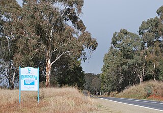
Berringama is a locality in north east Victoria, Australia. The locality is in the Shire of Towong local government area, 418 kilometres (260 mi) north east of the state capital, Melbourne.
Trentham East is a locality in central Victoria, Australia. The locality is in the Shire of Macedon Ranges local government area, 87 kilometres (54 mi) north west of the state capital, Melbourne.
Gooramadda is a locality in north east Victoria, Australia. The locality is in the Shire of Indigo local government area and on the Murray River, 308 kilometres (191 mi) north east of the state capital, Melbourne.
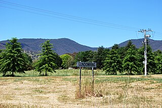
Gundowring is a locality in north east Victoria, Australia. The locality is in the Shire of Indigo local government area, 331 kilometres (206 mi) north east of the state capital, Melbourne.

Kiewa is a locality in north east Victoria, Australia. The locality is in the Shire of Indigo local government area and on the Kiewa River, 343 kilometres (213 mi) north east of the state capital, Melbourne.
Tilley Swamp is a locality in the Australian state of South Australia located in the state's south-east about 199 kilometres (124 mi) south-east of the state capital of Adelaide and about 55 kilometres (34 mi) north of the municipal seat of Kingston SE. The 2016 Australian census, which was conducted in August 2016, reports that the area had a population of 27 people.
North Branch is a locality in the Toowoomba Region, Queensland, Australia. In the 2016 census, North Branch had a population of 39 people.
Damascus is a locality in the Bundaberg Region, Queensland, Australia. In the 2016 census, Damascus had a population of 97 people.


