
Sahand, is a massive, heavily eroded stratovolcano in East Azerbaijan Province, northwestern Iran. At 3,707 m (12,162 ft), it is the highest mountain in the province of East Azarbaijan.

Sabalan is an inactive stratovolcano in the Lesser Caucasus mountain range and Ardabil Province of northwestern Iran.
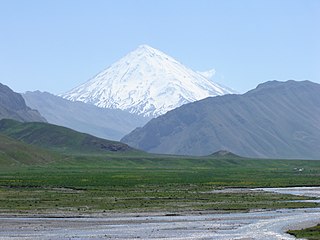
Mount Damavand, a potentially active volcano 5600-m high, is a stratovolcano which is the highest peak in Iran and the highest volcano in Asia. Damāvand has a special place in Persian mythology and folklore. It is in the middle of the Alborz range, adjacent to Varārū, Sesang, Gol-e Zard, and Mīānrūd. It is near the southern coast of the Caspian Sea, in Amol County, Mazandaran Province, 66 km (41 mi) northeast of the city of Tehran.

The Köpet Dag, Kopet Dagh, or Koppeh Dagh, also known as the Turkmen-Khorasan Mountain Range, is a mountain range on the border between Turkmenistan and Iran that extends about 650 kilometres (400 mi) along the border southeast of the Caspian Sea, stretching northwest-southeast from near the Caspian Sea in the northwest to the Harirud River in the southeast. The highest peak of the range in Turkmenistan is the Mount Rizeh, located at the southwest of the capital Ashgabat and stands at 2,940 metres (9,646 ft). The highest Iranian summit is Mount Quchan with 3,191 metres (10,469 ft).

The Karkas mountain chain is a mountain range which is located almost in central Iran. Having a northwest-southeast direction, it is stretched from Kashan to Ardestan for more than 100 kilometres. With an elevation of 3895 metres, the highest peak of the Karkas Mountains is Mount Karkas which is situated close to Natanz.

Bazman is a dormant stratovolcano in a remote desert region of Sistan and Baluchestan Province in south-eastern Iran. A 500-m-wide crater caps the summit of the dominantly andesitic-dacitic volcano, the flanks of which are covered by monogenetic centres especially to the northwest. Bazman is a geologically young volcano which formed mainly in the Quaternary, with the oldest dated rocks being 11.7 million years old and the youngest 0.6 million years. Although no historic eruptions have been reported from Bazman, it does contain fumaroles. Thus Bazman may be regarded as dormant, rather than extinct. Its satellite cones have been the source of basaltic lava flows.

Shir Kuh or Shirkuh is a high peak in the central part of Iran about 40 km (25 mi) south-west of the city of Yazd in Yazd Province. The first woman to climb the mountain was Banoo Khosrawy.

Taftan is an active stratovolcano in south-eastern Iran situated in the Sistan and Baluchestan province. With variable heights reported, all around 4,000 metres (13,000 ft) above sea level, it is the highest mountain in south-eastern Iran. The nearest city is Khash.
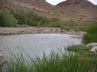
Halīl River is a river stretching for some 390 kilometres (240 mi) running in the Baft, Jiroft and Kahnuj districts of Kerman Province, Iran. It rises at 4,400 metres (14,400 ft) above sea level in the kuh-e shah mountain about 20 kilometres (12 mi) to the north-east of Baft, flowing to the south-west until it is joined by the Zardasht and Rabor rivers. Turning towards the south, if flows along the foothills of the Bahr aseman mountains, then to the south-east until Jiroft Dam, which is 130 metres (430 ft) high, about 40 kilometres (25 mi) upstream of Jiroft 28°51′30″N57°28′0″E) at the confluence with the Narab. It passes some 15 kilometres (9 mi) east of Kahnuj and terminates in the Hamun-e Jaz Murian of Baluchistan.
The Jebal Barez is a mountain chain in the Kerman Province of Iran. This mountain range stretches for some 100 km north-west to south-east, parallel to the Halil Rud, to the north-east of Jiroft and to the south-west of Bam, rising to a maximal elevation of 3,750 m. The mountains of this range are continued by other mountains such as Mount Shahsavaran and Mount Hudian to the south-east. They separate the plain of Hamun-e Jaz Murian from that of Namakzar-e Shahdad and Lut desert.
Hazaran is the name of a massif of the Central Iranian Plateau, Kerman Province, Iran, an eastern outlier of the Zagros Mountains. With an elevation of 4500 metres, it is the highest peak in Kerman Province. The jebal Barez chain is a continuation to the south-east. The Halil River rises in the Bid Khan region. The massif is situated in the area encircled by the cities of Kerman, Bardsir, Sirjan, Baft, Jiroft and Bam.
Qal'eh Hasan Ali is a maar-producing volcanic field located southeast of Kerman Province, Iran. The field is presumed of Quaternary age, though it has produced no historic eruptions. Consisting of 14 maars each of different size, its most significant crater is Great Crater, about 1.2 kilometres (0.75 mi) in width and 200–300 metres (660–980 ft) in depth.
The Alborz range, also spelled as Alburz, Elburz or Elborz, is a mountain range in northern Iran that stretches from the border of Azerbaijan along the western and entire southern coast of the Caspian Sea and finally runs northeast and merges into the Aladagh Mountains in the northern parts of Khorasan. This mountain range is divided into the Western, Central, and Eastern Alborz Mountains. The Western Alborz Range runs south-southeastward almost along the western coast of the Caspian Sea. The Central Alborz runs from west to east along the entire southern coast of the Caspian Sea, while the Eastern Alborz Range runs in a northeasterly direction, toward the northern parts of the Khorasan region, southeast of the Caspian Sea. Mount Damavand, the highest mountain in Iran measuring 5,610.0 m, is located in the Central Alborz Mountains.
Kuhbonan Mountains or Kuhbonan Highlands,, are a group of mountains that are located in the northern part of Kerman Province in Iran. Stretching in a northwest-southeast direction, the mountain range is situated in northwestern, eastern, and southeastern part of the city of Kerman, northeast of the town of Zarand, and southwest of the town of Ravar. With an elevation of 4233 metres, the highest point of the range is Mount Pelvar or Mount Palvar that is located southeast of the city of Kerman and about 25 kilometres east of the town of Mahan.

The main points that are discussed in the geology of Iran include the study of the geological and structural units or zones; stratigraphy; magmatism and igneous rocks; ophiolite series and ultramafic rocks; and orogenic events in Iran.
Mount Marshenan or Mount Mareshnan is a mountain that is located approximately 60 kilometres north-east of the city of Isfahan and 30 kilometres north of Kuhpayeh. With an elevation of 3330 metres, this mountain is about 15 kilometres south-east of Zefreh and 3 kilometres south of the village of Marshenan in Isfahan Province, almost in central Iran. Made chiefly of Eocene andesite and pyroclastic rocks, Mount Marshenan is situated in a central Iranian range, Sahand-Bazman volcanic range or belt, a mountain range which was formed mainly during Eocene volcanism and that stretches approximately from Sahand volcano in the north-west of Iran to Bazman volcano in the south-east of Iran.
Mount Lalehzar is a mountain that is located near the town of Lalehzar about 40 kilometres north-east of the city of Baft in Kerman Province. With an elevation of 4351 metres, this mountain is among of the highest peaks of Iran. Made chiefly of Eocene andesite and pyroclastic rocks, Mount Lalehzar is situated in a central Iranian range, Sahand-Bazman volcanic range or belt, a mountain range which was formed mainly during Eocene volcanism and that stretches approximately from Sahand Volcano in the north-west of Iran to Bazman Volcano in the south-east of Iran.
Qaflankuh or Qaflankuh Mountain Range is a mountain range that is located about 20 kilometres north of the city of Zanjan in Zanjan Province, Iran. With an average width of almost 20 kilometres and a length of about 100 kilometres, this mountain range is stretched in a northwest-southeast direction, beginning from northwest of Zanjan, passing north of Zanjan and ending southeast of Zanjan. The Qezel Owzan River flows in a valley that separates Qaflankuh Mountains on the south from Talish Mountains on the north. With an elevation of 2971 metres, Mount Sendan Dagh is the highest mountain of the range which is located in the southeast section of this mountain range. There are some mineral hot springs containing sulphur in different parts of this range. Geologically, Qaflankuh Mountain Range was formed during the Tertiary volcanism and plutonism and is made mainly of the Eocene volcanic rocks with very small sections of intrusive rocks in the northern and southern parts of the range.
The Sahand-Bazman Volcanic and Plutonic Belt or the Sahand-Bazman Igneous Arc or the Central Iranian Range is a mountain range that is made by igneous and pyroclastic rocks. Located East and almost parallel to the Zagros Mountains, the Central Iranian Range is stretched in a north-west-southeast direction from Mount Sahand in Azerbaijan in the north-west to Mount Bazman in Baluchistan in the Southeastern part of Iran. This range was mainly formed during the Tertiary volcanic and orogenic phase and especially in the Eocene volcanism and plutonism. The Central Iranian Range or the Sahand-Bazman Volcanic Belt includes famous mountains such as the Sahand in East Azerbaijan Province, Mount Karkas in the Karkas Mountains and Mount Marshenan in Isfahan Province, the Jebal Barez, Mount Hezar and Mount Lalehzar in Kerman Province, and the Bazman in the Sistan va Baluchestan Province of Iran.
Shahsavaran is a volcanic field in Iran. It covers an ellipse shaped area west of Bazman volcano. The field has erupted lava cones and lava flows, along with some explosive volcanic activity especially in the eastern part of the field. Volcanic rocks in the field are dominated by andesite, with subordinate basalt, dacite and rhyodacite. The volcanism has lasted from 12 million years ago to recent times, the 2010 Hosseinabad earthquake took place within the field but seems to be unrelated to volcanic activity.