
Canals or artificial waterways are waterways or engineered channels built for drainage management or for conveyancing water transport vehicles. They carry free, calm surface flow under atmospheric pressure, and can be thought of as artificial rivers.

Navigation is a field of study that focuses on the process of monitoring and controlling the movement of a craft or vehicle from one place to another. The field of navigation includes four general categories: land navigation, marine navigation, aeronautic navigation, and space navigation.
A pilot is a person who flies or navigates an aircraft, ship or U.F.O.
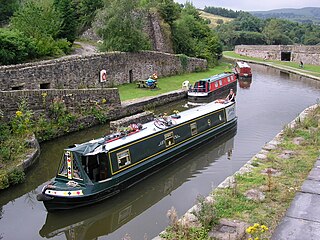
A narrowboat is a particular type of canal boat, built to fit the narrow locks of the United Kingdom. The UK's canal system provided a nationwide transport network during the Industrial Revolution, but with the advent of the railways, commercial canal traffic gradually diminished and the last regular long-distance transportation of goods by canal had virtually disappeared by 1970. However, some commercial traffic continued. From the 1970s onward narrowboats were gradually being converted into permanent residences or as holiday lettings. Currently, about 8580 narrowboats are registered as 'permanent homes' on Britain's waterway system and represent a growing alternative community living on semi-permanent moorings or continuously cruising.

The Aire and Calder Navigation is the canalised section of the Rivers Aire and Calder in West Yorkshire, England. The first improvements to the rivers above Knottingley were completed in 1704 when the Aire was made navigable to Leeds and the Calder to Wakefield, by the construction of 16 locks. Lock sizes were increased several times, as was the depth of water, to enable larger boats to use the system. The Aire below Haddlesey was bypassed by the opening of the Selby Canal in 1778. A canal from Knottingley to the new docks and new town at Goole provided a much shorter route to the River Ouse from 1826. The New Junction Canal was constructed in 1905, to link the system to the River Don Navigation, by then part of the Sheffield and South Yorkshire Navigation.
A waterway is any navigable body of water. Broad distinctions are useful to avoid ambiguity, and disambiguation will be of varying importance depending on the nuance of the equivalent word in other ways. A first distinction is necessary between maritime shipping routes and waterways used by inland water craft. Maritime shipping routes cross oceans and seas, and some lakes, where navigability is assumed, and no engineering is required, except to provide the draft for deep-sea shipping to approach seaports (channels), or to provide a short cut across an isthmus; this is the function of ship canals. Dredged channels in the sea are not usually described as waterways. There is an exception to this initial distinction, essentially for legal purposes, see under international waters.

The canal network of the United Kingdom played a vital role in the Industrial Revolution. The UK was the first country to develop a nationwide canal network which, at its peak, expanded to nearly 4,000 miles in length. The canals allowed raw materials to be transported to a place of manufacture, and finished goods to be transported to consumers, more quickly and cheaply than by a land based route. The canal network was extensive and included feats of civil engineering such as the Anderton Boat Lift, the Manchester Ship Canal, the Worsley Navigable Levels and the Pontcysyllte Aqueduct.

A ship canal is a canal especially intended to accommodate ships used on the oceans, seas, or lakes to which it is connected.
Surf or SURF may refer to:

In physical geography and hydrology, a channel is a landform on which a relatively narrow body of water is situated, such as a river, river delta or strait. While channel typically refers to a natural formation, the cognate term canal denotes a similar artificial structure.

The canals of the United Kingdom are a major part of the network of inland waterways in the United Kingdom. They have a varied history, from use for irrigation and transport, through becoming the focus of the Industrial Revolution, to today's role of recreational boating. Despite a period of abandonment, today the canal system in the United Kingdom is again increasing in use, with abandoned and derelict canals being reopened, and the construction of some new routes. Canals in England and Wales are maintained by navigation authorities. The biggest navigation authorities are the Canal & River Trust and the Environment Agency, but other canals are managed by companies, local authorities or charitable trusts.

A body of water, such as a river, canal or lake, is navigable if it is deep, wide and calm enough for a water vessel to pass safely. Navigability is also referred to in the broader context of a body of water having sufficient under keel clearance for a vessel.

The River Cart is a tributary of the River Clyde, Scotland, which it joins from the west roughly midway between the towns of Erskine and Renfrew and opposite the town of Clydebank.

The draft or draught of a ship is a determined depth of the vessel below the waterline, measured vertically to its hull's lowest—its propellers, or keel, or other reference point. Draft varies according to the loaded condition of the ship. A deeper draft means the ship will have greater vertical depth below the waterline. Draft is used in under keel clearance calculations, where the draft is calculated with the available dept of water to ensure the ship can navigate safely, without grounding. Navigators can determine their draught by calculation or by visual observation.

John Hore was an English engineer, best known for making the River Kennet and River Avon navigable. Hore was one of the earliest English canal engineers, and Sir Alec Skempton wrote that he was "in the first rank among the navigation engineers". The Hutchinson Chronology of World History described his work on the Kennet navigation as "[setting] a new standard for inland waterways, and is an important forerunner of the canals of the Industrial Revolution".
A navigation authority is a company or statutory body which is concerned with the management of a navigable canal or river.

The Mersey and Irwell Navigation was a river navigation in North West England, which provided a navigable route from the Mersey estuary to Salford and Manchester, by improving the course of the River Irwell and the River Mersey. Eight locks were constructed between 1724 and 1734, and the rivers were improved by the construction of new cuts several times subsequently. Use of the navigation declined from the 1870s, and it was ultimately superseded by the Manchester Ship Canal, the construction of which destroyed most of the Irwell section of the navigation and the long cut between Latchford and Runcorn.

The Canadian Navigable Waters Act is one of the oldest regulatory statutes enacted by the Parliament of Canada. It requires approval for any works that may affect navigation on navigable waters in Canada.
Fairway is a part of a water body containing the navigable channel, a route suitable for ships of the larger size.