New Barbadoes Township was a township that was formed in 1710 and existed in its largest extent in pre-American Revolutionary War times in Bergen County, New Jersey. The Township was created from territories that had been part of Essex County that were removed by royal decree and added to Bergen County. After many departures, secessions and deannexations over the centuries, New Barbadoes Township exists today as Hackensack, which adopted its present name in 1921.
Lodi Township was a township that existed in Bergen County, New Jersey, United States, from 1826 to 1935.
Amwell Township was a Township that existed in Hunterdon County, New Jersey, United States, from 1708 to 1846.
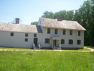
Rockingham is a historic house that was the home of John Berrien (1711–1772) and George Washington's final headquarters of the Revolutionary War. It is located at 84 Laurel Avenue, Franklin Township in Somerset County, New Jersey. The house was originally located on the hillside east of the Millstone River at Rocky Hill. It has been moved within southern Franklin Township several times, and is now closer to Kingston than to Rocky Hill. The residence is a featured part of the Millstone River Valley Scenic Byway. The oldest portion of the house was built as a two-room, two-story saltbox style house c. 1710; a kitchen and additional rooms were added on in the early 1760s, expanding with the Berrien family. The first reference to the house as "Rockingham" does not appear until a 1783 newspaper advertisement to sell the house, a name given most likely in honor of the Marquess of Rockingham.
Ridgefield Township was a township that existed in Bergen County, New Jersey. The township was created in 1871, when Hackensack Township was trisected to form Palisades Township in the northernmost third, Englewood Township in the central strip and Ridgefield Township encompassing the southernmost portion, stretching from the Hudson River on the east to the Hackensack River, with Hudson County to the south. Much of the area had been during the colonial area known as the English Neighborhood. As described in the 1882 book, History of Bergen and Passaic counties, New Jersey,
Ridgefield is the first township in Bergen County which the traveler enters in passing up the Palisades. His first impressions are much like those of old Hendrick Hudson in speaking of a wider extent of country: "A very good land to fall in with, and a pleasant land to see." The valley of the Hackensack invited early settlers in the seventeenth century, and the valley of the Overpeck Creek, a navigable arm of the Hackensack, also attracted settlers quite as early in this direction. Sloops and schooners can pass up this creek nearly to the northern boundary of the township. Ridgefield is bounded on the north by Englewood, on the east by the Hudson, on the south by Hudson County, and on the west by the Hackensack River. The southern boundary is less than two miles in extent, and the northern less than four, and the length of the township from north to south does not exceed four miles. Bellman's Creek, forming part of the southern boundary, the Hackensack, the Overpeck, the Hudson, with more than a dozen other smaller streams and rivulets, bountifully supply the whole township with water. From the western border of the Palisades the land descends to the Overpeck, forming a most beautiful valley, with the land again rising to a high ridge midway between the Overpeck and the Hackensack. From this long ridge, extending far to the north beyond this township, it took its name of Ridgefield.
The New York, Susquehanna and Western, formerly the Midland Railroad, the Jersey City and Albany Railroad, and the Northern Railway of New Jersey—all running northward through the township— afford ample railroad accommodations. The Susquehanna enters the township at Bellman's Creek, and the Northern at about one hundred feet south of the creek, and at a point north and east of the Susquehanna. The Albany road in this locality is not yet constructed, diverging at present from the track of the Susquehanna between Little Ferry and Bogota stations. It has, however, an independent line projected and now under construction to New York City.
Early Settlements. Ridgefield embraces the earliest settlements in the ancient township of Hackensack, antedating even the organization of that township in 1693, and of the county of Bergen in 1675. There seems to have been no town or village compactly built, like the village of Bergen, but there were settlements both of Dutch and English in and about what was subsequently known as English Neighborhood prior to 1675. The Westervelts, the Zimcrmans, the Bantas, and the Blauvelts, all coming from Holland, settled in the middle of the seventeenth century in that locality. The ancestors of Jacob P. Westervelt, now of Hackensack Village, with himself, were born in English Neighborhood. His father was born there in 1776, and was the son of Christopher Westervelt, who was born there certainly as early as 1690, and he was the son of the original ancestor of this family, who came from Holland and settled on Overpeck Creek, within the present limits of Ridgefield township, probably about 1670.

Area code 908 is an area code in Northern New Jersey. The area code covers the North/Central portions of the state. It includes communities in Union County, Somerset County, northern parts of Middlesex County, Hunterdon County, Warren County, and Morris County as well as some cell phones in Monmouth and Ocean Counties.
Hackensack Township was a township that was formed in 1693 within Bergen County, New Jersey, United States. The township was created by the New Jersey Legislature as one of the first group of townships in New Jersey. Bergen County, which had been created in 1682, was thus split into two parts: Hackensack Township to the north, and Bergen Township to the south.
Palisades Township was a township that existed in Bergen County, New Jersey, United States. The township was in existence from 1871 to 1922.
This article is for the now-defunct town in Hudson County, NJ. For the current towns of the same name in Hunterdon County and Union County, seeUnion Township, Hunterdon County, New Jersey and Union Township, Union County, New Jersey.
Orvil Township was a township that existed in Bergen County, New Jersey, United States, from 1886 to 1919.
Nottingham Township was a township that existed for almost 168 years in New Jersey, from 1688 until it was dissolved in 1856.
The Western precinct was one of three components of Somerset County, New Jersey, United States, that was created circa 1745 and existed until 1798.
The Eastern precinct was one of three components of Somerset County, New Jersey, United States, that was created circa 1745 and existed until 1798. It was spelled in records as Estering from 1766-1777, and as Eastern from 1780-1797.
Newton Township is a defunct township that was located in Sussex County, in northwestern New Jersey, in the United States. The township was established as a precinct in 1751, the township is first mentioned in a description of its boundaries in the sessions of the Court of Common Pleas in Morris County. Before the establishment of Sussex County on 8 June 1753, Morris County controlled the sparsely populated areas in the northwestern corner of New Jersey and spanned the territory of three present-day New Jersey counties: Morris, Sussex, and Warren. After ceding territory on several occasions new municipalities were created, Newton Township ceased to exist on 11 April 1864.
Elizabeth Township, also called Elizabethtown, was a township that existed in Essex County, in the U.S. state of New Jersey, from 1664 until 1855.
Elizabeth Borough was a borough that existed in Essex County, in the U.S. state of New Jersey, from 1740 until 1855.
Bergen was a city that existed in Hudson County, New Jersey, United States, from 1855 to 1870.
Harrison Township was created by an act of the New Jersey Legislature on April 13, 1840, and was part of Hudson County which was created from portions of Bergen County, on February 22, 1840.
Rahway Township was a township in New Jersey, United States, that existed from 1804 until it was dissolved in 1861.