
Lake Toba is a large natural lake in North Sumatra, Indonesia, occupying the caldera of a supervolcano. The lake is located in the middle of the northern part of the island of Sumatra, with a surface elevation of about 900 metres (2,953 ft), the lake stretches from 2.88°N 98.52°E to 2.35°N 99.1°E. The lake is about 100 kilometres long, 30 kilometres (19 mi) wide, and up to 505 metres (1,657 ft) deep. It is the largest lake in Indonesia and the largest volcanic lake in the world. Toba Caldera is one of twenty geoparks in Indonesia, and was recognised in July 2020 as one of the UNESCO Global Geoparks.
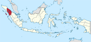
North Sumatra is a province of Indonesia located on the northern part of the island of Sumatra. Its capital and largest city is Medan. It is bordered by Aceh on the northwest and Riau and West Sumatra in the southeast, with two different coastlines located on the Indian Ocean and the Strait of Malacca, and a maritime border with Malaysia to the east. North Sumatra is Indonesia's fourth most populous province after West Java, East Java and Central Java, and the third-largest province on the island of Sumatra after the neighbouring Riau. It covers an area of 72,981 km2.It is approximately same with size of Sierra Leone.According to the 2020 census, the province's population in that year was 14,799,361. The mid-2022 official estimate was 15,115,206. North Sumatra is a multi-ethnic province. The Malay people are regarded as the natives of the east coast of the province, while the west coast of the province is mainly inhabited by the Batak. The central highlands region around Lake Toba is predominantly inhabited by other Batak groups. The Nias people are natives to Nias Island and its surrounding islets. With the opening of tobacco plantations in East Sumatra during the colonial era, the colonial government employed many contract labourers for plantations, mainly Chinese, Javanese and Indian migrants. The majority did not return after their contract ended and decided to stay in the province. The recent rapid urbanisation also attracted neighbouring people from Aceh, Riau and West Sumatra.

Samosir, or Samosir Island, is a large volcanic island in Lake Toba, located in the north of the island of Sumatra in Indonesia. Administratively, Samosir Island is governed as six of the nine districts within Samosir Regency. The lake and island were formed after the eruption of a supervolcano some 75,000 years ago. The island was originally a peninsula connected to the surrounding caldera wall by a small isthmus, which was cut through by the Tano Ponggol Canal in 1907 to aid navigation.

Berastagi, is a town and district of Karo Regency situated on a crossroads on the main route linking the Karo highlands of Northern Sumatra to the coastal city of Medan. Berastagi town is located around 66 km (41 mi) south of Medan and about 1,300 m (4,265 ft) above sea level. The village rose to significance when Dutch settlers in Sumatra opened a boarding school there in the 1920s.

Sibolga is a city and a port located in the natural harbour of Sibolga Bay on the west coast of North Sumatra province, in Indonesia.
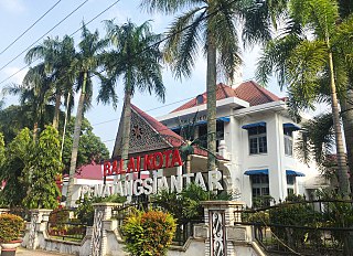
Pematangsiantar, and also known as the City of Pematangsiantar, is an independent city in North Sumatra, Indonesia, surrounded by, but not part of, the Simalungun Regency, making Pematangsiantar an enclave within Simalungun Regency. Pematangsiantar formerly had the status of a second level district and was the administrative centre of the surrounding Regency, but in 1986 it was elevated to Kota (City) and separated from the Regency.
The Uluan Peninsula extends into Lake Toba on the northeastern side toward Medan, in Simalungun Regency and Toba Samosir Regency of North Sumatra province. It has experienced a large amount of uplift because of a series of massive volcanic eruptions that began 1.2 million years ago. The most recent eruption, which occurred 70,000 years ago was among the largest known eruptions ever. Uluan is located on the Porsea caldera, a part of the volcano that erupted approximately 800,000 years ago. Parapat, the primary transit point for tourists going across the lake to Samosir Island, is located on Uluan.
Boho is a Batak village on the island of Samosir on Lake Toba, in the Indonesian province of North Sumatra.

Humbang Hasundutan Regency is a landlocked regency in North Sumatra province of Indonesia. In the east of the regency, Baktiraja District stretches along a short part of the southern shore of Lake Toba in North Sumatra. The regency covers an area of 2,502.71 km2, and it had a population of 171,687 at the 2010 census and 197,751 at the 2020 census; the official estimate as at mid 2022 was 202,299. Its seat is the town of Dolok Sanggul. To the north is Samosir Regency and Pakpak Bharat Regency, to the east is North Tapanuli Regency, and to the west and south is Central Tapanuli Regency, and beyond the latter the Indian Ocean.

Samosir Regency is an inland regency in North Sumatra. It was creatred on 18 December 2003 by splitting away the western districts of the former Toba Samosir Regency. The regency covers a land area of 1,444.25 square kilometres, including the whole of Samosir Island in the inland sea of Lake Toba. It had a population of 119,653 at the 2010 census and 136,441 at the 2020 Census; the official estimate for mid 2022 was 139,337. Its seat is the town of Pangururan.

Simalungun Regency is a regency in North Sumatra, Indonesia. Its seat was formerly at Pematangsiantar, but this city was in 1986 separated from the Regency and made into an independent city (kota), although it remains geographically surrounded by the regency, whose new administrative seat is at Raya. The regency now covers an area of 4,372.5 square kilometres, and at the 2010 census it had a population of 817,720; at the 2020 Census this had risen to 990,246, of whom 497,314 were male and 492,932 were female; the official estimate as at mid 2022 was 1,021,615.
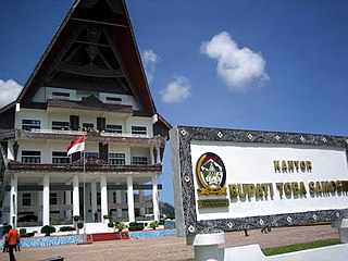
Toba Regency is a landlocked regency in North Sumatra. Its seat is Balige. The regency covers an area of 2,021.8 square kilometres; it had a population of 173,129 at the 2010 census and 206,199 at the 2020 Census; the official estimate as at mid 2022 was 212,133. It includes the eastern shore of the vast inland Lake Toba. The regency was formerly known as Toba Samosir Regency, until its name was officially shortened in 2020.
Balige is a town in North Sumatra province of Indonesia and it is the seat (capital) of Toba Regency. It is 240 kilometers away from Medan. Balige is also a tourist spot to see Lake Toba, the largest crater lake in the world. Balige is 60 kilometers away from Parapat, another important town on Lake Toba.
Lake Sidihoni is a lake located within Samosir Island which itself is an island within Lake Toba, in North Sumatra, Indonesia and is therefore notable for being a "lake on an island in a lake on an island". It is approximately 11–12 km to the east of hot spring pools at Pangururan.

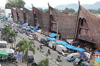
Toba Batak people are the largest ethnic group of the Batak peoples of North Sumatra, Indonesia. The common phrase of ‘Batak’ usually refers to the Batak Toba people. This mistake is caused by the Toba people being the largest sub-group of the Batak ethnic and their differing social habit has been to self-identify as merely Batak instead of ‘Toba’ or ‘Batak Toba’, contrary to the habit of the Karo, Mandailing, Simalungun, Pakpak communities who commonly self-identify with their respective sub-groups.

Sisingamangaraja XII International Airport is an international airport located in Silangit, North Tapanuli, North Sumatra, Indonesia. The airport was known as Silangit International Airport, and was later named after Batak warrior and King Sisingamangaraja XII (1849–1907) in 2018.
Sibisa Airport is an airport located in Ajibata, Toba Samosir, North Sumatra, Indonesia. The airport is located 10 kilometers from Parapat city, Lake Toba.

Girsang Sipangan Bolon is a subdistrict (kecamatan) in Simalungun Regency, North Sumatra, Indonesia. The subdistrict lies on the southwestern side of the regency, and touches the east coast of Lake Toba. The village of Parapat, the main eastern link to Samosir Island, is located within this subdistrict.
MV Sinar Bangun sank on 18 June 2018 in Lake Toba, North Sumatra, Indonesia, during its trip from Simanindo Harbour in Samosir Island to Tiga Ras Harbour in Simalungun Regency. The ferry was carrying 188 passengers and crew. After the sinking, authorities immediately deployed search and rescue personnel to the area. Twenty-one survivors were rescued, three bodies were found and 164 people were listed as missing and presumed dead.


