A prairie lake is a somewhat shallow lake that will empty naturally during dry seasons, allowing a variety of terrestrial plants to flourish upon the rich nutrients in the exposed lakebed, and the lakes eventually refill with water returning to their previous aquatic state.
Northern Florida has four large prairie lakes: Lake Lafayette, Lake Jackson, Lake Iamonia, and Lake Miccosukee. During the antebellum period in Florida, cotton plantation owners used these lakes to graze cattle, sheep, and other animals when dry. Prairie lakes also exist in the upper midwestern United States in Iowa, Montana, and Minnesota in Black Rush Lake, and Lake Shaokatan, a shallow prairie lake in west central Lincoln County. The geology may be different from those in Florida.
Prairies are ecosystems considered part of the temperate grasslands, savannas, and shrublands biome by ecologists, based on similar temperate climates, moderate rainfall, and a composition of grasses, herbs, and shrubs, rather than trees, as the dominant vegetation type. Temperate grassland regions include the Pampas of Argentina, Brazil and Uruguay, and the steppe of Ukraine, Russia and Kazakhstan. Lands typically referred to as "prairie" tend to be in North America. The term encompasses the area referred to as the Interior Lowlands of Canada, the United States, and Mexico, which includes all of the Great Plains as well as the wetter, hillier land to the east.
A marsh is - according to ecological definitions - a wetland that is dominated by herbaceous rather than woody plant species. More in general, the word can be used for any low-lying and seasonally waterlogged terrain. In Europe and in agricultural literature low-lying meadows that require draining and embanked polderlands are also referred to as marshes or marshland.
The blue-winged teal is a species of bird in the duck, goose, and swan family Anatidae. One of the smaller members of the dabbling duck group, it occurs in North America, where it breeds from southern Alaska to Nova Scotia, and south to northern Texas. It winters along the Pacific and Atlantic coasts and south into the Caribbean islands and Central America.
A sea breeze or onshore breeze is any wind that blows from a large body of water toward or onto a landmass; it develops due to differences in air pressure created by the differing heat capacities of water and dry land. As such, sea breezes are more localised than prevailing winds. Because land heats up much faster than water under solar radiation, a sea breeze is a common occurrence along coasts after sunrise. By contrast, a land breeze or offshore breeze is the reverse effect: dry land also cools more quickly than water and, after sunset, a sea breeze dissipates and the wind instead flows from the land towards the sea. Sea breezes and land breezes are both important factors in coastal regions' prevailing winds. The term offshore wind may refer to any wind over open water.
The Gulf Coastal Plain extends around the Gulf of Mexico in the Southern United States and eastern Mexico.
Aspen parkland refers to a very large area of transitional biome between prairie and boreal forest in two sections, namely the Peace River Country of northwestern Alberta crossing the border into British Columbia, and a much larger area stretching from central Alberta, all across central Saskatchewan to south central Manitoba and continuing into small parts of the US states of Minnesota and North Dakota. Aspen parkland consists of groves of aspen, poplar and spruce, interspersed with areas of prairie grasslands, also intersected by large stream and river valleys lined with aspen-spruce forests and dense shrubbery. This is the largest boreal-grassland transition zone in the world and is a zone of constant competition and tension as prairie and woodlands struggle to overtake each other within the parkland.
Paynes Prairie Preserve State Park is a Florida State Park, encompassing a 21,000-acre (85 km2) savanna in Alachua County, Florida lying between Micanopy and Gainesville. It is also a U.S. National Natural Landmark. It is crossed by both I-75 and U.S. 441. It is in the center of the Paynes Prairie Basin. The basin's primary source of drainage is Alachua Sink. During occasional wet periods, the basin will become full. A notable period occurred from 1871 to 1891 when the Alachua Sink was temporarily blocked. During this period, shallow draft steamboats were a frequent sight on Alachua Lake in the center of the prairie. The region was also historically known as the Alachua Savannah. Its drainage has been modified by several canals. Since 1927, Camps Canal has linked the basin to the River Styx which leads to Orange Lake and eventually the Atlantic Ocean through the St. Johns River. That reduced the basins water intake by half. Additional changes to the prairie's environment have been detrimental to its hydrology. In 1970, the state of Florida acquired the land and has been in the process of restoring the environment to a more natural condition ever since.
Taylor Slough, located in the southeastern corner of the Florida Everglades, along with the much larger Shark River Slough farther to the west, are the principal natural drainages for the freshwater Everglades and the essential conduit for providing overland freshwater to Florida Bay.
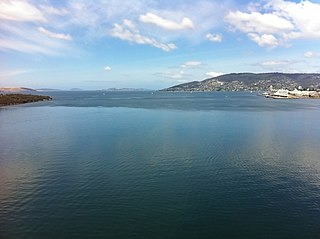
Lake Jackson is a shallow, prairie lake on the north side of Leon County, Florida, United States, near Tallahassee, with two major depressions or sinkholes known as Porter Sink and Lime Sink.
Glacial Lakes State Park is a state park of Minnesota, USA, approximately 5 miles (8.0 km) south of Starbuck. It was founded in 1963 to preserve some of the remaining rolling prairie which previously covered much of the state. Located in the Leaf Mountains, the park and the area around it contains many glacial landforms created by the Wisconsonian glaciation.
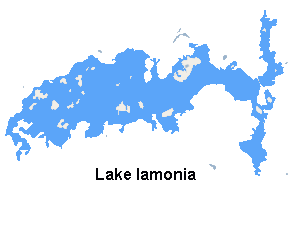
Lake Iamonia⟨aɪ ˈmoʊ njə⟩ is a large, subtropical prairie lake in northern Leon County, Florida, United States, created during the Pleistocene epoch.
Burgesstown Plantation was a large forced-labor farm of 8,100 acres (3,300 ha) in northern Leon County, Florida, United States established by Frederich R. Cotten between 1850 and 1855. Cotten used the forced labor of enslaved people to work his land, which was primarily devoted to growing cotton as a cash crop.
Lake Miccosukee is a large swampy prairie lake in northern Jefferson County, Florida, located east of the settlement of Miccosukee. A small portion of the lake, its northwest corner, is located in Leon County. The small town of Miccosukee, Florida is located on the north eastern shore of the lake in Leon County.
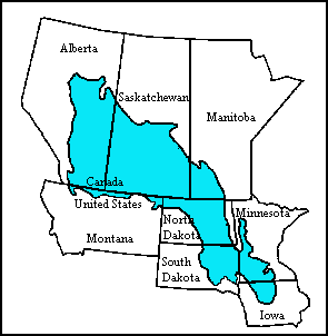
The Prairie Pothole Region is an expansive area of the northern Great Plains that contains thousands of shallow wetlands known as potholes. These potholes are the result of glacier activity in the Wisconsin glaciation, which ended about 10,000 years ago. The decaying ice sheet left behind depressions formed by the uneven deposition of till in ground moraines. These depressions are called potholes, glacial potholes, kettles, or kettle lakes. They fill with water in the spring, creating wetlands, which range in duration from temporary to semi-permanent. The region covers an area of about 800,000 sq. km and expands across three Canadian provinces and five U.S. states. The hydrology of the wetlands is variable, which results in long term productivity and biodiversity. The PPR is a prime spot during breeding and nesting season for millions of migrating waterfowl.
The geology of Minnesota comprises the rock, minerals, and soils of the U.S. state of Minnesota, including their formation, development, distribution, and condition.
Florida sand pine scrub is an endangered subtropical forest ecoregion found throughout Florida in the United States. It is found on coastal and inland sand ridges and is characterized by an evergreen xeromorphic plant community dominated by shrubs and dwarf oaks. Because the low-nutrient sandy soils do not retain moisture, the ecosystem is effectively an arid one. Wildfires infrequently occur in the Florida scrub. Most of the annual rainfall falls in summer. It is endangered by residential, commercial and agricultural development, with the largest remaining block in and around the Ocala National Forest. Lake Wales Ridge National Wildlife Refuge also holds a high proportion of remaining scrub habitat, while the Archbold Biological Station near Lake Placid contains about 20 km2 (7.7 sq mi) of scrub habitat and sponsors biological research on it.
The Long Prairie River is a tributary of the Crow Wing River, 96 miles (154 km) long, in central Minnesota in the United States. Via the Crow Wing River, it is part of the watershed of the Mississippi River, draining an area of 892 square miles (2,310 km2) in a generally rural region.
Before drainage, the Everglades, a region of tropical wetlands in southern Florida, were an interwoven mesh of marshes and prairies covering 4,000 square miles (10,000 km2). The Everglades is both a vast watershed that has historically extended from Lake Okeechobee 100 miles (160 km) south to Florida Bay, and many interconnected ecosystems within a geographic boundary. It is such a unique meeting of water, land, and climate that the use of either singular or plural to refer to the Everglades is appropriate. When Marjory Stoneman Douglas wrote her definitive description of the region in 1947, she used the metaphor "River of Grass" to explain the blending of water and plant life.
The Windom Wetland Management District acquires and manages Waterfowl Production Areas, enforces wetland easements, and provides conservation assistance to landowners in 12 southwestern Minnesota counties. The landscape is dominated by intense, row-crop agriculture, which has led to the drainage of most wetlands and widespread water quality problems. Deteriorating drainage tile systems and the abundance of historic wetland basins provide unlimited opportunities for wetland restorations.
Decodon verticillatus, the sole species in the genus Decodon, is a flowering plant in the family Lythraceae. It is commonly known as waterwillow or swamp loosestrife. It is native to wetlands in the eastern half of the United States and Canada.
This page is based on this Wikipedia article Text is available under the CC BY-SA 4.0 license; additional terms may apply. Images, videos and audio are available under their respective licenses.