Red Rock Job Corps Center

Last updated
Red Rock Job Corps Center entrance sign Red Rock Job Corps Center Sign.jpg
Red Rock Job Corps Center entrance sign

Red Rock Job Corps Center is a Job Corps training center in Colley Township, Sullivan County, Pennsylvania, USA. Like all Job Corps centers, it provides vocational training and education at no cost to participants, who are 16 to 24 years old. The center opened in 1978 and uses the buildings of the former Benton Air Force Station, a Cold War radar facility which operated from 1951 to 1975. Red Rock is on Pennsylvania Route 487 (PA 487) within Ricketts Glen State Park, and is still the site of a Federal Aviation Administration (FAA) radar used for Wilkes-Barre/Scranton International Airport. [1] [2] The Red Rock Job Corps Center has been recognized as one of the top Job Corps centers in the nation.

Job Corps

Job Corps is a program administered by the United States Department of Labor that offers free-of-charge education and vocational training to young men and women ages 16 to 24. Job Corps has a budget of $1.7 billion per year.

Colley Township, Sullivan County, Pennsylvania Township in Pennsylvania, United States

Colley Township is a township in Sullivan County, Pennsylvania, United States. The population was 694 at the 2010 census. The village of Lopez is located in the township.

Sullivan County, Pennsylvania U.S. county in Pennsylvania

Sullivan County is a county located in the U.S. state of Pennsylvania. As of the 2010 census, the population was 6,428, making it the second-least populous county in Pennsylvania. Its county seat is Laporte. The county was created on March 15, 1847, from part of Lycoming County and named for Charles C. Sullivan, leader of the Pennsylvania Senate at that time.

Contents

History

The FAA radar dome in 2010, as seen from Ricketts Glen State Park Ricketts Glen State Park radar.jpg
The FAA radar dome in 2010, as seen from Ricketts Glen State Park

The center is within Ricketts Glen State Park, [1] which opened in 1944 and is mostly on land once owned by lumber baron Robert Bruce Ricketts, for whom the park is named. [3] The park is in two physiographic provinces the Allegheny Plateau and the Ridge-and-Valley Appalachians, with the steep escarpment of the Allegheny Front forming the boundary between them. The Allegheny Front within the park is known as North Mountain and Red Rock Mountain, the latter name coming from a red seam of Huntley Mountain Formation shale and sandstone visible along PA 487. [4]

Ricketts Glen State Park

Ricketts Glen State Park is a Pennsylvania state park on 13,050 acres (5,280 ha) in Columbia, Luzerne, and Sullivan counties in Pennsylvania in the United States. Ricketts Glen is a National Natural Landmark known for its old-growth forest and 24 named waterfalls along Kitchen Creek, which flows down the Allegheny Front escarpment from the Allegheny Plateau to the Ridge-and-Valley Appalachians. The park is near the borough of Benton on Pennsylvania Route 118 and Pennsylvania Route 487, and is in five townships: Sugarloaf in Columbia County, Fairmount and Ross in Luzerne County, and Colley and Davidson in Sullivan County.

A physiographic province is a geographic region with a characteristic geomorphology, and often specific subsurface rock type or structural elements. The continents are subdivided into various physiographic provinces, each having a specific character, relief, and environment which contributes to its uniqueness. The physiographic provinces are then subdivided into smaller physiographic sections.

Allegheny Plateau dissected plateau in the eastern United States

The Allegheny Plateau, in the United States, is a large dissected plateau area in western and central New York, northern and western Pennsylvania, northern and western West Virginia, and eastern Ohio. It is divided into the unglaciated Allegheny Plateau and the glaciated Allegheny Plateau.

In 1950, construction began on the 98-acre (40 ha) Benton Air Force Station, which was completed on September 21, 1951. In addition to the radar, there were barracks for airmen of the 648th Aircraft Control Squadron, based at Fort Indiantown Gap. In 1963 the Federal Aviation Administration began jointly operating the radar facilities. The Benton Air Force Station closed in 1975, though the FAA continued to operate the radar as an auxiliary service for the nearby Wilkes-Barre/Scranton International Airport. [2] [5] The remaining buildings and barracks were converted to the Red Rocks Job Corps Center, which opened in 1978. [2] [5]

Fort Indiantown Gap census designated place in Pennsylvania, USA

Fort Indiantown Gap, also referred to as "The Gap" or "FIG", is a census-designated place and U.S. Army post primarily located in Lebanon County, Pennsylvania. A portion of the installation is located in eastern Dauphin County. It is located adjacent to Interstate 81, 23 miles (37 km) northeast of Harrisburg, just north of the northern terminus of Pennsylvania Route 934 at I-81's Exit 85. The installation is an active National Guard Training Center and serves as headquarters for the Pennsylvania Department of Military and Veterans Affairs and the Pennsylvania National Guard. The fort surrounds Memorial Lake State Park. It is served by the Annville, Pennsylvania post office, ZIP Code 17003. As of the 2010 census the population was 143 residents.

Federal Aviation Administration United States Government agency dedicated to civil aviation matters

The Federal Aviation Administration (FAA) is a governmental body of the United States with powers to regulate all aspects of civil aviation in that nation as well as over its surrounding international waters. Its powers include the construction and operation of airports, air traffic management, the certification of personnel and aircraft, and the protection of U.S. assets during the launch or re-entry of commercial space vehicles. Powers over neighboring international waters were delegated to the FAA by authority of the International Civil Aviation Organization.

Wilkes-Barre/Scranton International Airport airport in Pittston Township, Pennsylvania

Wilkes-Barre/Scranton International Airport is mostly in Pittston Township, Pennsylvania, and spans the border between Luzerne County and Lackawanna County. It is owned and operated by the two counties; it is about 7 miles from Scranton and 8 miles from Wilkes-Barre. It is the fifth largest airport in Pennsylvania by passenger count and calls itself "your gateway to Northeastern Pennsylvania and the Pocono Mountains".

The Job Corps program was established by Congress in the Economic Opportunity Act of 1964, part of President Lyndon Johnson's War on Poverty. [6] In 1996, Red Rock Job Corps Center was given the National Director's Award as the "Top Performer" of 110 Job Corps centers in the US. [7] Since 1998, all Job Corps programs now operate under Title I-C. of the Workforce Investment Act. [8] In 2008, the US Department of Labor awarded a contract for $6.4 million for construction of a new dormitory at the center. [9] Until 2010, the center was run by Management and Training Corporation (MTC). [10] [11] On March 17, 2010, the annual contract for operation of Red Rock was awarded to Adams and Associates, Inc. of Reno, Nevada, for $63,275,192. [12] The current operator is Res-Care, Inc. of Louisville, Kentucky.

Economic Opportunity Act of 1964 civil rights law of the United States

The Economic Opportunity Act of 1964 authorized the formation of local Community Action Agencies as part of the War on Poverty. These agencies are directly regulated by the federal government. "It is the purpose of The Economic Opportunity Act to strengthen, supplement, and coordinate efforts in furtherance of that policy".

War on Poverty 1964 policies of Lyndon B. Johnson

The War on Poverty is the unofficial name for legislation first introduced by United States President Lyndon B. Johnson during his State of the Union address on Wednesday, January 8, 1964. This legislation was proposed by Johnson in response to a national poverty rate of around nineteen percent. The speech led the United States Congress to pass the Economic Opportunity Act, which established the Office of Economic Opportunity (OEO) to administer the local application of federal funds targeted against poverty.

Management & Training Corporation or MTC is a contractor that manages private prisons and United States Job Corps centers, based in Centerville, Utah. MTC's core businesses are corrections, education and training, MTC medical, and economic & social development. MTC operates 24 correctional facilities in eight states. MTC also operates or partners in operating 22 of the 119 Job Corps centers across the country. They also operate in Great Britain, under the name MTCNovo.

Operation

Red Rock Job Corps Center is part of the Job Corps, a program administered by the United States Department of Labor that offers education and vocational training free-of-charge to participants from 16 to 24 years old. [8] According to MTC's website for Red Rock, in 2010 it had 318 students, of which 210 were male and 108 female. [11] The center offers driver's education and classes which allow students to earn their high school diploma or their General Educational Development (GED) certificate. [13] Technical training is available for students to become automobile mechanics, brick masons, carpenters, electricians, plumbers, and workers in the business technology and hotel and hospitality fields. [11] [13]

United States Department of Labor U.S. Department that regulates the workers rights and labor markets

The United States Department of Labor (DOL) is a cabinet-level department of the U.S. federal government responsible for occupational safety, wage and hour standards, unemployment insurance benefits, reemployment services, and some economic statistics; many U.S. states also have such departments. The department is headed by the U.S. Secretary of Labor.

Vocational education studies that prepares a person for a specific occupation

Vocational education is education that prepares people to work as a technician or in various jobs such as a trade or a craft. Vocational education is sometimes referred to as career and technical education. A vocational school is a type of educational institution specifically designed to provide vocational education.

Drivers education formal class or program that prepares a new driver for obtaining a license

Driver's education, driver education, driving education, driver's ed, or driving tuition or driving lessons is a formal class or program that prepares a new driver to obtain a learner's permit or driver's license. The formal class program may also prepare existing license holders for an overseas license conversion or medical assessment driving test or refresher course. It may take place in a classroom, in a vehicle, online, or a combination of the above. Topics of instruction include traffic code or laws and vehicle operation. Typically, instruction will warn of dangerous conditions in driving such as road conditions, driver impairments, and hazardous weather. Instructional videos may also be shown, demonstrating proper driving strategies and the consequences for not observing the rules.

Related Research Articles

Allegheny County, Pennsylvania U.S. county in Pennsylvania

Allegheny County is a county in the southwest of the U.S. state of Pennsylvania. As of 2017 the population was 1,223,048, making it the state's second-most populous county, following Philadelphia County. The county seat is Pittsburgh. Allegheny County is included in the Pittsburgh, PA Metropolitan Statistical Area, and in the Pittsburgh Designated Market Area.

Luzerne County, Pennsylvania County in Pennsylvania

Luzerne County is a county in the Commonwealth of Pennsylvania. According to the U.S. Census Bureau, the county has a total area of 906 square miles (2,350 km2), of which 890 square miles (2,300 km2) is land and 16 square miles (41 km2) is water. It is Northeastern Pennsylvania's second-largest county by total area. As of the 2010 census, the population was 320,918, making it the most populous county in the northeastern part of the state. The county seat and largest city is Wilkes-Barre. Other populous communities include Hazleton, Kingston, Nanticoke, and Pittston. Luzerne County is included in the Scranton–Wilkes-Barre–Hazleton Metropolitan Statistical Area, which has a total population of 555,426.

Lackawanna County, Pennsylvania County in Pennsylvania, United States

Lackawanna County is a county in the U.S. state of Pennsylvania. As of the 2010 census, the population was 214,437. Its county seat and largest city is Scranton.

Benton, Columbia County, Pennsylvania Borough in Pennsylvania, United States

Benton is a borough in Columbia County, Pennsylvania, United States. The population was 824 at the 2010 census. It is part of the Bloomsburg–Berwick Micropolitan Statistical Area.

Scranton, Pennsylvania City in Pennsylvania, United States

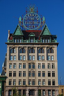
Scranton is the sixth-largest city in the Commonwealth of Pennsylvania. It is the county seat and largest city of Lackawanna County in Northeastern Pennsylvania's Wyoming Valley and hosts a federal court building for the United States District Court for the Middle District of Pennsylvania. With a population of 77,291, it is the largest city in the Scranton–Wilkes-Barre–Hazleton, PA Metropolitan Statistical Area, which has a population of about 570,000. The city is conventionally divided into 8 districts: North Scranton, Southside, Westside, the Hill Section, Central City, Minooka, East Mountain, and Green Ridge, though these areas do not have legal status.

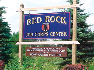
Pennsylvania CareerLink is a collaborative project between multiple agencies to provide career services to Pennsylvania employers, potential employees, and others.

Pennsylvania Route 115 highway in Pennsylvania

Pennsylvania Route 115 (PA 115) is a 35.7-mile-long (57.5 km) north–south state highway in eastern Pennsylvania. It stretches from U.S. Route 209 (US 209) in Brodheadsville, Monroe County to Interstate 81 (I-81) and PA 309 near Wilkes-Barre in Luzerne County. PA 115 passes through rural areas along its route, intersecting PA 903 in Tunkhannock Township, I-80 and PA 940 in Tobyhanna Township, and I-476 in Bear Creek Township. The road serves as a connector between The Poconos and the Wyoming Valley.

Allegheny Islands State Park

Allegheny Islands State Park is a 43-acre (17 ha) Pennsylvania state park in Harmar Township, Allegheny County, Pennsylvania in the United States. The undeveloped park is composed of three alluvial islands located in the middle of the Allegheny River northeast of Pittsburgh. The islands are just north of the boroughs of Oakmont and Plum, and southwest of Cheswick. Bridges for the Pennsylvania Turnpike and the Bessemer and Lake Erie Railroad Branch of the Canadian National Railway cross the Allegheny River at the middle island.

Black Moshannon State Park

Black Moshannon State Park is a 3,481-acre (1,409 ha) Pennsylvania state park in Rush Township, Centre County, Pennsylvania, United States. It surrounds Black Moshannon Lake, formed by a dam on Black Moshannon Creek, which has given its name to the lake and park. The park is just west of the Allegheny Front, 9 miles (14 km) east of Philipsburg on Pennsylvania Route 504, and is largely surrounded by Moshannon State Forest. A bog in the park provides a habitat for diverse wildlife not common in other areas of the state, such as carnivorous plants, orchids, and species normally found farther north. As home to the "[l]argest reconstituted bog/wetland complex in Pennsylvania".

Pennsylvania Route 487 state highway in Pennsylvania, United States

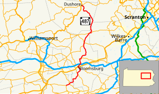
Pennsylvania Route 487 is a 64.2-mile-long (103.3 km), north–south state highway running from PA 61 in Shamokin Township, Northumberland County to PA 87 in Dushore, Sullivan County. In Bloomsburg, PA 487 and US 11 share a brief wrong-way concurrency. After its brief concurrency with PA 118, PA 487 goes up a steep grade through Ricketts Glen State Park. Pennsylvania Route 487 is used to carry traffic up the Fishing Creek valley.

Pennsylvania Route 118 state highway in Lycoming, Columbia, and Luzerne counties in Pennsylvania, United States

Pennsylvania Route 118 (PA 118) is a 42.248-mile-long (67.992 km) state route located in northeastern Pennsylvania. The western terminus of the route is at PA 405 in Hughesville. The eastern terminus is at PA 415 in Dallas. The road is known briefly as East Water Street from its western terminus to its intersection with 6th Street in Hughesville, where it becomes Lairdsville Road for 12 miles (19 km) until crossing PA 42 near Unityville. It joins PA 487 for one mile (1.6 km) in Red Rock, where it passes through the southern part of Ricketts Glen State Park. In 1928, the road between Hughesville and Unityville was designated as part of PA 642 while the portion between Red Rock and Lehman was designated as a portion of PA 115. PA 642 was extended from PA 42 in Unityville to PA 539 in the 1940s. During the 1950s, PA 115 was rerouted from Red Rock to head west and replace PA 642 to Hughesville. PA 115 was also realigned to run between Lehman and Dallas. In 1961, PA 118 replaced the portion of PA 115 between Hughesville and Dallas.

Pennsylvania Route 239 highway in Pennsylvania

Pennsylvania Route 239 (PA 239) is a 36.84-mile-long (59.29 km) state highway located in Luzerne, Columbia and Lycoming Counties in Pennsylvania. The southern terminus is at PA 93 in Nescopeck Township. The northern terminus is at PA 42 in North Mountain. The route heads north from PA 93 and parallels the Susquehanna River between Wapwallopen and Mocanaqua before crossing the river into Shickshinny and forming a concurrency with U.S. Route 11 (US 11). Past Shickshinny, PA 239 runs west through rural areas to Benton, where it has a concurrency with PA 487. The route continues northwest and crosses PA 118 before it reaches its northern terminus.

Red Rock Mountain mountain in Pennsylvania, United States of America

Red Rock Mountain is a mountain located in Luzerne County, Pennsylvania. This summit is actually on the North Mountain escarpment. The escarpment in which Red Rock Mountain is located is a part of the Allegheny Plateau. This summit features a firetower, known as "Grandview" all located within the Ricketts Glen State Park.

Waterfalls in Ricketts Glen State Park waterfalls in Ricketts Glen State Park in the U.S. state of Pennsylvania

There are 24 named waterfalls in Ricketts Glen State Park in the U.S. state of Pennsylvania along Kitchen Creek as it flows in three steep, narrow valleys, or glens. They range in height from 9 feet (2.7 m) to the 94-foot (29 m) Ganoga Falls. Ricketts Glen State Park is named for R. Bruce Ricketts, a colonel in the American Civil War who owned over 80,000 acres (32,000 ha) in the area in the late 19th and early 20th centuries, but spared the old-growth forests in the glens from clearcutting. The park, which opened in 1944, is administered by the Bureau of State Parks of the Pennsylvania Department of Conservation and Natural Resources (DCNR). Nearly all of the waterfalls are visible from the Falls Trail, which Ricketts had built from 1889 to 1893 and which the state park rebuilt in the 1940s and late 1990s. The Falls Trail has been called "the most magnificent hike in the state" and one of "the top hikes in the East".

Ganoga Lake Natural lake Pennsylvania

Ganoga Lake is a natural lake in Colley Township in southeastern Sullivan County in Pennsylvania, United States. Known as Robinson's Lake and Long Pond for most of the 19th century, the lake was purchased by the Ricketts family in the early 1850s and became part of R. Bruce Ricketts' extensive holdings in the area after the American Civil War. The lake is one of the highest in Pennsylvania, which led Ricketts to name it Highland Lake by 1874 and rename it Ganoga Lake in 1881; Pennsylvania senator Charles R. Buckalew suggested the name Ganoga from the Seneca language word for "water on the mountain".

Clemuel Ricketts Mansion A sandstone Georgian-style house on the shore of Ganoga Lake, Sullivan County, Pennsylvania

The Clemuel Ricketts Mansion is a Georgian-style house made of sandstone, built in 1852 or 1855 on the shore of Ganoga Lake in Colley Township, Sullivan County, Pennsylvania in the United States. It was home to several generations of the Ricketts family, including R. Bruce Ricketts and William Reynolds Ricketts. Originally built as a hunting lodge, it was also a tavern and post office, and served as part of a hotel for much of the 19th century.

Ground Equipment Facility QRC

Ground Equipment Facility QRC is an FAA radar station that was part of a Cold War SAGE radar station for aircraft control and warning "from Massachusetts to southern Virginia, and as far out to sea as possible." Benton AFS was also the first operational "regional data processing center" for the GE 477L Nuclear Detection and Reporting System.

Lake Jean lake of the United States of America

Lake Jean is a lake in Luzerne County and Sullivan County, in Pennsylvania, in the United States. It has a surface area of approximately 245 acres (99 ha) and is situated in Colley Township, Sullivan County and Fairmount Township, Luzerne County. The lake's main inflow is the outlet of Ganoga Lake. Lake Jean is fairly shallow, with an average depth of 5.9 feet (1.8 m). It is in the watershed of Fishing Creek. The main rock formations in the lake's watershed include Burgoon Sandstone and the Mauch Chunk Formation. The lake is dammed by the Lake Jean Dam and is owned by the Pennsylvania Department of Conservation and Natural Resources.

References

  1. 1 2 "Ricketts Glen State Park Official map" (pdf). Pennsylvania Department of Conservation and Natural Resources. Retrieved August 20, 2010.
  2. 1 2 3 Bartizek, Ron (November 13, 2005). "A Cold War outpost: Radar installation was part of North American defense system scanning for sneak attacks". Times Leader . p. 1B. Retrieved May 20, 2010.
  3. "Ricketts Glen State Park". Pennsylvania Department of Conservation and Natural Resources . Retrieved August 18, 2010.
  4. Braun, Duane D.; Inners, Jon D. "Pennsylvania Trail of Geology, Ricketts Glen State Park, Luzerne, Sullivan and Columbia Counties, The Rocks, the Glens and the Falls (Park Guide 13)" (PDF). Pennsylvania Department of Conservation and Natural Resources. Retrieved August 18, 2010.
  5. 1 2 "Air Defense Radar Stations: Information for Benton AFS, PA". Radomes.org. Retrieved August 18, 2010.
  6. Garson, G. David. "Economic Opportunity Act of 1964". Prentice-Hall . Retrieved August 18, 2010.
  7. "Red Rock Job Corps Center Honored As Top Performer in Country". U.S. Newswire / HighBeam Research. April 4, 1996. Retrieved August 20, 2010.[ dead link ]
  8. 1 2 "What Is Job Corps?". Job Corps. September 25, 2009. Archived from the original on August 21, 2010. Retrieved August 18, 2010.
  9. Mbuya, Judith (August 18, 2008). "Financial". The Washington Post. p. D3.
  10. "About Us". Red Rock Job Corps Training Center. July 23, 2010. Archived from the original on May 27, 2010. Retrieved August 18, 2010.
  11. 1 2 3 "Red Rock Job Corps Center". Management and Training Corporation. Archived from the original on April 27, 2009. Retrieved August 20, 2010.
  12. "Award notice for the Operation of the Red Rock Job Corps Center". FedBizOpps.gov, US Department of Labor. March 17, 2010. Retrieved August 18, 2010.
  13. 1 2 "Red Rock Job Corps Center". Adams and Associates, Inc. 2010. Retrieved August 18, 2010.

Coordinates: 41°21′30″N76°17′42″W / 41.3583333°N 76.2950000°W / 41.3583333; -76.2950000