
Adullam is an ancient ruin, formerly known by the Arabic appellation ʿAīd el Mâ, built upon a hilltop overlooking the Elah Valley, south of Bet Shemesh in Israel. In the late 19th century, the town was still in ruins. The hilltop ruin is also known by the name Khurbet esh-Sheikh Madkour, named after Madkour, one of the sons of the Sultan Beder, for whom is built a shrine (wely) and formerly called by its inhabitants Wely Madkour. The hilltop is mostly flat, with cisterns carved into the rock. The remains of stone structures which once stood there can still be seen. Sedimentary layers of ruins from the old Canaanite and Israelite eras, mostly potsherds, are noticeable everywhere, although olive groves now grow atop of this hill, enclosed within stone hedges. The villages of Aderet, Neve Michael/Roglit, and Aviezer are located nearby. Access to the site may be obtained by passing through the cooperative small holders' agricultural villages (Moshavim) of Aderet or Neve Michael. The ruin lies about 3 kilometers south of Moshav Neve Michael.

The Texas Hill Country is a geographic region located in the Edwards Plateau at the crossroads of West Texas, Central Texas, and South Texas. Given its location, climate, terrain, and vegetation, the Hill Country can be considered the border between the American Southwest and Southeast.

Burrington Combe is a Carboniferous Limestone gorge near the village of Burrington, on the north side of the Mendip Hills Area of Outstanding Natural Beauty, in North Somerset, England.

Thor's Cave is a natural cavern located at SK09865496 in the Manifold Valley of the White Peak in Staffordshire, England. It is classified as a Karst cave. Located in a steep limestone crag, the cave entrance, a symmetrical arch 7.5 metres wide and 10 metres high, is prominently visible from the valley bottom, around 80 metres (260 feet) below. Reached by an easy stepped path from the Manifold Way, the cave is a popular tourist spot, with views over the Manifold Valley. The second entrance is known as the "West Window", below which is a second cave, Thor's Fissure Cavern.
Etam is a proper name in the Bible. There are five references to the name Etam in the Hebrew Bible:
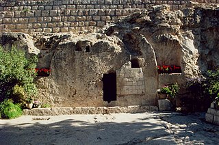
The Garden Tomb is a rock-cut tomb in Jerusalem, which was unearthed in 1867 and is considered by some Christians to be the site of the burial and resurrection of Jesus. The tomb has been dated by Israeli archaeologist Gabriel Barkay to the 8th–7th centuries BC. The re-use of old tombs was not an uncommon practice in ancient times, but this would contradict the biblical text that speaks of a new, not reused, tomb made for himself by Joseph of Arimathea. Also, the trough in front of the tomb and the nearby cistern, described by proponents of the Garden Tomb as part of the tomb's sealing system and as the surrounding garden's source of water, respectively, have both been archaeologically dated to the Crusader period. Currently the organisation maintaining the Garden Tomb refrains from claiming that this is the authentic tomb of Jesus, while pointing out the similarities with the site described in the Bible, and the fact that the Garden Tomb better preserves its ancient outlook than the more traditional, but architecturally altered and time-damaged tomb from the mostly crowded Church of the Holy Sepulchre; for all of these reasons, they suggest that the Garden Tomb is more evocative of the events described in the Gospels.

Hariss is a village is southern Lebanon, in the region of Bint Jbeil.
Bayt ʿIṭāb was a Palestinian Arab village located in the Jerusalem Subdistrict. The village is believed to have been inhabited since biblical times. An ancient tunnel which led to the village spring is associated with story of Samson. Prior to, during, and after its incorporation into Crusader fiefdoms in the 12th century, its population was Arab. Sheikhs from the Lahham family clan, who were associated with the Qays tribo-political faction, ruled the village during Ottoman era. In the 19th century, this clan controlled 24 villages in the vicinity. The homes were built of stone. The local farmers cultivated cereals, fruit trees and olive groves and some engaged in livestock breeding.
Etam is mentioned in Septuagint along with Teqoa, Bethlehem and Phagor. In 2 Chronicles 11:6 it occurs, between Bethlehem and Teqoa, as one of the cities built "for defense in Judah" by Rehoboam. Josephus writes that "there was a certain place, about 50 furlongs distant from Jerusalem which is called Ethan, very pleasant it is in fine gardens and abounding in rivulets of water; whither he (Solomon) used to go out in the morning". Most historical geographers identify the place as being near Solomon's Pools.

Dayr Nakhkhas was a Palestinian Arab village located 20 km northwest of Hebron, overlooking Wadi Bayt Jibrin to the north.

Khirbat Umm Burj was a Palestinian Arab village in the Hebron Subdistrict, sometimes designated in modern maps as Burgin. It occupied an extensive site, stretching about 30 dunams on the crest of a hill, rising some 430 metres (1,410 ft) above sea level, and commanding a good prospect of the surrounding region. It was depopulated during the 1948 Arab–Israeli War on October 28, 1948 during the third stage of Operation Yo'av under the command of Yigal Allon. The site is located 17 km northwest of Hebron.
Yater is a Lebanese municipality located in Bint Jbeil District. It is 112 kilometers away from Beirut.
The Monastery of Saint Maron, also called the Cave of the monks, is an ancient cavern carved out of solid rock in the side of a cliff, located around 200 metres (660 ft) from Ain ez Zarqa, the source of the Orontes river, south of Hermel in Baalbek-Hermel Governorate, northern Lebanon.

The Well of Harod or Spring of Harod is a spring near the two kibbutzim called Ein Harod in the Jezreel Valley in Israel. In Arabic it is called ʿAyn Jalut meaning the Spring of Goliath.
Chihine is a municipality in Southern Lebanon, located in Tyre District, Governorate of South Lebanon.
Ramyah is a village in the Bint Jbeil District in southern Lebanon.
Hanine is a Lebanese municipality located in the Bint Jbeil District.
Selaa, Silảh, is a village in the Tyre District in Southern Lebanon.
Hanaouay, Henawei, is a village in the Tyre District in Southern Lebanon, located north-west of Qana.


