Rue Saint-Louis

Last updated

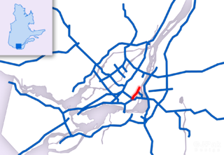
Rue Saint-Louis is a main street in Gatineau, Quebec, Canada, that runs mostly along the north and east side of the Gatineau River in the old city of Gatineau. It starts at the boundaries of the city of Gatineau and the suburban town of Cantley, Quebec and ends at Boulevard Maloney. On its northern end until Autoroute 50, it runs parallel to the Gatineau River, while it briefly runs parallel to the Ottawa River on its eastern end.

Gatineau City in Quebec, Canada

Gatineau, officially Ville de Gatineau, is a city in western Quebec, Canada. It is the fourth-largest city in the province after Montreal, Quebec City, and Laval. It is located on the northern bank of the Ottawa River, immediately across from Ottawa, together with which it forms Canada's National Capital Region. As of 2016, Gatineau had a population of 276,245, and a metropolitan population of 332,057. The Ottawa–Gatineau census metropolitan area had a population of 1,323,783.

Quebec Province of Canada

Quebec is one of the thirteen provinces and territories of Canada. It is bordered to the west by the province of Ontario and the bodies of water James Bay and Hudson Bay; to the north by Hudson Strait and Ungava Bay; to the east by the Gulf of Saint Lawrence and the province of Newfoundland and Labrador; and to the south by the province of New Brunswick and the U.S. states of Maine, New Hampshire, Vermont, and New York. It also shares maritime borders with Nunavut, Prince Edward Island, and Nova Scotia. Quebec is Canada's largest province by area and its second-largest administrative division; only the territory of Nunavut is larger. It is historically and politically considered to be part of Central Canada.

Gatineau River river in western Quebec, Canada, which rises in lakes north of the Baskatong Reservoir and flows south to join the Ottawa River at the city of Gatineau, in Quebec, in Canada

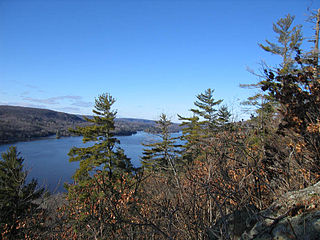
The Gatineau River is a river in western Quebec, Canada, which rises in lakes north of the Baskatong Reservoir and flows south to join the Ottawa River at the city of Gatineau, Quebec. The river is 386 km (239.8 mi) long and drains an area of 23,700 km².

Contents

Prior to the amalgamation of the city of Gatineau, Rue Saint-Louis was a relatively minor street in the Pointe-Gatineau/La Baie neighbourhood that ran from east of Boulevard Greber to Rue Jacques-Cartier where it became former Avenue Du Golf (Golf Avenue) for the remaining stretch on to Boulevard Maloney. Between Autoroute 50 and Boulevard Greber, it was formerly known as Boulevard Archambault, a small residential artery through the western portions of Pointe-Gatineau.

Neighbourhoods of Gatineau

List of neighbourhoods in the City of Gatineau, Quebec, Canada.

Through most of the stretch between Autoroute 50 and Cantley, Rue Saint-Louis is also known as Route 307. That section was formerly known as Avenue Principale before the 2002 amalgamation - this street name is not to be confused with Rue Principale, which is for the former city of Aylmer's main commercial area.

Quebec Autoroute 50 highway in Quebec

Autoroute 50 is an Autoroute in western Quebec, Canada. It links the City of Gatineau and Canada's National Capital Region to the Greater Montreal area.

Quebec Route 307 highway in Quebec

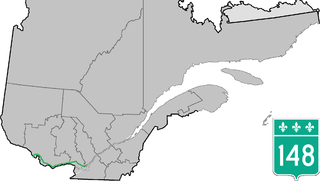
Route 307 is a provincial road located in the Outaouais region of Quebec. The road runs mostly parallel to the Gatineau River on the eastern side of it. It starts at the corner of Rue Saint-Louis and Boulevard Greber in the Gatineau sector of the city of Gatineau. It runs north of Gatineau and ends in Val-des-Bois at the junction of Route 309 which runs from the Buckingham sector north into the Upper Laurentians.

Aylmer, Quebec Sector within City of Gatineau in Quebec, Canada

Aylmer is a former city in Quebec, Canada. Located on the Ottawa River and Route 148, in 2002 it amalgamated into the Quebec city of Gatineau, which is a component part of Canada's National Capital Region. Aylmer's population in 2011 was 55,113. It is named after Lord Aylmer, who was a governor general of British North America and a lieutenant governor of Lower Canada from 1830 to 1835.

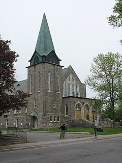
This street is the location of the Collège Saint-Alexandre, a private secondary school, one of two in the city, the other being the Collège Saint-Joseph de Hull institution for girls. A professional education centre is also located a few blocks away It is also home to La Baie Park which is the site of the city's annual Gatineau Hot Air Balloon Festival, and the Bowater plant.

Collège Saint-Alexandre

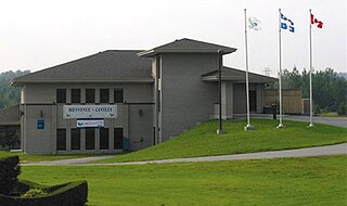
Collège Saint-Alexandre is a private secondary school located in Gatineau, in the Outaouais region, in the province of Quebec, Canada. It is located on Rue Saint-Louis in the Gatineau sector in the Limbour neighbourhood.

Private schools, also known to many as independent schools, non-governmental, privately funded, or non-state schools, are not administered by local, state or national governments. Children who attend private schools may be there because they are dissatisfied with public schools in their area. They may be selected for their academic prowess, or prowess in other fields, or sometimes their religious background. Private schools retain the right to select their students and are funded in whole or in part by charging their students for tuition, rather than relying on mandatory taxation through public (government) funding; at some private schools students may be able to get a scholarship, lowering this tuition fee, dependent on a student's talents or abilities, need for financial aid, or tax credit scholarships that might be available. Some private schools are associated with a particular religion, such as Judaism or Roman Catholicism. For the past century, roughly one in 10 U.S families has chosen to enroll their children in private school.

Secondary school building and organization where secondary education is provided

A secondary school is both an organization that provides secondary education and the building where this takes place. Some secondary schools can provide both lower secondary education and upper secondary education, but these can also be provided in separate schools, as in the American middle school- high school system.

Alonzo Wright Bridge

The busiest section of the road is located near the Alonzo Wright Bridge at the corner of Boulevard La Vérendrye. Traffic coming from Cantley, Touraine, Limbour, Côte d'Azur, Mont-Luc and other areas further east all meet up at that location, causing significant slowdowns during rush hours. It also serves as an alternative route to Autoroute 50 when it is either closed or completely congested in the morning and afternoon. The same situation occurs during the rush hour on Route 105 in Chelsea which connects the bridge.

Cantley, Quebec Municipality in Quebec, Canada

Cantley, Quebec, Canada, is a rural municipality north of the city of Gatineau, east of the Gatineau River, located within Canada's National Capital Region approximately 17 km from Parliament Hill. Its roots are in farmland, but recent housing projects since its creation in 1989 have resulted in a high rate of population growth. The population in the Canada 2011 Census was 9,888. French is the first language of 87% of Cantley's residents.

Quebec Route 105 highway in Quebec

Route 105 is a north-south highway in Quebec, Canada. It runs from Hull, where it is known as Boulevard Saint-Joseph, to Grand-Remous where it ends at Route 117.

Chelsea, Quebec Municipality in Quebec, Canada

Chelsea is a municipality located immediately north of Gatineau, Quebec, Canada and about 10 km north of Ottawa. Chelsea is located within Canada's National Capital Region. It is the seat of Les Collines-de-l'Outaouais Regional County Municipality. Its population was 7,538 in the Canada 2016 Census.

The situation had deteriorated when Boulevard La Vérendrye was extended west to connect with the bridge in 1999 as well extensive housing developments in Limbour, Mont-Luc and Cantley. There are plans to widen the bridge, which was built in 1964, to possibly four lanes but they have not advanced past the preliminary stages. In addition, plans for Autoroute 550 would have seen an additional bridge further upstream. Since its opening, there haven't been any major changes to the bridge's structure despite the rapid traffic growth. A large piece of concrete fell into the Gatineau River leaving a hole in the eastbound lane and concerns about the structure of the bridge. The trailer of an automobile was also caught in the hole. Workers had patch the hole a few hours after the incident. [1]

Neighbourhoods

See also

Related Research Articles

Quebec Autoroute 720 highway in Quebec

Autoroute 720 (A-720), known as the Ville-Marie Expressway (English) or Autoroute Ville-Marie (French) is an Autoroute highway in the Canadian province of Quebec that is a spur route of Autoroute 20 in Montreal. Its western terminus is located at the Turcot Interchange, a junction with Autoroute 15 and Autoroute 20, and its eastern terminus is near the Jacques Cartier Bridge, where the highway merges with Notre-Dame Street. The Autoroute Ville-Marie designation is named after the downtown borough of Ville-Marie, through which the expressway is routed.

Boulevard Gréber is an important principal arterial road in Gatineau, Quebec. It runs from Montee Paiement to the Gatineau River. It is named after French urban planner Jacques Gréber. It was once part of Route 148 of the provincial network.

Boulevard Maloney is one of Gatineau's main commercial roads. It starts at Autoroute 50 via an incomplete interchange and ends at the boundary with the former city of Masson-Angers. It is also known as Route 148. However, one may notice a blue shield sign of the highway on the westbound lane at Boulevard Gréber even if it is not the highway itself as the western portion previous terminated at Maloney before more extensions towards Masson-Angers were made in 1986. Route 148 continues further east towards Buckingham and further east to Laval. Prior to the construction of A-50, was the main roadway through the urban community towards Montreal, the Papineau region and the Laurentides.

Boulevard Saint-Joseph

Boulevard Saint-Joseph is a commercial boulevard in the former city of Hull, Quebec. It runs from Boulevard Alexandre-Tache to the boundaries of the city of Gatineau and the suburban town of Chelsea.

Boulevard Maisonneuve

Boulevard Maisonneuve is an important arterial in the heart of Downtown Gatineau, Quebec. It serves as connector route between the Portage Bridge from Ottawa to Quebec Autoroutes 5 and 50 as well as Boulevard Fournier towards the Gatineau sector of the city, northern portions of the Hull sector and the northern east suburbs. It also gives access to the Macdonald-Cartier Bridge and the Alexandra Bridge.

The Rapibus is a bus rapid transit system for the Société de Transport de l'Outaouais (STO) in the city of Gatineau, Quebec. Construction was completed in the summer of 2013 with service beginning in the fall. The Rapibus aims to speed up the service for commuters in growing sub-divisions in the northern and eastern areas of the city by alleviating the congestion on key arteries currently served by bus-designated lanes. A direct link to Ottawa is included.

Boulevard des Allumettières

Boulevard des Allumettières is a major 13.7 km arterial road in Gatineau, Quebec, Canada, that connects Aylmer and Hull sectors of the city running from Eardley Road to the Alexandra Bridge towards Ottawa. It is the most recent east-west arterial connection from the West to the downtown core and construction of the entire length was completed during the fall of 2007.

Boulevard Fournier is a main route in the city of Gatineau, Quebec that connects the Gatineau and Hull sectors. It starts as the extension of Boulevard Greber in the old city of Gatineau and ends at the entrance of the downtown core where it becomes Boulevard Maisonneuve which connects the Portage Bridge towards Ottawa. It was once part of Route 148 until the Quebec Ministry of Transportation rerouted the provincial highway onto Autoroute 50 and Autoroute 5 as a concurrency.

Rue Laurier is a main street located in the heart of the City of Gatineau, Quebec. It starts at Rue Eddy and ends at Rue Dussault.

Quebec Route 148 highway in Quebec

Route 148 is an east-west highway in Quebec, Canada. It runs from junction of Autoroute 13 and Autoroute 440 in Laval in the Montreal region to the Ontario-Quebec border in L'Isle-aux-Allumettes in western Quebec. For most of its length, Route 148 follows the north shore of the Ottawa River where it acted as the principal route between communities in the Outaouais region until the completion of Autoroute 50 in 2012. At the Ontario-Quebec border in L'Isle-aux-Allumettes Route 148 continues into Ontario as Highway 148.

Quebec Route 117 highway in Quebec

Route 117 is a provincial highway within the Canadian province of Quebec, running between Montreal and the Quebec/Ontario border where it continues as Highway 66 east of Kearns, Ontario. It is an important road as it is the only direct route between southern Quebec and the Abitibi-Témiscamingue region.

Polyvalente de lÉrablière

The Polyvalente de l'Érablière is a french language public high school located in Gatineau, Quebec. It is located in the Côte d'Azur/Limbour district of the Gatineau sector at the intersection of rue de Cannes and Boulevard la Verendrye.

The Canal de l'Aqueduc is an open-air aqueduct canal on the Island of Montreal in Quebec, Canada, serving part of the drinking water needs of the city of Montreal.

Côte-Saint-Paul Neighbourhood in Montreal, Quebec, Canada

Côte-Saint-Paul is a neighbourhood located in the Southwest Borough of Montreal, Quebec, Canada.

References

Route map: Google

KML file (edithelp)
KML is from Wikidata
  1. La Haye, Dominique (June 28, 2007). "Le pont Alonzo-Wright à Gatineau fermé temporairement". Le Droit. p. 4.