Saint Peter Islands

Last updated
Saint Peter Islands
Ostrova sv petra2.PNG
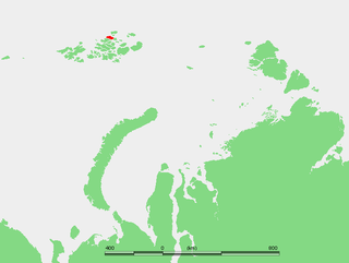
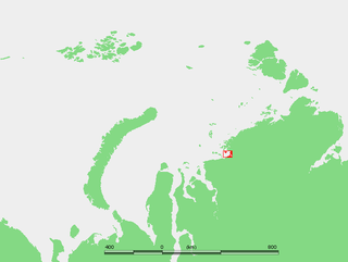
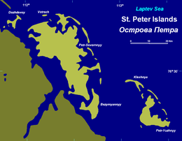
The Saint Peter Islands at the northeastern end of the Taymyr Peninsula
Kara sea2SP.PNG
Geography
Location Laptev Sea
Coordinates 76°35′N113°0′E / 76.583°N 113.000°E / 76.583; 113.000 Coordinates: 76°35′N113°0′E / 76.583°N 113.000°E / 76.583; 113.000
ArchipelagoSaint Peter Islands
Total islands19
Administration
Russia
Krai Krasnoyarsk Krai
Demographics
Populationuninhabited

The Saint Peter Islands, also known as Saint Petra Islands or Petra Islands (Russian : Острова Петра, Ostrova Petra) are two islands covered with tundra vegetation, shingle and ice. These islands, as well as some other islands nearby (Ostrova Andreia, Ostrov Pavla) were originally named after Christian Apostles. The climate is Arctic and severe with frequent blizzards in the winter. The sea surrounding these Islands is covered with fast ice most of the year and is obstructed by pack ice even in the summer, so that these islands are merged with the mainland and animals can go across the ice. [1]

Russian language East Slavic language

Russian is an East Slavic language, which is official in the Russian Federation, Belarus, Kazakhstan and Kyrgyzstan, as well as being widely used throughout Eastern Europe, the Baltic states, the Caucasus and Central Asia. It was the de facto language of the Soviet Union until its dissolution on 25 December 1991. Although, nowadays, over two decades after the breakup of the Soviet Union, Russian is used in official capacity or in public life in all the post-Soviet nation-states, as well as in Israel and Mongolia, the rise of state-specific varieties of this language tends to be strongly denied in Russia, in line with the Russian World ideology.

Tundra biome where the tree growth is hindered by low temperatures and short growing seasons

In physical geography, tundra is a type of biome where the tree growth is hindered by low temperatures and short growing seasons. The term tundra comes through Russian тундра from the Kildin Sami word тӯндар meaning "uplands", "treeless mountain tract". Tundra vegetation is composed of dwarf shrubs, sedges and grasses, mosses, and lichens. Scattered trees grow in some tundra regions. The ecotone between the tundra and the forest is known as the tree line or timberline.

Shingle beach

A shingle beach is a beach which is armoured with pebbles or small- to medium-sized cobbles. Typically, the stone composition may grade from characteristic sizes ranging from 2 to 200 millimetres diameter.

Contents

This island group belongs to the Krasnoyarsk Krai administrative division of Russia. None of these islands have had much historical importance, except for the fact that they are located very close to the Northern Sea Route. [2]

Krasnoyarsk Krai First-level administrative division of Russia

Krasnoyarsk Krai is a federal subject of Russia, with its administrative center in the city of Krasnoyarsk—the third-largest city in Siberia. Comprising half of the Siberian Federal District, Krasnoyarsk Krai is the largest krai in the Russian Federation, the second largest federal subject and the third largest subnational governing body by area in the world, after Sakha and the Australian state of Western Australia. The krai covers an area of 2,339,700 square kilometers (903,400 sq mi), which is nearly one quarter the size of the entire country of Canada, constituting roughly 13% of the Russian Federation's total area and containing a population of 2,828,187, or just under 2% of its population, per the 2010 Census.

Northern Sea Route

The Northern Sea Route is a shipping route officially defined by Russian legislation as lying east of Novaya Zemlya and specifically running along the Russian Arctic coast from the Kara Sea, along Siberia, to the Bering Strait. The entire route lies in Arctic waters and within Russia's exclusive economic zone (EEZ). Parts are free of ice for only two months per year. The overall route on Russia's side of the Arctic between North Cape and the Bering Strait has been called the Northeast Passage, analogous to the Northwest Passage on the Canada side.

Geography

The Saint Peter Islands are surrounded by narrow beach ridges and swales. They are located in the Laptev Sea coastal region, off the eastern shores of the Taymyr Peninsula, between Bukhta Marii Pronchishchevoy and Bukhta Faddeya. [3]

Swale (landform) low tract of land

A swale is a shallow channel with gently sloping sides. A swale may be either natural or man-made. Artificial swales are often infiltration basins, designed to manage water runoff, filter pollutants, and increase rainwater infiltration.

Laptev Sea Marginal sea in the Arctic Ocean north of Siberia between the Kara Sea and the East Siberian Sea

The Laptev Sea is a marginal sea of the Arctic Ocean. It is located between the northern coast of Siberia, the Taimyr Peninsula, Severnaya Zemlya and the New Siberian Islands. Its northern boundary passes from the Arctic Cape to a point with co-ordinates of 79°N and 139°E, and ends at the Anisiy Cape. The Kara Sea lies to the west, the East Siberian Sea to the east.

Taymyr Peninsula peninsula

The Taymyr Peninsula is a peninsula in the Far North of Russia, in the Siberian Federal District, that forms the northernmost part of the mainland of Eurasia. Administratively it is part of the Krasnoyarsk Krai Federal subject of Russia.

Other adjacent coastal islands

See also

Related Research Articles

Kamenny Islands island in Russia

Kamenny Islands are a group of three islands in the Neva delta, in Saint Petersburg, Russia.

Hooker Island island

Hooker Island is one of the central islands of Franz Josef Land. It is located in the central area of the archipelago at 80.23°N 53.02°E. It is administered by the Arkhangelsk Oblast, Russia.

Jackson Island island in Russia

Jackson Island is an island located in Franz Josef Land, Arkhangelsk Oblast, Russian Federation. This island is part of the Zichy Land subgroup of the central part of the archipelago.

Wilczek Land island

Wilczek Land, is a rather large island located at 80.58°N 60.5°E and is part of Franz Josef Land, in Arctic Russia.

Nordenskiöld Archipelago archipelago

The Nordenskiöld Archipelago or Nordenskjold Archipelago is a large and complex cluster of islands in the eastern region of the Kara Sea. Its eastern limit lies 120 km (75 mi) west of the Taymyr Peninsula.

Hall Island (Arctic) island

Hall Island is an island in Franz Josef Land, Arkhangelsk Oblast, Russia.

Salisbury Island (Russia) island located in central area of Franz Josef Land, Russia

Salisbury Island, is an island located in the central area of Franz Josef Land, Russia.

Salm Island island in Russia

Salm Island is a roughly round-shaped island in Franz Josef Land, Arkhangelsk Oblast, Russia.

Karl-Alexander Island island

Karl Alexander Island, also known as Zemlya Karla-Alexandra, is an island in Franz Josef Land, Russia.

Shokalsky Island island

Shokalsky Island is an island in the Kara Sea, in Russia. It is located on the eastern side of the mouth of the Ob River, off the tip of the narrow northwestern arm of the Gydan Peninsula. It is separated from it by a narrow strait full of islets known as Gydanskiy Proliv.

Kirov Islands archipelago

The Kirov Islands or Sergey Kirov Islands is an island group in the Kara Sea, Russian Federation. It is an archipelago of small islands covered with tundra vegetation located about 140 km from the coast of Siberia and 100 km to the northwest of the Nordenskiöld Archipelago.

Zveroboy Islands

The Zveroboy Islands is a group consisting of a large island and a few scattered small islets. The main island is 17 km in length. It is covered with tundra vegetation and has a lake. This island group is located in the Pyasino Gulf, in the Kara Sea, northeast of Dikson, off the coast of Siberia.

Voronina Island island group

Voronina Island or Voronina Islands is an isolated two-island group composed of a larger island and a narrow island on its northern side separated by a 3 km wide sound.

Faddey Islands

The Faddey Islands is a group of islands in the Laptev Sea, Russia.

Oleny Island island in the Kara Sea

Oleny Island is a single island in the Kara Sea just a few kilometers offshore, north of the coast of one of the arms of the Gydan Peninsula in North Siberia. It is covered with tundra and swamps and it is 53 km in length and its average width is 27 km, having an area of 1197 km². Its latitude is 72° 24' N and the longitude 77° 45' E.

Komsomolskaya Pravda Islands Island group in Krasnoyarsk Krai, Russian Federation

The Komsomolskaya Pravda Islands are an archipelago in the far north of the Russian Federation. The islands are uninhabited and are covered with tundra vegetation, shingle and ice.

Heiberg Islands island group

The Heiberg Islands, spelt Geyberg, Gejberg or Geiberg is a group of four small islands covered with tundra vegetation and with scattered stones on their shores. They lie in the Kara Sea, between the bleak coast of Siberia's Taymyr Peninsula and Severnaya Zemlya. These islands are between 35 and 45 km from the continental shore.

Firnley Islands

The Firnley Islands is a group of three small islands covered with tundra vegetation and with scattered stones on their shores. They lie in the Kara Sea, close to the bleak coast of Siberia's Taymyr Peninsula, not far east of the Nordenskjold Archipelago. These islands lie about 35 km from the continental shore.

Dunay Islands

The Dunay Islands, or Duunay Aryta, is a group of islands in the Laptev Sea. They are located close to the mouths of the Lena River, off the northwestern shores of the Lena Delta.

Russian Arctic islands island in Russia

The Russian Arctic islands are a number of islands groups and sole islands scattered around the Arctic Ocean.

References

  1. GoogleEarth - Location
  2. William Barr, The First Soviet Convoy to the Mouth of the Lena.
  3. Geographical names